
FCCInfo.com
A Service of Cavell, Mertz & Associates, Inc.
(855) FCC-INFO
|
|
|
|
|
||||||||||||||||
|
|
W233BG Channel: 233D 94.5 MHz Cincinnati, Ohio Service: FX - A translator or application for a translator. Facility ID: 147557 Fac. Service: FX Programming Delivery Method: Unspecified Status: License Application Accepted: 01/17/2013 Application Granted: 05/21/2013 File Number: BLFT-20130117ACF License Expires: 00/00/0000 Prefix Type: This is a license for a translator Application Type: Amendment FCC Website Links: LMS Facility Details This Application CDBS Application Other W233BG Applications Other W233BG Applications in CDBS Including Superseded Applications Mailing Address Correspondence for W233BG Correspondence related to application BLFT-20130117ACF Service Contour - Open Street Map or USGS Map (60 dBu) Service Contour - KML / Google Earth (60 dBu) Class: D, A Noncommercial educational operating with no more than 10W Site Location: 39-06-59.2 N 84-30-06.8 W (NAD 83) Site Location: 39-06-59.0 N 84-30-07.0 W (Converted to NAD 27) Effective Radiated Power: 0 kW Horiz. ; 0.099 kW Vert. Transmitter Output Power: 0.168 kW Antenna Center HAAT: 235.8 m Horiz.; 0 m Vert. Antenna Center AMSL: 0 m Horiz.; 450 m Vert. Antenna Center HAG: 0 m Horiz.; 213 m Vert. Site Elevation: 237 m. (778 ft.) Height Overall*: 295 m (968 ft.) (* As Filed In This Application, may differ from ASR Data, Below.) Directional Antenna Antenna Make/Model: None Antenna ID: 61047 Polarization:
| ||||||||||||||||||
| Antenna Data for Antenna Id: 61047 W233BG FX File: BLFT-20130117ACF None - Service: FX Pattern and Field Values Include a 291° Clockwise Rotation | 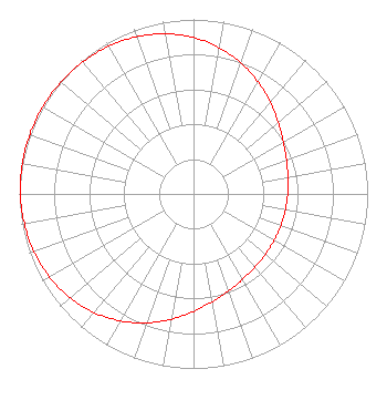 | ||||||||||||||||||
| Azimuth | Ratio | Azimuth | Ratio | Azimuth | Ratio | Azimuth | Ratio | ||||||||||||
| 1 | 0.892 | 11 | 0.845 | 21 | 0.792 | 31 | 0.735 | ||||||||||||
| 41 | 0.679 | 51 | 0.630 | 61 | 0.592 | 71 | 0.566 | ||||||||||||
| 81 | 0.549 | 91 | 0.540 | 101 | 0.535 | 111 | 0.534 | ||||||||||||
| 121 | 0.535 | 131 | 0.540 | 141 | 0.549 | 151 | 0.566 | ||||||||||||
| 161 | 0.592 | 171 | 0.630 | 181 | 0.679 | 191 | 0.735 | ||||||||||||
| 201 | 0.792 | 211 | 0.845 | 221 | 0.892 | 231 | 0.929 | ||||||||||||
| 241 | 0.956 | 251 | 0.975 | 261 | 0.987 | 271 | 0.995 | ||||||||||||
| 281 | 0.999 | 291 | 1.000 | 301 | 0.999 | 311 | 0.995 | ||||||||||||
| 321 | 0.987 | 331 | 0.975 | 341 | 0.956 | 351 | 0.929 | ||||||||||||
Structure Registration Number 1019014 [ASR Heights Differ from W233BG Application] Structure Type: TOWER Registered To: Vertical Bridge CC FM, LLC Structure Address: 1906 Highland Ave Cincinnati, OH County Name: Hamilton County ASR Issued: 11/08/2018 Date Built: 10/01/1987 Site Elevation: 236.5 m (776 ft.) Structure Height: 269.8 m (885 ft.) Height Overall: 294.6 m (967 ft.) Overall Height AMSL: 531.1 m (1742 ft.) FAA Determination: 01/03/1997 FAA Study #: 96-AGL-4129-OE FAA Circular #: 70/7460-1J Paint & Light FAA Chapters: 3, 4, 5, 13 39-06-59.0 N 84-30-07.0 W (NAD 83) 39-06-58.8 N 84-30-07.2 W (Converted to NAD 27) |
7136 S. Yale Avenue Tulsa, OK 74136 Phone: 918-664-4581 | Date: 01/17/2013 Application Certifier CLEAR CHANNEL BROADCASTING LICENSES, INC. 7136 S. Yale Avenue Suite 501 Tulsa, OK 74136-2623 Applicant TROY G. LANGHAM 2625 S. Memorial Dr. Suite A Tulsa, OK 74129 FCC ENGINEERING SUPERVISOR TROY LANGHAM Clear Channel 2625 S. Memorial Drive Suite A Tulsa, OK 74129-2623 | |||||||||||||||||