
FCCInfo.com
A Service of Cavell, Mertz & Associates, Inc.
(855) FCC-INFO
|
|
KSWG from 03/01/1996 KSWG from 03/24/1995 KSWG from 03/01/1993 KSWG from 09/02/1992 |
|  |
|
||||||||||||||||||
|
|
KSWG Channel: 242C3 96.3 MHz Wickenburg, Arizona Service: FM - A full-service FM station or application. Facility ID: 11216 Fac. Service: FM Status: License 73.215 Station Application Accepted: 07/01/2019 Application Granted: 07/08/2019 File Number: BLH-20190701AAM License Expires: 00/00/0000 Prefix Type: This is a license for a commercial FM station Application Type: License To Cover FCC Website Links: LMS Facility Details This Application CDBS Application Other KSWG Applications Other KSWG Applications in CDBS Including Superseded Applications Mailing Address Correspondence for KSWG Correspondence related to application BLH-20190701AAM Service Contour - Open Street Map or USGS Map (60 dBu) Service Contour - KML / Google Earth (60 dBu) Public Inspection Files Facility Type: FM STATION Class: C3, A Zone II station; with 6kW-25kW ERP and a class contour distance 28km-39km Site Location: 33-55-22.1 N 112-47-36.6 W (NAD 83) Site Location: 33-55-22.0 N 112-47-34.0 W (Converted to NAD 27) Effective Radiated Power: 5.8 kW Transmitter Output Power: 5.8 kW Antenna Center HAAT: 207 m (679 ft.) Antenna Center AMSL: 950 m (3117 ft.) Antenna Center HAG: 133 m (436 ft.) Calculated Site Elevation: 817 m. (2680 ft.) Height Overall*: 152.1 m (499 ft.) (* As Filed In This Application, may differ from ASR Data, Below.) Directional Antenna Antenna Make/Model: Propagation System Inc PSIFMR-2E-50WS-DA Antenna ID: 135003 Polarization: | |||||||||||||||||||||
| Antenna Data for Antenna Id: 135003 KSWG FM File: BLH-20190701AAM Propagation System Inc - PSIFMR-2E-50WS-DA Service: FM | 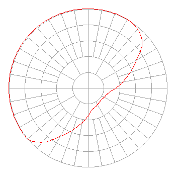 | |||||||||||||||||||||
| Azimuth | Ratio | Azimuth | Ratio | Azimuth | Ratio | Azimuth | Ratio | |||||||||||||||
| 0 | 1.000 | 10 | 1.000 | 20 | 1.000 | 30 | 1.000 | |||||||||||||||
| 40 | 0.970 | 50 | 0.895 | 60 | 0.711 | 70 | 0.565 | |||||||||||||||
| 80 | 0.449 | 90 | 0.356 | 100 | 0.283 | 110 | 0.250 | |||||||||||||||
| 120 | 0.235 | 130 | 0.225 | 140 | 0.228 | 150 | 0.241 | |||||||||||||||
| 160 | 0.258 | 170 | 0.283 | 180 | 0.356 | 190 | 0.449 | |||||||||||||||
| 200 | 0.565 | 210 | 0.711 | 220 | 0.895 | 230 | 1.000 | |||||||||||||||
| 240 | 1.000 | 250 | 1.000 | 260 | 1.000 | 270 | 1.000 | |||||||||||||||
| 280 | 1.000 | 290 | 1.000 | 300 | 1.000 | 310 | 1.000 | |||||||||||||||
| 320 | 1.000 | 330 | 1.000 | 340 | 1.000 | 350 | 1.000 | |||||||||||||||
Structure Registration Number 1306769 Structure Type: GTOWER Registered To: Cellco Partnership Structure Address: 48802 North Vulture Mine Road (15104545) Wickenburg, AZ County Name: Maricopa County ASR Issued: 02/07/2020 Date Built: 05/22/2019 Site Elevation: 816.6 m (2679 ft.) Structure Height: 150.8 m (495 ft.) Height Overall: 152.1 m (499 ft.) Overall Height AMSL: 968.7 m (3178 ft.) FAA Determination: 04/05/2018 FAA Study #: 2018-AWP-5890-OE FAA Circular #: 70/7460-1L Paint & Light FAA Chapters: 4, 8, 12 Removed expiration date from determination. Scenario 1./jjs/case#635066 33-55-21.9 N 112-47-36.3 W (NAD 83) 33-55-21.8 N 112-47-33.7 W (Converted to NAD 27) |
801 West Wickenburg Way Wickenburg, AZ 85390 Phone: 602-622-3695 Limited Liability Company | Date: 07/01/2019 Application Certifier BARNA BROADCASTING LLC 801 W. Wickenburg Way Wickenburg, AZ 85390 Applicant WILLIAM J. GETZ Carl T. Jones Corporation 7901 Yarnwood Court Springfield, VA 22153 CONSULTING ENGINEER MARISSA G. REPP, ESQ. Repp Law Firm | ||||||||||||||||||||
| ||||||||||||||||||||||