
FCCInfo.com
A Service of Cavell, Mertz & Associates, Inc.
(855) FCC-INFO
|
|
|
|
|
||||||||||||||||
|
|
W210BG Channel: 210D 89.9 MHz Ashland, Ohio Service: FX - A translator or application for a translator. Facility ID: 85385 Fac. Service: FX Programming Delivery Method: Unspecified Status: License Application Accepted: 07/28/2017 Application Granted: 08/02/2017 File Number: BLFT-20170728AER License Expires: 00/00/0000 Prefix Type: This is a license for a translator Application Type: License To Cover FCC Website Links: LMS Facility Details This Application CDBS Application Other W210BG Applications Other W210BG Applications in CDBS Including Superseded Applications Mailing Address Correspondence for W210BG Correspondence related to application BLFT-20170728AER Service Contour - Open Street Map or USGS Map (60 dBu) Service Contour - KML / Google Earth (60 dBu) Class: D, A Noncommercial educational operating with no more than 10W Site Location: 40-50-26.2 N 82-21-25.6 W (NAD 83) Site Location: 40-50-26.0 N 82-21-26.0 W (Converted to NAD 27) Effective Radiated Power: 0.08 kW Transmitter Output Power: 0.214 kW Antenna Center HAAT: 0 m Antenna Center AMSL: 404 m (1325 ft.) Antenna Center HAG: 19 m (62 ft.) Site Elevation: 385 m. (1263 ft.) Height Overall*: 87 m (285 ft.) (* As Filed In This Application, may differ from ASR Data, Below.) Directional Antenna Antenna Make/Model: None Antenna ID: 124820 Polarization:
| ||||||||||||||||||
| Antenna Data for Antenna Id: 124820 W210BG FX File: BLFT-20170728AER None - Service: FX | 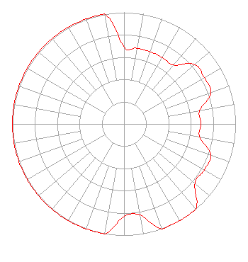 | ||||||||||||||||||
| Azimuth | Ratio | Azimuth | Ratio | Azimuth | Ratio | Azimuth | Ratio | ||||||||||||
| 0 | 0.689 | 10 | 0.689 | 20 | 0.689 | 30 | 0.689 | ||||||||||||
| 40 | 0.689 | 50 | 0.829 | 60 | 0.829 | 70 | 0.829 | ||||||||||||
| 80 | 0.689 | 90 | 0.689 | 100 | 0.689 | 110 | 0.829 | ||||||||||||
| 120 | 0.829 | 130 | 0.829 | 140 | 1.000 | 150 | 1.000 | ||||||||||||
| 160 | 1.000 | 170 | 0.829 | 180 | 0.829 | 190 | 1.000 | ||||||||||||
| 200 | 1.000 | 210 | 1.000 | 220 | 1.000 | 230 | 1.000 | ||||||||||||
| 240 | 1.000 | 250 | 1.000 | 260 | 1.000 | 270 | 1.000 | ||||||||||||
| 280 | 1.000 | 290 | 1.000 | 300 | 1.000 | 310 | 1.000 | ||||||||||||
| 320 | 1.000 | 330 | 1.000 | 340 | 1.000 | 350 | 1.000 | ||||||||||||
Structure Registration Number 1015348 Structure Type: 2TOWER Registered To: Vertical Bridge Towers, IV LLC Structure Address: 2435 Mansfield Rd Ashland, OH County Name: Ashland County ASR Issued: 10/11/2023 Date Built: 01/01/1982 Site Elevation: 385.2 m (1264 ft.) Structure Height: 86.8 m (285 ft.) Height Overall: 86.8 m (285 ft.) Overall Height AMSL: 472 m (1549 ft.) Paint & Light FAA Chapters: None 40-50-26.0 N 82-21-26.0 W (NAD 83) 40-50-25.8 N 82-21-26.4 W (Converted to NAD 27) |
11530 Carmel Commons Blvd Charlotte, NC 28226-3976 Phone: 704-523-5555 | Date: 07/28/2017 Application Certifier BIBLE BROADCASTING NETWORK, INC. 11530 Carmel Commons Boulevard Charlotte, NC 28226 Applicant JUSTIN ASHER Asher Broadcast Consulting, Llc 579 Babcock Road Bronson, MI 49028-9347 TECHNICAL CONSULTANT GARY S. SMITHWICK Smithwick & Belendiuk, P.c. 5028 Wisconsin Avenue, Nw Suite 301 Washington, DC 20016 | |||||||||||||||||