
FCCInfo.com
A Service of Cavell, Mertz & Associates, Inc.
(855) FCC-INFO
|
|
|
|
|
||||||||||||||||
|
|
W231EA Channel: 231D 94.1 MHz Buffalo, New York Service: FX - A translator or application for a translator. Facility ID: 202175 Fac. Service: FX Programming Delivery Method: Unspecified Status: License Application Accepted: 09/05/2018 Application Granted: 09/12/2018 File Number: BLFT-20180905AAN License Expires: 00/00/0000 Prefix Type: This is a license for a translator Application Type: License To Cover FCC Website Links: LMS Facility Details This Application CDBS Application Other W231EA Applications Other W231EA Applications in CDBS Including Superseded Applications Mailing Address Correspondence for W231EA Correspondence related to application BLFT-20180905AAN Service Contour - Open Street Map or USGS Map (60 dBu) Service Contour - KML / Google Earth (60 dBu) Class: D, A Noncommercial educational operating with no more than 10W Site Location: 42-38-09.2 N 78-46-06.1 W (NAD 83) Site Location: 42-38-09.0 N 78-46-07.0 W (Converted to NAD 27) Effective Radiated Power: 0.15 kW Transmitter Output Power: 0.037 kW Antenna Center HAAT: 0 m Antenna Center AMSL: 493 m (1617 ft.) Antenna Center HAG: 48 m (157 ft.) Site Elevation: 445 m. (1460 ft.) Height Overall*: 123 m (404 ft.) (* As Filed In This Application, may differ from ASR Data, Below.) Directional Antenna Antenna Make/Model: None Antenna ID: 132218 Polarization:
| ||||||||||||||||||
| Antenna Data for Antenna Id: 132218 W231EA FX File: BLFT-20180905AAN None - Service: FX | 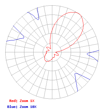 | ||||||||||||||||||
| Azimuth | Ratio | Azimuth | Ratio | Azimuth | Ratio | Azimuth | Ratio | ||||||||||||
| 0 | 0.460 | 10 | 0.696 | 20 | 0.873 | 30 | 0.975 | ||||||||||||
| 35 | 1.000 | 40 | 0.975 | 50 | 0.873 | 60 | 0.696 | ||||||||||||
| 70 | 0.460 | 80 | 0.237 | 90 | 0.086 | 100 | 0.096 | ||||||||||||
| 110 | 0.139 | 120 | 0.151 | 130 | 0.073 | 140 | 0.079 | ||||||||||||
| 150 | 0.110 | 160 | 0.125 | 170 | 0.115 | 180 | 0.148 | ||||||||||||
| 190 | 0.177 | 200 | 0.209 | 210 | 0.231 | 220 | 0.231 | ||||||||||||
| 230 | 0.209 | 240 | 0.177 | 250 | 0.148 | 260 | 0.115 | ||||||||||||
| 270 | 0.125 | 280 | 0.110 | 290 | 0.079 | 300 | 0.073 | ||||||||||||
| 310 | 0.151 | 320 | 0.139 | 330 | 0.096 | 340 | 0.086 | ||||||||||||
| 350 | 0.237 | ||||||||||||||||||
Structure Registration Number 1003498 Structure Type: GTOWER Registered To: Kimtron, Inc. Structure Address: 9001 Zimmerman Road Boston, NY County Name: Erie County ASR Issued: 05/08/2017 Date Built: 05/08/2017 Site Elevation: 445 m (1460 ft.) Structure Height: 122 m (400 ft.) Height Overall: 123 m (404 ft.) Overall Height AMSL: 568 m (1864 ft.) FAA Determination: 03/30/2017 FAA Study #: 2017-AEA-1526-OE FAA Circular #: 70/7460-1L Paint & Light FAA Chapters: 3, 4, 5, 12 PRIOR STUDY 2016-AEA-11004-OE 42-38-09.5 N 78-46-06.3 W (NAD 83) 42-38-09.3 N 78-46-07.2 W (Converted to NAD 27) |
P.o. Box 3003 Blue Bell, PA 19422 Phone: 215-628-3500 | Date: 09/05/2018 Application Certifier KIMTRON, INC. P.o. Box 3003 Blue Bell, PA 19422 Applicant W.C. ALEXANDER 2821 S. Parker Road Suite 1205 Aurora, CO 80014 DIRECTOR OF ENGINEERING JOHN NEELY, ESQ Miller And Neely Pc Suite 203 3750 University Blvd., West Kensington, MD 20895 | |||||||||||||||||