
FCCInfo.com
A Service of Cavell, Mertz & Associates, Inc.
(855) FCC-INFO
|
|
WLVH from 08/26/1987 |
|
|
||||||||||||||||
|
|
WLVH Channel: 266C2 101.1 MHz Hardeeville, South Carolina Service: FM - A full-service FM station or application. Facility ID: 31094 Fac. Service: FM Status: License 73.215 Station Application Accepted: 01/21/2014 Application Granted: 02/09/2015 File Number: BLH-20140121MLF License Expires: 00/00/0000 Prefix Type: This is a license for a commercial FM station Application Type: License To Cover FCC Website Links: LMS Facility Details This Application CDBS Application Other WLVH Applications Other WLVH Applications in CDBS Including Superseded Applications Mailing Address Correspondence for WLVH Correspondence related to application BLH-20140121MLF Service Contour - Open Street Map or USGS Map (60 dBu) Service Contour - KML / Google Earth (60 dBu) Public Inspection Files Facility Type: FM STATION Class: C2, A Zone II station; with 25kW-50kW ERP and a class contour distance 39km-52km Site Location: 32-05-47.4 N 81-19-09.1 W (NAD 83) Site Location: 32-05-46.7 N 81-19-09.7 W (Converted to NAD 27) Effective Radiated Power: 50 kW Transmitter Output Power: 27 kW Antenna Center HAAT: 144 m (472 ft.) Antenna Center AMSL: 150 m (492 ft.) Antenna Center HAG: 145 m (476 ft.) Calculated Site Elevation: 5 m. (16 ft.) Height Overall*: 154 m (505 ft.) (* As Filed In This Application, may differ from ASR Data, Below.) Directional Antenna Antenna Make/Model: Electronics Research Inc. FML-6AC-DA-SP, 6 bays, 0.5 wavelength spacing Antenna ID: 116578 Polarization: | ||||||||||||||||||
| Antenna Data for Antenna Id: 116578 WLVH FM File: BLH-20140121MLF Electronics Research Inc. - FML-6AC-DA-SP, 6 bays, 0.5 wavelength spacing Service: FM | 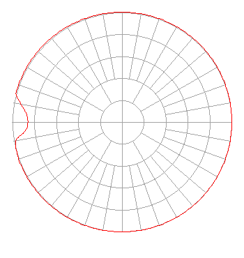 | ||||||||||||||||||
| Azimuth | Ratio | Azimuth | Ratio | Azimuth | Ratio | Azimuth | Ratio | ||||||||||||
| 0 | 1.000 | 10 | 1.000 | 20 | 1.000 | 30 | 1.000 | ||||||||||||
| 40 | 1.000 | 50 | 1.000 | 60 | 1.000 | 70 | 1.000 | ||||||||||||
| 80 | 1.000 | 90 | 1.000 | 100 | 1.000 | 110 | 1.000 | ||||||||||||
| 120 | 1.000 | 130 | 1.000 | 140 | 1.000 | 150 | 1.000 | ||||||||||||
| 160 | 1.000 | 170 | 1.000 | 180 | 1.000 | 190 | 1.000 | ||||||||||||
| 200 | 1.000 | 210 | 1.000 | 220 | 1.000 | 230 | 1.000 | ||||||||||||
| 240 | 1.000 | 250 | 1.000 | 260 | 0.980 | 265 | 0.880 | ||||||||||||
| 270 | 0.857 | 275 | 0.875 | 280 | 0.935 | 285 | 1.000 | ||||||||||||
| 290 | 1.000 | 300 | 1.000 | 310 | 1.000 | 320 | 1.000 | ||||||||||||
| 330 | 1.000 | 340 | 1.000 | 350 | 1.000 | ||||||||||||||
Structure Registration Number 1019536 Structure Type: TOWER Registered To: Pinnacle Towers LLC Structure Address: 6 Dot Barn Road Bloomingdale, GA County Name: Chatham County ASR Issued: 05/06/2016 Date Built: 08/01/1991 Site Elevation: 5.2 m (17 ft.) Structure Height: 139.8 m (459 ft.) Height Overall: 153.6 m (504 ft.) Overall Height AMSL: 158.8 m (521 ft.) FAA Determination: 05/03/2004 FAA Study #: 2004-ASO-1965-OE FAA Circular #: 70/7460-1J Paint & Light FAA Chapters: 3, 4, 5, 13 OM&L to remain the same as prior study = PAINT/RED LIGHTS 32-05-47.4 N 81-19-09.1 W (NAD 83) 32-05-46.7 N 81-19-09.7 W (Converted to NAD 27) |
7136 S. Yale Avenue Suite 501 Tulsa, OK 74136 Phone: 918-664-4581 | Date: 01/21/2014 Application Certifier CAPSTAR TX LLC 2625 S. Memorial Street, Suite A Tulsa, OK 74129 Applicant BENJAMIN BRINITZER 801 Woodridge Center Dr Charlotte, NC 28217 TECHNICAL DIRECTOR TROY LANGHAM Clear Channel | |||||||||||||||||
| |||||||||||||||||||