
FCCInfo.com
A Service of Cavell, Mertz & Associates, Inc.
(855) FCC-INFO
|
|
WWWW-FM from 07/24/2006 WWWW-FM from 10/02/2000 WWWW-FM from 02/21/1992 |
|  |
|
|||||||||||||||
|
|
WWWW-FM Channel: 275B 102.9 MHz Ann Arbor, Michigan Service: FM - A full-service FM station or application. Facility ID: 41080 Fac. Service: FM Status: License Application Accepted: 04/08/2011 Application Granted: 04/19/2011 File Number: BLH-20110408AAK License Expires: 00/00/0000 Prefix Type: This is a license for a commercial FM station Application Type: License To Cover FCC Website Links: LMS Facility Details This Application CDBS Application Other WWWW-FM Applications Other WWWW-FM Applications in CDBS Including Superseded Applications Mailing Address Correspondence for WWWW-FM Correspondence related to application BLH-20110408AAK Service Contour - Open Street Map or USGS Map (54 dBu) Service Contour - KML / Google Earth (54 dBu) Public Inspection Files History Cards for WWWW-FM Facility Type: FM STATION Class: B, A Zone I or I-A station; with 25kW-50kW ERP and a class contour distance 39km-52km Site Location: 42-14-46.1 N 83-50-57.8 W (NAD 83) Site Location: 42-14-46.0 N 83-50-58.0 W (Converted to NAD 27) Effective Radiated Power: 50 kW Transmitter Output Power: 18.64 kW Antenna Center HAAT: 134.1 m (440 ft.) Antenna Center AMSL: 406.2 m (1333 ft.) Antenna Center HAG: 116.3 m (382 ft.) Calculated Site Elevation: 289.9 m. (951 ft.) Height Overall*: 121.9 m (400 ft.) (* As Filed In This Application, may differ from ASR Data, Below.) Directional Antenna Antenna Make/Model: Electronics Research Inc. MP-4C-DA, four sections Antenna ID: 101312 Polarization: | ||||||||||||||||||
| Antenna Data for Antenna Id: 101312 WWWW-FM FM File: BLH-20110408AAK Electronics Research Inc. - MP-4C-DA, four sections Service: FM | 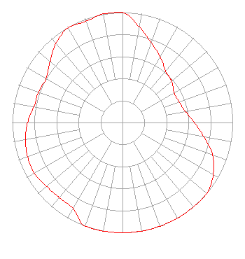 | ||||||||||||||||||
| Azimuth | Ratio | Azimuth | Ratio | Azimuth | Ratio | Azimuth | Ratio | ||||||||||||
| 0 | 1.000 | 10 | 0.880 | 20 | 0.765 | 30 | 0.685 | ||||||||||||
| 40 | 0.610 | 45 | 0.595 | 50 | 0.580 | 60 | 0.540 | ||||||||||||
| 70 | 0.545 | 80 | 0.580 | 90 | 0.650 | 100 | 0.750 | ||||||||||||
| 110 | 0.870 | 120 | 0.950 | 130 | 1.000 | 135 | 1.000 | ||||||||||||
| 140 | 1.000 | 150 | 1.000 | 160 | 1.000 | 170 | 1.000 | ||||||||||||
| 180 | 1.000 | 190 | 1.000 | 200 | 1.000 | 210 | 0.900 | ||||||||||||
| 220 | 0.890 | 225 | 0.895 | 230 | 0.900 | 240 | 0.925 | ||||||||||||
| 250 | 0.915 | 260 | 0.895 | 270 | 0.860 | 280 | 0.815 | ||||||||||||
| 290 | 0.810 | 300 | 0.800 | 310 | 0.855 | 315 | 0.898 | ||||||||||||
| 320 | 0.940 | 330 | 0.990 | 340 | 0.975 | 350 | 1.000 | ||||||||||||
Structure Registration Number 1275265 Structure Type: GTOWER Registered To: SBA Towers II LLC Structure Address: 6634 W. Waters Rd. (mi12555-s) Ann Arbor, MI County Name: Washtenaw County ASR Issued: 05/19/2017 Date Built: 03/30/2011 Site Elevation: 290 m (951 ft.) Structure Height: 120 m (394 ft.) Height Overall: 121.9 m (400 ft.) Overall Height AMSL: 411.9 m (1351 ft.) FAA Determination: 05/15/2017 FAA Study #: 2017-AGL-6426-OE FAA Circular #: 70/7460-1L Paint & Light FAA Chapters: 4, 8, 12 PRIOR STUDY 2010-AGL-2771-OE 42-14-46.5 N 83-50-58.0 W (NAD 83) 42-14-46.4 N 83-50-58.2 W (Converted to NAD 27) |
780 Johnson Ferry Road Suite 500 Atlanta, GA 30342 Phone: 404-949-0700 Limited Liability Company | Date: 04/08/2011 Application Certifier CUMULUS LICENSING LLC 3280 Peachtree Road, Nw Suite 2200 Atlanta, GA 30305 Applicant JEFFERSON G. BROCK Graham Brock, Inc. P. O. Box 24466 St. Simons Island, GA 31522-7466 TECHNICAL CONSULTANT MARK N. LIPP, ESQ. Wiley Rein Llp | |||||||||||||||||
| |||||||||||||||||||