
FCCInfo.com
A Service of Cavell, Mertz & Associates, Inc.
(855) FCC-INFO
|
|
KALC from 05/16/1994 KALC from 08/25/1988 |
|
|
||||||||||||||||||||||
|
|
KALC Channel: 290C 105.9 MHz Denver, Colorado Service: FS - A full service FM station auxiliary transmitting antenna or application. Facility ID: 59601 Fac. Service: FM Analog & Digital Status: License Application Accepted: 10/20/2010 Application Granted: 11/10/2010 File Number: BXLH-20101020AAI License Expires: 00/00/0000 Prefix Type: This is BXLH Application Type: License To Cover FCC Website Links: LMS Facility Details This Application CDBS Application Other KALC Applications Other KALC Applications in CDBS Including Superseded Applications Mailing Address Correspondence for KALC Correspondence related to application BXLH-20101020AAI Service Contour - Open Street Map or USGS Map (60 dBu) Service Contour - KML / Google Earth (60 dBu) Public Inspection Files History Cards for KALC Facility Type: FM STATION Class: C, A Zone II station; with exactly 100kW ERP and a class contour distance 72km-92km Site Location: 39-43-59.0 N 105-14-12.0 W (NAD 83) Site Location: 39-43-59.0 N 105-14-10.0 W (Converted to NAD 27) Effective Radiated Power: 25 kW Transmitter Output Power: 4 kW Antenna Center HAAT: 487 m (1598 ft.) Antenna Center AMSL: 2256 m (7402 ft.) Antenna Center HAG: 49 m (161 ft.) Calculated Site Elevation: 2207 m. (7241 ft.) Height Overall*: 58 m (190 ft.) (* As Filed In This Application, may differ from ASR Data, Below.) Directional Antenna Antenna Make/Model: Electronics Research Inc. 1082-8CP-DA Antenna ID: 98952 Polarization: | ||||||||||||||||||||||||
| Antenna Data for Antenna Id: 98952 KALC FS File: BXLH-20101020AAI Electronics Research Inc. - 1082-8CP-DA Service: FS | 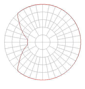 | ||||||||||||||||||||||||
| Azimuth | Ratio | Azimuth | Ratio | Azimuth | Ratio | Azimuth | Ratio | ||||||||||||||||||
| 0 | 1.000 | 10 | 1.000 | 20 | 1.000 | 30 | 1.000 | ||||||||||||||||||
| 40 | 1.000 | 50 | 1.000 | 60 | 1.000 | 70 | 1.000 | ||||||||||||||||||
| 80 | 1.000 | 90 | 1.000 | 100 | 1.000 | 110 | 1.000 | ||||||||||||||||||
| 120 | 1.000 | 130 | 1.000 | 140 | 1.000 | 150 | 1.000 | ||||||||||||||||||
| 160 | 1.000 | 170 | 1.000 | 180 | 1.000 | 190 | 1.000 | ||||||||||||||||||
| 200 | 1.000 | 210 | 1.000 | 220 | 1.000 | 230 | 0.794 | ||||||||||||||||||
| 240 | 0.631 | 250 | 0.501 | 260 | 0.398 | 270 | 0.398 | ||||||||||||||||||
| 280 | 0.398 | 290 | 0.501 | 300 | 0.631 | 310 | 0.794 | ||||||||||||||||||
| 320 | 1.000 | 330 | 1.000 | 340 | 1.000 | 350 | 1.000 | ||||||||||||||||||
Structure Registration Number 1033691 Structure Type: TOWER Registered To: Vertical Bridge CC FM, LLC Structure Address: Lookout Mountain Golden, CO County Name: Jefferson County ASR Issued: 11/08/2018 Date Built: 03/11/1986 Site Elevation: 2206.8 m (7240 ft.) Structure Height: 58.4 m (192 ft.) Height Overall: 58.4 m (192 ft.) Overall Height AMSL: 2265.2 m (7432 ft.) FAA Determination: 09/19/1997 FAA Study #: 97-ANM-1008-OE Paint & Light FAA Chapters: NONE 39-43-59.0 N 105-14-12.0 W (NAD 83) 39-43-59.0 N 105-14-10.0 W (Converted to NAD 27) |
2400 Market Street 4th Floor Philadelphia, PA 19103 Phone: 610-660-5610 Limited Liability Company | Date: 10/20/2010 Application Certifier ENTERCOM DENVER LICENSE, LLC 401 City Avenue Suite 809 Bala Cynwyd, PA 19004 Applicant JOHN W. PRICE Entercom Corporate Engineering 1100 Olive Way, Suite 1650 Seattle, WA 98101 ASS'T TO VP-TECHNOLOGY CARRIE A. WARD, ESQ. Entercom Communications Corp. | |||||||||||||||||||||||
|
| ||||||||||||||||||||||||