
FCCInfo.com
A Service of Cavell, Mertz & Associates, Inc.
(855) FCC-INFO
|
|
WBKG from 05/16/1995 |
|  |
|
|||||||||||||||
|
|
WBKG Channel: 205C3 88.9 MHz Macon, Georgia Service: FM - A full-service FM station or application. Facility ID: 76358 Fac. Service: FM Status: License Application Accepted: 05/10/2005 Application Granted: 08/04/2005 File Number: BLED-20050510ABV License Expires: 00/00/0000 Prefix Type: This is a license for a noncommercial educational FM station Application Type: License To Cover FCC Website Links: LMS Facility Details This Application CDBS Application Other WBKG Applications Other WBKG Applications in CDBS Including Superseded Applications Mailing Address Correspondence for WBKG Correspondence related to application BLED-20050510ABV Service Contour - Open Street Map or USGS Map (60 dBu) Service Contour - KML / Google Earth (60 dBu) Public Inspection Files Facility Type: NON-COMMERCIAL EDUC. FM Class: C3, A Zone II station; with 6kW-25kW ERP and a class contour distance 28km-39km Site Location: 32-45-51.5 N 83-33-31.7 W (NAD 83) Site Location: 32-45-51.0 N 83-33-32.0 W (Converted to NAD 27) Effective Radiated Power: 5.5 kW Transmitter Output Power: 1.13 kW Antenna Center HAAT: 153 m (502 ft.) Antenna Center AMSL: 264 m (866 ft.) Antenna Center HAG: 113 m (371 ft.) Site Elevation: 151 m. (495 ft.) Height Overall*: 194 m (636 ft.) (* As Filed In This Application, may differ from ASR Data, Below.) Directional Antenna Antenna Make/Model: Shivley 6810-6DA, six sections Antenna ID: 68889 Polarization:
| ||||||||||||||||||
| Antenna Data for Antenna Id: 68889 WBKG FM File: BLED-20050510ABV Shivley - 6810-6DA, six sections Service: FM | 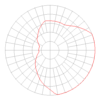 | ||||||||||||||||||
| Azimuth | Ratio | Azimuth | Ratio | Azimuth | Ratio | Azimuth | Ratio | ||||||||||||
| 0 | 0.650 | 10 | 0.650 | 20 | 0.650 | 30 | 0.650 | ||||||||||||
| 40 | 0.700 | 45 | 0.750 | 50 | 0.800 | 60 | 0.900 | ||||||||||||
| 70 | 1.000 | 80 | 1.000 | 90 | 1.000 | 100 | 1.000 | ||||||||||||
| 110 | 1.000 | 120 | 1.000 | 130 | 1.000 | 135 | 1.000 | ||||||||||||
| 140 | 1.000 | 150 | 1.000 | 160 | 1.000 | 170 | 1.000 | ||||||||||||
| 180 | 0.875 | 190 | 0.775 | 200 | 0.675 | 210 | 0.575 | ||||||||||||
| 220 | 0.500 | 225 | 0.463 | 230 | 0.425 | 240 | 0.350 | ||||||||||||
| 250 | 0.300 | 260 | 0.250 | 270 | 0.250 | 280 | 0.250 | ||||||||||||
| 290 | 0.250 | 300 | 0.300 | 310 | 0.375 | 315 | 0.400 | ||||||||||||
| 320 | 0.425 | 330 | 0.500 | 340 | 0.575 | 350 | 0.650 | ||||||||||||
Structure Registration Number 1045776 [ASR Heights Differ from WBKG Application] Structure Type: GTOWER Registered To: Macon Urban Ministries, Inc Structure Address: 5950 Ocmulgee East Blvd (9at0619e) Macon, GA County Name: Bibb County ASR Issued: 07/12/2023 Date Built: 06/02/1999 Site Elevation: 147.2 m (483 ft.) Structure Height: 192 m (630 ft.) Height Overall: 194.2 m (637 ft.) Overall Height AMSL: 341.4 m (1120 ft.) FAA Determination: 06/15/2023 FAA Study #: 2022-ASO-39227-OE FAA Circular #: 70/7460-1M Paint & Light FAA Chapters: 4, 8, 15 PRIOR STUDY 1997-ASO-6564-OE 32-45-55.2 N 83-33-32.1 W (NAD 83) 32-45-54.7 N 83-33-32.4 W (Converted to NAD 27) |
P.o. Drawer 2440 Tupelo, MS 38801-2440 Phone: 662-844-8888 Not-for-Profit | Date: 05/10/2005 Application Certifier AMERICAN FAMILY ASSOCIATION Great Lakes Broadcast Academy, Inc. P.o. Drawer 2440 Tupelo, MS 38801 Applicant MARSHA SHRADER American Family Association P.o. Drawer 2440 Tupelo, MS 38803 TECHNICAL CONSULTANT MARSHA SHRADER American Family Association | |||||||||||||||||