
FCCInfo.com
A Service of Cavell, Mertz & Associates, Inc.
(855) FCC-INFO
|
|
|
|
|
||||||||||||||||
|
|
W249BN Channel: 249D 97.7 MHz Memphis, Tennessee Service: FX - A translator or application for a translator. Facility ID: 139990 Fac. Service: FX Programming Delivery Method: Unspecified Status: License Application Accepted: 07/01/2013 Application Granted: 08/22/2013 File Number: BLFT-20130701ABK License Expires: 00/00/0000 Prefix Type: This is a license for a translator Application Type: License To Cover FCC Website Links: LMS Facility Details This Application CDBS Application Other W249BN Applications Other W249BN Applications in CDBS Including Superseded Applications Mailing Address Correspondence for W249BN Correspondence related to application BLFT-20130701ABK Service Contour - Open Street Map or USGS Map (60 dBu) Service Contour - KML / Google Earth (60 dBu) Class: D, A Noncommercial educational operating with no more than 10W Site Location: 35-12-34.3 N 89-49-01.3 W (NAD 83) Site Location: 35-12-34.0 N 89-49-01.0 W (Converted to NAD 27) Effective Radiated Power: 0.22 kW Transmitter Output Power: 0.83 kW Antenna Center HAAT: 223.4 m Horiz.; 0 m Vert. Antenna Center AMSL: 313 m (1027 ft.) Antenna Center HAG: 229 m (751 ft.) Site Elevation: 84 m. (276 ft.) Height Overall*: 276 m (906 ft.) (* As Filed In This Application, may differ from ASR Data, Below.) Directional Antenna Antenna Make/Model: None Antenna ID: 112459 Polarization:
| ||||||||||||||||||
| Antenna Data for Antenna Id: 112459 W249BN FX File: BLFT-20130701ABK None - Service: FX | 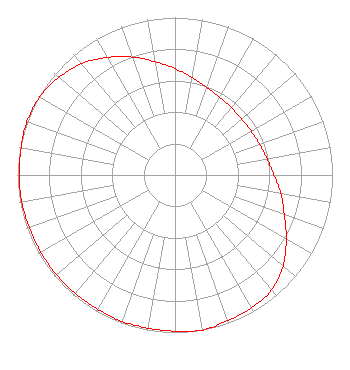 | ||||||||||||||||||
| Azimuth | Ratio | Azimuth | Ratio | Azimuth | Ratio | Azimuth | Ratio | ||||||||||||
| 0 | 0.676 | 10 | 0.628 | 20 | 0.594 | 30 | 0.571 | ||||||||||||
| 40 | 0.558 | 50 | 0.553 | 60 | 0.558 | 70 | 0.571 | ||||||||||||
| 80 | 0.594 | 90 | 0.628 | 100 | 0.682 | 110 | 0.738 | ||||||||||||
| 120 | 0.815 | 130 | 0.897 | 140 | 0.953 | 150 | 0.973 | ||||||||||||
| 160 | 0.983 | 170 | 1.000 | 180 | 0.992 | 190 | 0.988 | ||||||||||||
| 200 | 0.988 | 210 | 0.983 | 220 | 0.983 | 230 | 0.983 | ||||||||||||
| 240 | 0.983 | 250 | 0.983 | 260 | 0.988 | 270 | 0.988 | ||||||||||||
| 280 | 0.992 | 290 | 1.000 | 300 | 0.991 | 310 | 0.963 | ||||||||||||
| 320 | 0.923 | 330 | 0.862 | 340 | 0.797 | 350 | 0.731 | ||||||||||||
Structure Registration Number 1249321 Structure Type: Registered To: RADIANT LIFE MINISTRIES. INC. Structure Address: 3145 Bartlett Corp Drive Bartlett, TN County Name: Shelby County ASR Issued: 06/10/2021 Date Built: 04/01/2008 Site Elevation: 84.4 m (277 ft.) Structure Height: 274.3 m (900 ft.) Height Overall: 275.8 m (905 ft.) Overall Height AMSL: 360.2 m (1182 ft.) FAA Determination: 04/19/2005 FAA Study #: 2005-ASO-139-OE FAA Circular #: 70/7460-1K Paint & Light FAA Chapters: 3, 4, 5, 12 Removed expiration and final dates from determination. Scenario 2./jjs/case#635066 35-12-34.3 N 89-49-01.4 W (NAD 83) 35-12-34.0 N 89-49-01.1 W (Converted to NAD 27) |
6080 Mt. Moriah Ext. Memphis, TN 38115 Phone: 901-375-9324 | Date: 07/01/2013 Application Certifier FLINN BROADCASTING CORPORATION 6080 Mt. Moriah Ext. Memphis, TN 38115 Applicant W. JEFFREY REYNOLDS Du Treil, Lundin & Rackley, Inc. 201 Fletcher Avenue Sarasota, FL 34237-6019 TECHNICAL CONSULTANT STEPHEN C. SIMPSON Attorney At Law 1250 Connecticut Avenue, N.w. Suite 200 Washington, DC 20036 | |||||||||||||||||