
FCCInfo.com
A Service of Cavell, Mertz & Associates, Inc.
(855) FCC-INFO
|
|
W295BY from 12/05/2013 |
|
|
||||||||||||||||
|
|
W295BY Channel: 295D 106.9 MHz Elmira, New York Service: FX - A translator or application for a translator. Facility ID: 141410 Fac. Service: FX Programming Delivery Method: Unspecified Status: License Application Accepted: 07/20/2016 Application Granted: 08/01/2016 File Number: BLFT-20160720ABC License Expires: 00/00/0000 Prefix Type: This is a license for a translator Application Type: License To Cover FCC Website Links: LMS Facility Details This Application CDBS Application Other W295BY Applications Other W295BY Applications in CDBS Including Superseded Applications Mailing Address Correspondence for W295BY Correspondence related to application BLFT-20160720ABC Service Contour - Open Street Map or USGS Map (60 dBu) Service Contour - KML / Google Earth (60 dBu) Class: D, A Noncommercial educational operating with no more than 10W Site Location: 42-01-55.0 N 76-47-01.0 W (NAD 83) Site Location: 42-01-54.7 N 76-47-02.2 W (Converted to NAD 27) Effective Radiated Power: 0 kW Horiz. ; 0.09 kW Vert. Transmitter Output Power: 0.053 kW Antenna Center HAAT: 0 m Antenna Center AMSL: 0 m Horiz.; 574 m Vert. Antenna Center HAG: 0 m Horiz.; 35 m Vert. Site Elevation: 539 m. (1768 ft.) Height Overall*: 98 m (322 ft.) (* As Filed In This Application, may differ from ASR Data, Below.) Directional Antenna Antenna Make/Model: None Antenna ID: 16130 Polarization:
| ||||||||||||||||||
| Antenna Data for Antenna Id: 16130 W295BY FX File: BLFT-20160720ABC None - Service: FX | 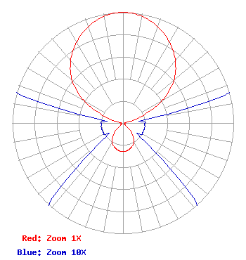 | ||||||||||||||||||
| Azimuth | Ratio | Azimuth | Ratio | Azimuth | Ratio | Azimuth | Ratio | ||||||||||||
| 0 | 1.000 | 10 | 0.980 | 20 | 0.923 | 30 | 0.840 | ||||||||||||
| 40 | 0.735 | 50 | 0.600 | 60 | 0.410 | 70 | 0.185 | ||||||||||||
| 80 | 0.030 | 90 | 0.020 | 100 | 0.020 | 110 | 0.020 | ||||||||||||
| 120 | 0.020 | 130 | 0.025 | 140 | 0.125 | 150 | 0.195 | ||||||||||||
| 160 | 0.230 | 170 | 0.250 | 180 | 0.260 | 190 | 0.250 | ||||||||||||
| 200 | 0.230 | 210 | 0.195 | 220 | 0.125 | 230 | 0.025 | ||||||||||||
| 240 | 0.020 | 250 | 0.020 | 260 | 0.020 | 270 | 0.020 | ||||||||||||
| 280 | 0.030 | 290 | 0.185 | 300 | 0.410 | 310 | 0.600 | ||||||||||||
| 320 | 0.735 | 330 | 0.840 | 340 | 0.923 | 350 | 0.980 | ||||||||||||
Structure Registration Number 1006946 [ASR Heights Differ from W295BY Application] Structure Type: GTOWER Registered To: T & K Communications Systems, Inc Structure Address: Comfort Hill Rd Elmira, NY County Name: Chemung County ASR Issued: 05/13/2022 Date Built: 07/01/1984 Site Elevation: 538.6 m (1767 ft.) Structure Height: 91.4 m (300 ft.) Height Overall: 97.5 m (320 ft.) Overall Height AMSL: 636.1 m (2087 ft.) FAA Determination: 03/21/2014 FAA Study #: 2013-AEA-4608-OE FAA Circular #: 70/7460-1K Paint & Light FAA Chapters: 4, 8, 12 PRIOR STUDY 1984-AEA-1603-OE 42-01-55.0 N 76-47-01.0 W (NAD 83) 42-01-54.7 N 76-47-02.2 W (Converted to NAD 27) |
115 West Main Street Frankfort, KY 40601 Phone: 502-875-1130 Limited Liability Company | Date: 07/20/2016 Application Certifier SOUND COMMUNICATIONS, LLC C/o Paige P. Christian 21 East Market Street, Suite 101 Corning, NY 14830 Applicant JAMES L TRAVIS 12372 Huckleberry Ct Rancho Cucamonga, CA 91739 CONSULTANT MARK B. DENBO Smithwick & Belendiuk, P.c. 5028 Wisconsin Avenue, N.w. Suite 301 Washington, DC 20016 | |||||||||||||||||