
FCCInfo.com
A Service of Cavell, Mertz & Associates, Inc.
(855) FCC-INFO
|
|
WWDL from 08/17/1998 |
|  |
|
|||||||||||||||
|
|
WWDL Channel: 217A 91.3 MHz Plainfield, Indiana Service: FM - A full-service FM station or application. Facility ID: 91476 Fac. Service: FM Status: License Application Accepted: 01/06/2016 Application Granted: 01/21/2016 File Number: BLED-20160106AAG License Expires: 00/00/0000 Prefix Type: This is a license for a noncommercial educational FM station Application Type: License To Cover FCC Website Links: LMS Facility Details This Application CDBS Application Other WWDL Applications Other WWDL Applications in CDBS Including Superseded Applications Mailing Address Correspondence for WWDL Correspondence related to application BLED-20160106AAG Service Contour - Open Street Map or USGS Map (60 dBu) Service Contour - KML / Google Earth (60 dBu) Public Inspection Files Facility Type: NON-COMMERCIAL EDUC. FM Class: A, A Zone I; I-A; or II station; with 0.1kW-6kW ERP and a class contour distance <=28km Site Location: 39-40-18.2 N 86-21-30.0 W (NAD 83) Site Location: 39-40-18.0 N 86-21-30.0 W (Converted to NAD 27) Effective Radiated Power: 0.295 kW Transmitter Output Power: 0.443 kW Antenna Center HAAT: 43 m (141 ft.) Antenna Center AMSL: 275 m (902 ft.) Antenna Center HAG: 39 m (128 ft.) Calculated Site Elevation: 236 m. (774 ft.) Height Overall*: 49.7 m (163 ft.) (* As Filed In This Application, may differ from ASR Data, Below.) Directional Antenna Antenna Make/Model: Electronics Research Inc. LP-1E-DA Antenna ID: 122498 Polarization:
| ||||||||||||||||||
| Antenna Data for Antenna Id: 122498 WWDL FM File: BLED-20160106AAG Electronics Research Inc. - LP-1E-DA Service: FM | 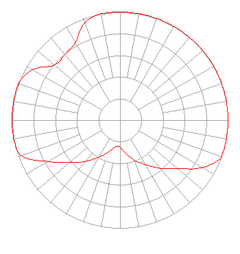 | ||||||||||||||||||
| Azimuth | Ratio | Azimuth | Ratio | Azimuth | Ratio | Azimuth | Ratio | ||||||||||||
| 0 | 1.000 | 10 | 1.000 | 20 | 1.000 | 30 | 1.000 | ||||||||||||
| 40 | 1.000 | 50 | 1.000 | 60 | 1.000 | 70 | 1.000 | ||||||||||||
| 80 | 1.000 | 90 | 1.000 | 100 | 1.000 | 110 | 1.000 | ||||||||||||
| 120 | 0.877 | 130 | 0.697 | 140 | 0.582 | 150 | 0.474 | ||||||||||||
| 160 | 0.396 | 170 | 0.314 | 180 | 0.250 | 190 | 0.250 | ||||||||||||
| 200 | 0.314 | 210 | 0.396 | 220 | 0.499 | 230 | 0.609 | ||||||||||||
| 240 | 0.767 | 250 | 0.966 | 260 | 1.000 | 270 | 1.000 | ||||||||||||
| 280 | 1.000 | 290 | 1.000 | 300 | 0.933 | 310 | 0.791 | ||||||||||||
| 320 | 0.793 | 330 | 0.829 | 340 | 0.956 | 350 | 1.000 | ||||||||||||
Structure Registration Number 1054815 [ASR Heights Differ from WWDL Application] Structure Type: MTOWER Registered To: American Towers LLC Structure Address: 10399 Reeves Road (i-70 & Six Points Rd. # 91640) Plainfield, IN County Name: Hendricks County ASR Issued: 10/27/2022 Date Built: 11/22/2010 Site Elevation: 235 m (771 ft.) Structure Height: 48.8 m (160 ft.) Height Overall: 49.7 m (163 ft.) Overall Height AMSL: 284.7 m (934 ft.) FAA Determination: 10/18/2022 FAA Study #: 2021-AGL-27979-OE Paint & Light FAA Chapters: NONE PRIOR STUDY 2018-AGL-420-OE 39-40-18.3 N 86-21-30.2 W (NAD 83) 39-40-18.1 N 86-21-30.2 W (Converted to NAD 27) |
106 Assembly Drive Piedmont, SC 29673 Phone: 864-676-2171 Not-for-Profit | Date: 01/06/2016 Application Certifier THE POWER FOUNDATION 106 Assembly Drive Piedmont, SC 29673 Applicant PAUL LIERMAN P.o. Box 18 Penney Farms, FL 32079 TECHNICAL CONSULTANT JOHN C. TRENT, ESQ. Putbrese Hunsaker & Trent, P.c. | |||||||||||||||||