
FCCInfo.com
A Service of Cavell, Mertz & Associates, Inc.
(855) FCC-INFO
|
|
W234AX from 03/11/2009 W234AX from 02/18/2009 W234AX from 06/24/2008 W234AX from 01/29/2008 W234AX from 06/25/2007 W234AX from 06/29/2004 |
|
|
||||||||||||||||
|
|
W234AX Channel: 234D 94.7 MHz Allentown, Pennsylvania Service: FX - A translator or application for a translator. Facility ID: 157407 Fac. Service: FX Programming Delivery Method: Unspecified Status: License Application Accepted: 09/21/2009 Application Granted: 10/01/2009 File Number: BLFT-20090921ADU License Expires: 00/00/0000 Prefix Type: This is a license for a translator Application Type: License To Cover FCC Website Links: LMS Facility Details This Application CDBS Application Other W234AX Applications Other W234AX Applications in CDBS Including Superseded Applications Mailing Address Correspondence for W234AX Correspondence related to application BLFT-20090921ADU Service Contour - Open Street Map or USGS Map (60 dBu) Service Contour - KML / Google Earth (60 dBu) Class: D, A Noncommercial educational operating with no more than 10W Site Location: 40-35-55.4 N 75-25-10.7 W (NAD 83) Site Location: 40-35-55.0 N 75-25-12.0 W (Converted to NAD 27) Effective Radiated Power: 0.01 kW Transmitter Output Power: 0.017 kW Antenna Center HAAT: 204.9 m Horiz.; 0 m Vert. Antenna Center AMSL: 344 m (1129 ft.) Antenna Center HAG: 82 m (269 ft.) Site Elevation: 262 m. (860 ft.) Height Overall*: 96 m (315 ft.) (* As Filed In This Application, may differ from ASR Data, Below.) Directional Antenna Antenna Make/Model: None Antenna ID: 94106 Polarization:
| ||||||||||||||||||
| Antenna Data for Antenna Id: 94106 W234AX FX File: BLFT-20090921ADU None - Service: FX | 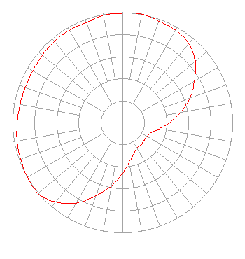 | ||||||||||||||||||
| Azimuth | Ratio | Azimuth | Ratio | Azimuth | Ratio | Azimuth | Ratio | ||||||||||||
| 0 | 0.991 | 10 | 0.999 | 20 | 0.977 | 30 | 0.966 | ||||||||||||
| 40 | 0.934 | 50 | 0.862 | 60 | 0.754 | 70 | 0.653 | ||||||||||||
| 80 | 0.536 | 90 | 0.430 | 100 | 0.339 | 110 | 0.275 | ||||||||||||
| 120 | 0.255 | 130 | 0.254 | 140 | 0.265 | 150 | 0.265 | ||||||||||||
| 160 | 0.302 | 170 | 0.362 | 180 | 0.463 | 190 | 0.585 | ||||||||||||
| 200 | 0.708 | 210 | 0.844 | 220 | 0.942 | 230 | 1.000 | ||||||||||||
| 240 | 0.995 | 250 | 0.982 | 260 | 0.971 | 270 | 0.954 | ||||||||||||
| 280 | 0.943 | 290 | 0.938 | 300 | 0.938 | 310 | 0.948 | ||||||||||||
| 320 | 0.959 | 330 | 0.965 | 340 | 0.963 | 350 | 0.987 | ||||||||||||
Structure Registration Number 1026723 [ASR Heights Differ from W234AX Application] Structure Type: LTOWER Registered To: SERVICE ELECTRIC CABLE TV, INC. Structure Address: One Mile East Of Salisbury Twp., Pa 18015 Salisbury Twp., PA County Name: Lehigh County ASR Issued: 04/04/2024 Date Built: 03/01/1991 Site Elevation: 253 m (830 ft.) Structure Height: 99 m (325 ft.) Height Overall: 99 m (325 ft.) Overall Height AMSL: 352 m (1155 ft.) FAA Determination: 03/25/2024 FAA Study #: 2024-AEA-1408-OE FAA Circular #: 70/7460-1M Paint & Light FAA Chapters: 4, 8, 15 PRIOR STUDY 2023-AEA-14936-OE 40-35-55.7 N 75-25-07.6 W (NAD 83) 40-35-55.3 N 75-25-08.9 W (Converted to NAD 27) |
3280 Peachtree Road, Nw Suite 2200 Atlanta, GA 30305 Phone: 404-949-0700 | Date: 09/21/2009 Application Certifier FAMILY LIFE MINISTRIES, INC Po Box 506 Bath, NY 14810 Applicant JAMES L TRAVIS Po Box 506 Bath, NY 14810 CHIEF ENGINEER FAMILY LIFE MINISTRIES, INC Family Life Ministries, Inc Po Box 506 Bath, NY 14810 | |||||||||||||||||