
FCCInfo.com
A Service of Cavell, Mertz & Associates, Inc.
(855) FCC-INFO
|
|
|
|
|
||||||||||||||||
|
|
W233BC Channel: 233D 94.5 MHz Ashland, Pennsylvania Service: FX - A translator or application for a translator. Facility ID: 157311 Fac. Service: FX Programming Delivery Method: Unspecified Status: License Application Accepted: 08/13/2007 Application Granted: 08/27/2007 File Number: BLFT-20070813AAM License Expires: 00/00/0000 Prefix Type: This is a license for a translator Application Type: License To Cover FCC Website Links: LMS Facility Details This Application CDBS Application Other W233BC Applications Other W233BC Applications in CDBS Including Superseded Applications Mailing Address Correspondence for W233BC Correspondence related to application BLFT-20070813AAM Service Contour - Open Street Map or USGS Map (60 dBu) Service Contour - KML / Google Earth (60 dBu) Class: D, A Noncommercial educational operating with no more than 10W Site Location: 40-46-24.3 N 76-21-14.8 W (NAD 83) Site Location: 40-46-24.0 N 76-21-16.0 W (Converted to NAD 27) Effective Radiated Power: 0 kW Horiz. ; 0.01 kW Vert. Transmitter Output Power: 0.01 kW Antenna Center HAAT: 0 m Horiz.; 154.6 m Vert. Antenna Center AMSL: 0 m Horiz.; 534 m Vert. Antenna Center HAG: 0 m Horiz.; 60 m Vert. Site Elevation: 474 m. (1555 ft.) Height Overall*: 106 m (348 ft.) (* As Filed In This Application, may differ from ASR Data, Below.) Directional Antenna Antenna Make/Model: None Antenna ID: 31326 Polarization:
| ||||||||||||||||||
| Antenna Data for Antenna Id: 31326 W233BC FX File: BLFT-20070813AAM None - Service: FX | 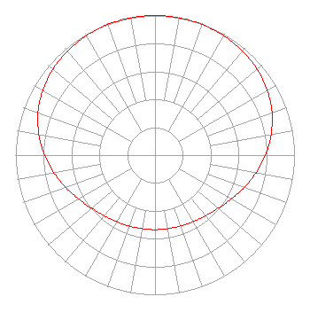 | ||||||||||||||||||
| Azimuth | Ratio | Azimuth | Ratio | Azimuth | Ratio | Azimuth | Ratio | ||||||||||||
| 0 | 1.000 | 10 | 0.999 | 20 | 0.995 | 30 | 0.987 | ||||||||||||
| 40 | 0.975 | 50 | 0.956 | 60 | 0.929 | 70 | 0.892 | ||||||||||||
| 80 | 0.845 | 90 | 0.792 | 100 | 0.735 | 110 | 0.679 | ||||||||||||
| 120 | 0.630 | 130 | 0.592 | 140 | 0.566 | 150 | 0.549 | ||||||||||||
| 160 | 0.540 | 170 | 0.535 | 180 | 0.534 | 190 | 0.535 | ||||||||||||
| 200 | 0.540 | 210 | 0.549 | 220 | 0.566 | 230 | 0.592 | ||||||||||||
| 240 | 0.630 | 250 | 0.679 | 260 | 0.735 | 270 | 0.792 | ||||||||||||
| 280 | 0.845 | 290 | 0.892 | 300 | 0.929 | 310 | 0.956 | ||||||||||||
| 320 | 0.975 | 330 | 0.987 | 340 | 0.995 | 350 | 0.999 | ||||||||||||
Structure Registration Number 1231521 Structure Type: TOWER Registered To: Jordan Realty, Inc. Structure Address: Hilltop South End Of Brough Of Ashland Ashland, PA County Name: Schuylkill County ASR Issued: 12/24/2001 Date Built: 02/01/2001 Site Elevation: 474.2 m (1556 ft.) Structure Height: 100.3 m (329 ft.) Height Overall: 106.1 m (348 ft.) Overall Height AMSL: 580.3 m (1904 ft.) FAA Determination: 11/27/2001 FAA Study #: 01-AEA-2870-OE FAA Circular #: 70/7460-1K Paint & Light FAA Chapters: 4, 6, 12 Removed expiration date from determination. Scenario 1./jjs/case#635066 40-46-24.0 N 76-21-15.1 W (NAD 83) 40-46-23.7 N 76-21-16.3 W (Converted to NAD 27) |
1186 Sumneytown Pike Harleysville, PA 19438 Phone: 215-721-2141 | Date: 08/13/2007 Application Certifier FOUR RIVERS COMMUNITY BROADCASTING CORPORATION P.o. Box 186 Sellersville, PA 18960 Applicant CHARLES W. LOUGHERY Po Box 186 Sellersville, PA 18960 PRESIDENT/DIRECTOR OF ENGINEERING MALCOLM G. STEVENSON Schwartz, Woods & Miller Suite 610, The Lion Building 1233 20th Street Nw Washington, DC 20036-7322 | |||||||||||||||||