
FCCInfo.com
A Service of Cavell, Mertz & Associates, Inc.
(855) FCC-INFO
|
|
KLMP-FM1 from 01/25/2005 KLMP-FM1 from 08/12/2004 |
|
|
||||||||||||||||
|
|
KLMP-FM1 Channel: 202D 88.3 MHz Rapid City, South Dakota Service: FB - A booster station or application for a booster. Facility ID: 161655 Fac. Service: FB Programming Delivery Method: Unspecified Status: License Application Accepted: 09/06/2005 Application Granted: 11/30/2005 File Number: BLFTB-20050906ACM License Expires: 00/00/0000 Prefix Type: This is a license for a booster Application Type: License To Cover FCC Website Links: LMS Facility Details This Application CDBS Application Other KLMP-FM1 Applications Other KLMP-FM1 Applications in CDBS Including Superseded Applications Mailing Address Correspondence for KLMP-FM1 Correspondence related to application BLFTB-20050906ACM Service Contour - Open Street Map or USGS Map (60 dBu) Service Contour - KML / Google Earth (60 dBu) Facility Type: NON-COMMERCIAL EDUC. FM Class: D, A Noncommercial educational operating with no more than 10W Site Location: 44-05-33.0 N 103-14-54.7 W (NAD 83) Site Location: 44-05-33.0 N 103-14-53.0 W (Converted to NAD 27) Effective Radiated Power: 2.3 kW Transmitter Output Power: 1.19 kW Antenna Center HAAT: 0 m Antenna Center AMSL: 1198 m (3930 ft.) Antenna Center HAG: 52 m (171 ft.) Site Elevation: 1146 m. (3760 ft.) Height Overall*: 163 m (535 ft.) (* As Filed In This Application, may differ from ASR Data, Below.) Directional Antenna Antenna Make/Model: None Antenna ID: 65601 Polarization:
| ||||||||||||||||||
| Antenna Data for Antenna Id: 65601 KLMP-FM1 FB File: BLFTB-20050906ACM None - Service: FB Pattern and Field Values Include a 235° Clockwise Rotation | 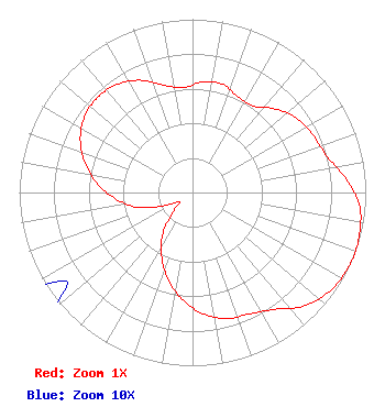 | ||||||||||||||||||
| Azimuth | Ratio | Azimuth | Ratio | Azimuth | Ratio | Azimuth | Ratio | ||||||||||||
| 5 | 0.639 | 15 | 0.649 | 25 | 0.613 | 35 | 0.611 | ||||||||||||
| 45 | 0.682 | 55 | 0.741 | 65 | 0.771 | 75 | 0.803 | ||||||||||||
| 85 | 0.890 | 95 | 0.969 | 105 | 0.994 | 110 | 1.000 | ||||||||||||
| 115 | 0.998 | 125 | 0.978 | 135 | 0.923 | 145 | 0.824 | ||||||||||||
| 155 | 0.774 | 165 | 0.753 | 175 | 0.702 | 185 | 0.624 | ||||||||||||
| 195 | 0.528 | 205 | 0.419 | 215 | 0.303 | 225 | 0.160 | ||||||||||||
| 235 | 0.089 | 245 | 0.183 | 255 | 0.329 | 265 | 0.442 | ||||||||||||
| 275 | 0.549 | 285 | 0.642 | 295 | 0.715 | 305 | 0.761 | ||||||||||||
| 315 | 0.776 | 325 | 0.761 | 335 | 0.715 | 345 | 0.642 | ||||||||||||
| 355 | 0.607 | ||||||||||||||||||
Structure Registration Number 1048502 Structure Type: TOWER Registered To: RAPID BROADCASTING DBA = KNBN TV Structure Address: Cowboy Hill Rapid City, SD County Name: Pennington County ASR Issued: 09/25/2000 Date Built: 10/05/2001 Site Elevation: 1146 m (3760 ft.) Structure Height: 146.6 m (481 ft.) Height Overall: 163.1 m (535 ft.) Overall Height AMSL: 1309.1 m (4295 ft.) FAA Determination: 08/15/2000 FAA Study #: 00-AGL-1087-OE FAA Circular #: 70/7460-1J Paint & Light FAA Chapters: 3, 4, 5, 13 PRIOR FAA 96-AGL-1708-OE 44-05-33.0 N 103-14-55.0 W (NAD 83) 44-05-33.0 N 103-14-53.3 W (Converted to NAD 27) |
3003 Snelling Ave N Saint Paul, MN 55113 Phone: 651-631-5009 Not-for-Profit | Date: 09/06/2005 Application Certifier BETHESDA CHRISTIAN BROADCASTING P.o. Box 168 Rapid City, SD 57709 Applicant TRACY KRASNAK 24096 Pinegrove Road Rapid City, SD 57702 CONSULTING ENGINEER J. DOMINIC MONAHAN Luvaas Cobb Suite 300 777 High Street Eugene, OR 97401-2787 | |||||||||||||||||