
FCCInfo.com
A Service of Cavell, Mertz & Associates, Inc.
(855) FCC-INFO
|
|
WXCY-FM from 03/01/1989 |
|  |
|
|||||||||||||||
|
|
WXCY-FM Channel: 279B 103.7 MHz Havre De Grace, Maryland Service: FS - A full service FM station auxiliary transmitting antenna or application. Facility ID: 53488 Fac. Service: FM Status: License Application Accepted: 10/31/2003 Application Granted: 04/22/2004 File Number: BXMLH-20031031ACJ License Expires: 00/00/0000 Prefix Type: This is BXMLH Application Type: Minor Modification FCC Website Links: LMS Facility Details This Application CDBS Application Other WXCY-FM Applications Other WXCY-FM Applications in CDBS Including Superseded Applications Mailing Address Correspondence for WXCY-FM Correspondence related to application BXMLH-20031031ACJ Service Contour - Open Street Map or USGS Map (54 dBu) Service Contour - KML / Google Earth (54 dBu) Public Inspection Files History Cards for WXCY-FM Facility Type: FM STATION Class: B, A Zone I or I-A station; with 25kW-50kW ERP and a class contour distance 39km-52km Site Location: 39-33-55.4 N 76-07-06.8 W (NAD 83) Site Location: 39-33-55.0 N 76-07-08.0 W (Converted to NAD 27) Effective Radiated Power: 33 kW Horiz. ; 27.8 kW Vert. Transmitter Output Power: 9.54 kW Antenna Center HAAT: 104 m (341 ft.) Antenna Center AMSL: 157 m (515 ft.) Antenna Center HAG: 71 m (233 ft.) Site Elevation: 86 m. (282 ft.) Height Overall*: 78 m (256 ft.) (* As Filed In This Application, may differ from ASR Data, Below.) Directional Antenna Antenna Make/Model: None Shively 6810-4D-DA, 4 section Antenna ID: 14060 Polarization: | ||||||||||||||||||
| Antenna Data for Antenna Id: 14060 WXCY-FM FS File: BXMLH-20031031ACJ None - Shively 6810-4D-DA, 4 section Service: FS | 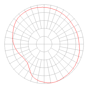 | ||||||||||||||||||
| Azimuth | Ratio | Azimuth | Ratio | Azimuth | Ratio | Azimuth | Ratio | ||||||||||||
| 0 | 0.926 | 10 | 0.918 | 20 | 0.907 | 30 | 0.897 | ||||||||||||
| 40 | 0.886 | 50 | 0.876 | 55 | 0.871 | 60 | 0.871 | ||||||||||||
| 70 | 0.875 | 80 | 0.879 | 90 | 0.886 | 100 | 0.910 | ||||||||||||
| 110 | 0.928 | 120 | 0.946 | 130 | 0.960 | 140 | 0.970 | ||||||||||||
| 150 | 0.981 | 160 | 0.999 | 165 | 1.000 | 170 | 0.995 | ||||||||||||
| 180 | 0.966 | 190 | 0.928 | 200 | 0.861 | 210 | 0.734 | ||||||||||||
| 220 | 0.645 | 230 | 0.624 | 240 | 0.637 | 250 | 0.680 | ||||||||||||
| 260 | 0.724 | 270 | 0.767 | 280 | 0.806 | 290 | 0.836 | ||||||||||||
| 300 | 0.876 | 310 | 0.913 | 320 | 0.934 | 330 | 0.941 | ||||||||||||
| 340 | 0.941 | 350 | 0.934 | ||||||||||||||||
Structure Registration Number 1032915 Structure Type: TOWER Registered To: Forever Media of MD, LLC Structure Address: 1605 Level Rd Havre De Grace, MD County Name: Harford County ASR Issued: 08/31/2023 Date Built: 01/01/1948 Site Elevation: 86 m (282 ft.) Structure Height: 77.4 m (254 ft.) Height Overall: 78.3 m (257 ft.) Overall Height AMSL: 164.3 m (539 ft.) FAA Determination: 01/09/1985 FAA Study #: 84-AEA-2138-OE FAA Circular #: 70/7460-1F Paint & Light FAA Chapters: 3, 4, 5 RED LIGHTS ONLY 39-33-55.0 N 76-07-07.0 W (NAD 83) 39-33-54.6 N 76-07-08.2 W (Converted to NAD 27) |
274 Lakemont Park Blvd Altoona, PA 16602 Phone: 412-221-1629 Limited Liability Company | Date: 10/31/2003 Application Certifier DELMARVA BROADCASTING COMPANY 2727 Shipley Road Wilmington, DE 19803 Applicant ROBERT W. GUILL 8405-a Richmond Highway Alexandria, VA 22309-2425 TECHNICAL CONSULTANT BRAD C. DEUTSCH Hogan & Hartson L.l.p. | |||||||||||||||||
| |||||||||||||||||||