
FCCInfo.com
A Service of Cavell, Mertz & Associates, Inc.
(855) FCC-INFO
|
|
K290BO from 04/01/2009 K290BO from 10/01/2004 |
|
|
||||||||||||||||
|
|
K290BO Channel: 290D 105.9 MHz The Dominion, Texas Service: FX - A translator or application for a translator. Facility ID: 139129 Fac. Service: FX Programming Delivery Method: Unspecified Status: License Application Accepted: 07/02/2014 Application Granted: 08/05/2014 File Number: BLFT-20140702ACS License Expires: 00/00/0000 Prefix Type: This is a license for a translator Application Type: License To Cover FCC Website Links: LMS Facility Details This Application CDBS Application Other K290BO Applications Other K290BO Applications in CDBS Including Superseded Applications Mailing Address Correspondence for K290BO Correspondence related to application BLFT-20140702ACS Service Contour - Open Street Map or USGS Map (60 dBu) Service Contour - KML / Google Earth (60 dBu) Class: D, A Noncommercial educational operating with no more than 10W Site Location: 29-38-01.8 N 98-37-55.1 W (NAD 83) Site Location: 29-38-01.0 N 98-37-54.0 W (Converted to NAD 27) Effective Radiated Power: 0.074 kW Transmitter Output Power: 0.068 kW Antenna Center HAAT: 0 m Antenna Center AMSL: 465 m (1526 ft.) Antenna Center HAG: 28 m (92 ft.) Site Elevation: 437 m. (1434 ft.) Height Overall*: 113 m (371 ft.) (* As Filed In This Application, may differ from ASR Data, Below.) Directional Antenna Antenna Make/Model: None Antenna ID: 117294 Polarization:
| ||||||||||||||||||
| Antenna Data for Antenna Id: 117294 K290BO FX File: BLFT-20140702ACS None - Service: FX | 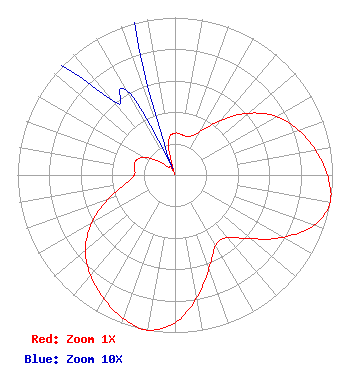 | ||||||||||||||||||
| Azimuth | Ratio | Azimuth | Ratio | Azimuth | Ratio | Azimuth | Ratio | ||||||||||||
| 0 | 0.265 | 10 | 0.259 | 20 | 0.259 | 30 | 0.316 | ||||||||||||
| 40 | 0.454 | 50 | 0.611 | 60 | 0.744 | 70 | 0.833 | ||||||||||||
| 80 | 0.906 | 90 | 0.967 | 100 | 1.000 | 110 | 0.938 | ||||||||||||
| 120 | 0.792 | 130 | 0.631 | 140 | 0.517 | 150 | 0.517 | ||||||||||||
| 160 | 0.631 | 170 | 0.792 | 180 | 0.938 | 190 | 1.000 | ||||||||||||
| 200 | 0.967 | 210 | 0.906 | 220 | 0.833 | 230 | 0.744 | ||||||||||||
| 240 | 0.611 | 250 | 0.454 | 260 | 0.316 | 270 | 0.259 | ||||||||||||
| 280 | 0.259 | 290 | 0.265 | 300 | 0.225 | 310 | 0.135 | ||||||||||||
| 320 | 0.062 | 330 | 0.062 | 340 | 0.013 | 350 | 0.225 | ||||||||||||
Structure Registration Number 1053919 Structure Type: GTOWER Registered To: American Towers LLC Structure Address: 7439 Heuerman Road (#207742) Leon Springs, TX County Name: Bexar County ASR Issued: 06/09/2021 Date Built: 09/15/1977 Site Elevation: 437.1 m (1434 ft.) Structure Height: 111.9 m (367 ft.) Height Overall: 112.8 m (370 ft.) Overall Height AMSL: 549.9 m (1804 ft.) FAA Determination: 06/07/2021 FAA Study #: 2021-ASW-7651-OE FAA Circular #: 70/7460-1M Paint & Light FAA Chapters: 4, 6, 15 PRIOR STUDY 2006-ASW-4904-OE 29-38-01.9 N 98-37-54.7 W (NAD 83) 29-38-01.1 N 98-37-53.6 W (Converted to NAD 27) |
8023 Vantage Drive San Antonio, TX 78230-4771 Phone: 210-340-7080 | Date: 07/02/2014 Application Certifier SAN ANTONIO RADIOWORKS, LLC 8023 Vantage Drive San Antonio, TX 78230-4771 Applicant JEREMY D. RUCK, PE Jeremy Ruck & Associates, Inc. P.o. Box 415 Canton, IL 61520 CONSULTING ENGINEER HARRY C. MARTIN Fletcher, Heald & Hildreth, P.l.c. 1300 N. 17th Street 11th Floor Arlington, VA 22209 | |||||||||||||||||