
FCCInfo.com
A Service of Cavell, Mertz & Associates, Inc.
(855) FCC-INFO
|
|
KISQ-FM2 from 06/01/1989 |
|
|
||||||||||||||||
|
|
KISQ-FM2 Channel: 251D 98.1 MHz Pleasanton, California Service: FB - A booster station or application for a booster. Facility ID: 59993 Fac. Service: FB Programming Delivery Method: Unspecified Status: License Application Accepted: 04/01/2011 Application Granted: 04/22/2011 File Number: BLFTB-20110401ABM License Expires: 00/00/0000 Prefix Type: This is a license for a booster Application Type: License To Cover FCC Website Links: LMS Facility Details This Application CDBS Application Other KISQ-FM2 Applications Other KISQ-FM2 Applications in CDBS Including Superseded Applications Mailing Address Correspondence for KISQ-FM2 Correspondence related to application BLFTB-20110401ABM Service Contour - Open Street Map or USGS Map (60 dBu) Service Contour - KML / Google Earth (60 dBu) Facility Type: FM STATION Class: D, A Noncommercial educational operating with no more than 10W Site Location: 37-39-39.8 N 121-50-15.8 W (NAD 83) Site Location: 37-39-40.0 N 121-50-12.0 W (Converted to NAD 27) Effective Radiated Power: 0 kW Horiz. ; 10 kW Vert. Transmitter Output Power: 1.2 kW Antenna Center HAAT: 0 m Antenna Center AMSL: 0 m Horiz.; 177 m Vert. Antenna Center HAG: 0 m Horiz.; 21 m Vert. Site Elevation: 156 m. (512 ft.) Height Overall*: 23 m (75 ft.) (* As Filed In This Application, may differ from ASR Data, Below.) Directional Antenna Antenna Make/Model: None Antenna ID: 16109 Polarization:
| ||||||||||||||||||
| Antenna Data for Antenna Id: 16109 KISQ-FM2 FB File: BLFTB-20110401ABM None - Service: FB Pattern and Field Values Include a 295° Clockwise Rotation | 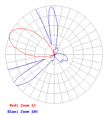 | ||||||||||||||||||
| Azimuth | Ratio | Azimuth | Ratio | Azimuth | Ratio | Azimuth | Ratio | ||||||||||||
| 5 | 0.067 | 15 | 0.014 | 25 | 0.015 | 35 | 0.014 | ||||||||||||
| 45 | 0.012 | 55 | 0.007 | 65 | 0.001 | 75 | 0.006 | ||||||||||||
| 85 | 0.015 | 95 | 0.023 | 105 | 0.028 | 115 | 0.030 | ||||||||||||
| 125 | 0.020 | 135 | 0.023 | 145 | 0.015 | 155 | 0.006 | ||||||||||||
| 165 | 0.001 | 175 | 0.007 | 185 | 0.012 | 195 | 0.014 | ||||||||||||
| 205 | 0.015 | 215 | 0.034 | 225 | 0.083 | 235 | 0.100 | ||||||||||||
| 245 | 0.023 | 255 | 0.150 | 265 | 0.406 | 275 | 0.690 | ||||||||||||
| 285 | 0.915 | 295 | 1.000 | 305 | 0.915 | 315 | 0.688 | ||||||||||||
| 325 | 0.404 | 335 | 0.148 | 345 | 0.022 | 355 | 0.095 | ||||||||||||
Structure Registration Number 1239226 Structure Type: POLE Registered To: Vertical Bridge CC FM, LLC Structure Address: 2500 Vineyard Avenue Pleasanton, CA County Name: Alameda County ASR Issued: 12/19/2018 Date Built: 06/19/2003 Site Elevation: 155.7 m (511 ft.) Structure Height: 22.9 m (75 ft.) Height Overall: 22.9 m (75 ft.) Overall Height AMSL: 178.6 m (586 ft.) FAA Determination: 10/16/2002 FAA Study #: 2002-AWP-3001-OE Paint & Light FAA Chapters: NONE PRIOR STUDY 2002-AWP-2505-OE 37-39-39.8 N 121-50-15.8 W (NAD 83) 37-39-40.0 N 121-50-12.0 W (Converted to NAD 27) |
7136 S. Yale Avenue Suite 501 Tulsa, OK 74136 Phone: 918-664-4581 | Date: 04/01/2011 Application Certifier AMFM BROADCASTING LICENSES, LLC 2625 S. Memorial Dr. Suite A Tulsa, OK 74129 Applicant TROY G. LANGHAM 2625 S. Memorial Dr. Suite A Tulsa, OK 74129 FCC ENGINEERING SUPVERVISOR TROY LANGHAM Clear Channel 2625 S. Memorial Dr. Suite A Tulsa, OK 74129 | |||||||||||||||||