
FCCInfo.com
A Service of Cavell, Mertz & Associates, Inc.
(855) FCC-INFO
|
|
K254CR from 10/24/2013 |
|
|
||||||||||||||||
|
|
K254CR Channel: 254D 98.7 MHz St. Louis, Missouri Service: FX - A translator or application for a translator. Facility ID: 138424 Fac. Service: FX Programming Delivery Method: Unspecified Status: License Application Accepted: 09/14/2016 Application Granted: 09/26/2016 File Number: BLFT-20160914AAX License Expires: 00/00/0000 Prefix Type: This is a license for a translator Application Type: License To Cover FCC Website Links: LMS Facility Details This Application CDBS Application Other K254CR Applications Other K254CR Applications in CDBS Including Superseded Applications Mailing Address Correspondence for K254CR Correspondence related to application BLFT-20160914AAX Service Contour - Open Street Map or USGS Map (60 dBu) Service Contour - KML / Google Earth (60 dBu) Class: D, A Noncommercial educational operating with no more than 10W Site Location: 38-36-47.2 N 90-20-09.4 W (NAD 83) Site Location: 38-36-47.0 N 90-20-09.0 W (Converted to NAD 27) Effective Radiated Power: 0.25 kW Transmitter Output Power: 0.863 kW Antenna Center HAAT: 0 m Antenna Center AMSL: 303 m (994 ft.) Antenna Center HAG: 162 m (531 ft.) Site Elevation: 141 m. (463 ft.) Height Overall*: 192 m (630 ft.) (* As Filed In This Application, may differ from ASR Data, Below.) Directional Antenna Antenna Make/Model: None Antenna ID: 124923 Polarization:
| ||||||||||||||||||
| Antenna Data for Antenna Id: 124923 K254CR FX File: BLFT-20160914AAX None - Service: FX Pattern and Field Values Include a 150° Clockwise Rotation | 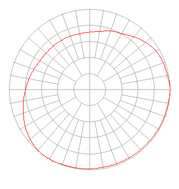 | ||||||||||||||||||
| Azimuth | Ratio | Azimuth | Ratio | Azimuth | Ratio | Azimuth | Ratio | ||||||||||||
| 0 | 0.712 | 10 | 0.732 | 20 | 0.772 | 30 | 0.802 | ||||||||||||
| 40 | 0.853 | 50 | 0.909 | 60 | 0.953 | 70 | 0.973 | ||||||||||||
| 80 | 0.983 | 90 | 1.000 | 100 | 0.992 | 110 | 0.988 | ||||||||||||
| 120 | 0.988 | 130 | 0.983 | 140 | 0.983 | 150 | 0.983 | ||||||||||||
| 160 | 0.983 | 170 | 0.983 | 180 | 0.988 | 190 | 0.988 | ||||||||||||
| 200 | 0.992 | 210 | 1.000 | 220 | 0.991 | 230 | 0.963 | ||||||||||||
| 240 | 0.923 | 250 | 0.873 | 260 | 0.832 | 270 | 0.792 | ||||||||||||
| 280 | 0.762 | 290 | 0.732 | 300 | 0.710 | 310 | 0.702 | ||||||||||||
| 320 | 0.702 | 330 | 0.702 | 340 | 0.702 | 350 | 0.702 | ||||||||||||
Structure Registration Number 1007729 Structure Type: TOWER Registered To: COMMUNICATIONS FUND INC Structure Address: 2628 Porter Ave Brentwood, MO County Name: St. Louis County ASR Issued: 01/28/1997 Date Built: 11/15/1981 Site Elevation: 141 m (463 ft.) Structure Height: 191.4 m (628 ft.) Height Overall: 192.3 m (631 ft.) Overall Height AMSL: 333.3 m (1094 ft.) Paint & Light FAA Chapters: 1, 3, 5, 14, 21 38-36-47.0 N 90-20-09.0 W (NAD 83) 38-36-46.8 N 90-20-08.6 W (Converted to NAD 27) |
2400 Market Street 4th Floor Philadelphia, PA 19103 Phone: 610-660-5610 Limited Liability Company | Date: 09/14/2016 Application Certifier EMMIS RADIO LICENSE, LLC One Emmis Plaza 40 Monument Circle, Suite 700 Indianapolis, IN 46204 Applicant DONALD LYNCH 111 Sam Houston Drive Kerrville, TX 78028 TECHNICAL CONSULTANT GREGORY L. MASTERS Wiley Rein Llp 1776 K Street, N.w. Washington, DC 20006 | |||||||||||||||||