
FCCInfo.com
A Service of Cavell, Mertz & Associates, Inc.
(855) FCC-INFO
|
|
KPWR from 10/15/1982 |
|  |
|
|||||||||||||||
|
|
KPWR Channel: 290B 105.9 MHz Los Angeles, California Service: FM - A full-service FM station or application. Facility ID: 35498 Fac. Service: FM Analog & Digital Status: License Application Accepted: 12/21/2010 Application Granted: 01/13/2011 File Number: BMLH-20101221ACA License Expires: 00/00/0000 Prefix Type: This is a modification of a license for a commecial FM station Application Type: Minor Amendment FCC Website Links: LMS Facility Details This Application CDBS Application Other KPWR Applications Other KPWR Applications in CDBS Including Superseded Applications Mailing Address Correspondence for KPWR Correspondence related to application BMLH-20101221ACA Service Contour - Open Street Map or USGS Map (54 dBu) Service Contour - KML / Google Earth (54 dBu) Public Inspection Files History Cards for KPWR Facility Type: FM STATION Class: B, A Zone I or I-A station; with 25kW-50kW ERP and a class contour distance 39km-52km Site Location: 34-13-38.0 N 118-04-03.2 W (NAD 83) Site Location: 34-13-38.0 N 118-03-60.0 W (Converted to NAD 27) Effective Radiated Power: 25 kW Transmitter Output Power: 17.3 kW Antenna Center HAAT: 925 m (3035 ft.) Antenna Center AMSL: 1811 m (5942 ft.) Antenna Center HAG: 70 m (230 ft.) Calculated Site Elevation: 1741 m. (5712 ft.) Height Overall*: 141 m (463 ft.) (* As Filed In This Application, may differ from ASR Data, Below.) Directional Antenna Antenna Make/Model: Electronics Research Inc. 1182-1CP-DA Antenna ID: 13561 Polarization:
| ||||||||||||||||||
| Antenna Data for Antenna Id: 13561 KPWR FM File: BMLH-20101221ACA Electronics Research Inc. - 1182-1CP-DA Service: FM | 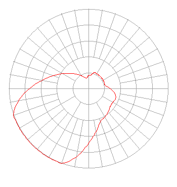 | ||||||||||||||||||
| Azimuth | Ratio | Azimuth | Ratio | Azimuth | Ratio | Azimuth | Ratio | ||||||||||||
| 0 | 0.162 | 10 | 0.170 | 20 | 0.211 | 30 | 0.211 | ||||||||||||
| 40 | 0.211 | 50 | 0.211 | 60 | 0.211 | 70 | 0.211 | ||||||||||||
| 80 | 0.214 | 90 | 0.269 | 100 | 0.335 | 110 | 0.363 | ||||||||||||
| 120 | 0.351 | 130 | 0.355 | 140 | 0.385 | 150 | 0.412 | ||||||||||||
| 160 | 0.442 | 170 | 0.550 | 180 | 0.692 | 190 | 0.871 | ||||||||||||
| 200 | 1.000 | 210 | 1.000 | 220 | 1.000 | 230 | 1.000 | ||||||||||||
| 240 | 1.000 | 250 | 1.000 | 260 | 0.891 | 270 | 0.741 | ||||||||||||
| 280 | 0.589 | 290 | 0.468 | 300 | 0.372 | 310 | 0.295 | ||||||||||||
| 320 | 0.234 | 330 | 0.186 | 340 | 0.148 | 350 | 0.132 | ||||||||||||
Structure Registration Number 1007719 Structure Type: LTOWER Registered To: American Towers LLC Structure Address: Mount Wilson Altadena, CA County Name: Los Angeles County ASR Issued: 05/22/2017 Date Built: 01/01/1983 Site Elevation: 1741 m (5712 ft.) Structure Height: 118 m (387 ft.) Height Overall: 141.4 m (464 ft.) Overall Height AMSL: 1882.4 m (6176 ft.) FAA Determination: 01/01/1983 FAA Study #: 83-AWP-779-OE Paint & Light FAA Chapters: NONE 34-13-38.0 N 118-04-03.0 W (NAD 83) 34-13-38.0 N 118-03-59.8 W (Converted to NAD 27) |
9550 Firestone Blvd. Downey, CA 90241 Phone: 562-745-2312 Limited Liability Company | Date: 12/21/2010 Application Certifier EMMIS RADIO LICENSE, LLC One Emmis Plaza 40 Monument Circle, Suite 700 Indianapolis, IN 46204 Applicant KEVIN T. FISHER 2237 Tacketts Mill Drive Suite A Lake Ridge, VA 22192 ENGINEERING CONSULTANT JOHN E. FIORINI, III Wiley Rein Llp | |||||||||||||||||
|
| ||||||||||||||||||