
FCCInfo.com
A Service of Cavell, Mertz & Associates, Inc.
(855) FCC-INFO
|
|
KYFQ from 03/11/2004 KYFQ from 10/12/1992 KYFQ from 05/31/1986 |
|  |
|
|||||||||||||||
|
|
KYFQ Channel: 219C1 91.7 MHz Tacoma, Washington Service: FM - A full-service FM station or application. Facility ID: 62470 Fac. Service: FM Status: License Application Accepted: 02/22/2013 Application Granted: 03/12/2013 File Number: BLED-20130222ACV License Expires: 00/00/0000 Prefix Type: This is a license for a noncommercial educational FM station Application Type: License To Cover FCC Website Links: LMS Facility Details This Application CDBS Application Other KYFQ Applications Other KYFQ Applications in CDBS Including Superseded Applications Mailing Address Correspondence for KYFQ Correspondence related to application BLED-20130222ACV Service Contour - Open Street Map or USGS Map (60 dBu) Service Contour - KML / Google Earth (60 dBu) Public Inspection Files History Cards for KYFQ Facility Type: NON-COMMERCIAL EDUC. FM Class: C1, A Zone II station; with 50kW-100kW ERP and a class contour distance 52km-72km Site Location: 47-32-52.3 N 122-48-26.5 W (NAD 83) Site Location: 47-32-53.0 N 122-48-22.0 W (Converted to NAD 27) Effective Radiated Power: 4.3 kW Transmitter Output Power: 5.6 kW Antenna Center HAAT: 582 m (1909 ft.) Antenna Center AMSL: 689 m (2260 ft.) Antenna Center HAG: 175 m (574 ft.) Calculated Site Elevation: 514 m. (1686 ft.) Height Overall*: 215 m (705 ft.) (* As Filed In This Application, may differ from ASR Data, Below.) Directional Antenna Antenna Make/Model: Electronics Research Inc. 1192-1CP-DA Antenna ID: 13376 Polarization: | ||||||||||||||||||
| Antenna Data for Antenna Id: 13376 KYFQ FM File: BLED-20130222ACV Electronics Research Inc. - 1192-1CP-DA Service: FM | 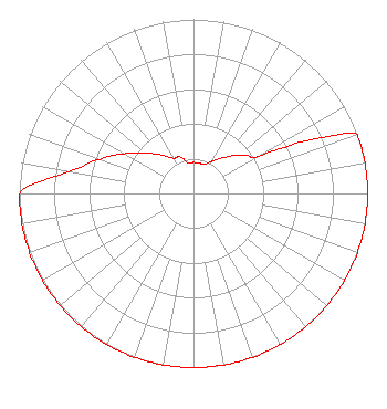 | ||||||||||||||||||
| Azimuth | Ratio | Azimuth | Ratio | Azimuth | Ratio | Azimuth | Ratio | ||||||||||||
| 0 | 0.178 | 10 | 0.178 | 20 | 0.178 | 30 | 0.214 | ||||||||||||
| 40 | 0.268 | 50 | 0.339 | 55 | 0.378 | 60 | 0.427 | ||||||||||||
| 65 | 0.711 | 70 | 1.000 | 80 | 1.000 | 90 | 1.000 | ||||||||||||
| 100 | 1.000 | 110 | 1.000 | 120 | 1.000 | 130 | 1.000 | ||||||||||||
| 140 | 1.000 | 150 | 1.000 | 160 | 1.000 | 170 | 1.000 | ||||||||||||
| 180 | 1.000 | 190 | 1.000 | 200 | 1.000 | 210 | 1.000 | ||||||||||||
| 220 | 1.000 | 230 | 1.000 | 240 | 1.000 | 250 | 1.000 | ||||||||||||
| 260 | 1.000 | 270 | 1.000 | 280 | 0.725 | 290 | 0.575 | ||||||||||||
| 300 | 0.457 | 310 | 0.363 | 320 | 0.288 | 330 | 0.234 | ||||||||||||
| 340 | 0.224 | 350 | 0.178 | ||||||||||||||||
Structure Registration Number 1049708 Structure Type: GTOWER Registered To: Fox Television Stations, LLC Structure Address: Gold Mountain 6.5 Mi W Bremerton, WA County Name: Kitsap County ASR Issued: 11/05/2020 Date Built: 01/01/1992 Site Elevation: 514.2 m (1687 ft.) Structure Height: 195 m (640 ft.) Height Overall: 214.6 m (704 ft.) Overall Height AMSL: 728.8 m (2391 ft.) FAA Determination: 12/09/1992 FAA Study #: 92-ANM-0814-OE Paint & Light FAA Chapters: A1, B, D, H, 3, 6, 15, 21, 23 DUAL HIGH INTENSITY WHITE LIGHTS 47-32-52.0 N 122-48-27.0 W (NAD 83) 47-32-52.7 N 122-48-22.5 W (Converted to NAD 27) |
11530 Carmel Commons Blvd. Charlotte, NC 28226 Phone: 704-523-5555 Not-for-Profit | Date: 02/22/2013 Application Certifier PRC TACOMA -- I LLC 5277 Manhattan Circle #210 Boulder, CO 80303 Applicant BERTRAM S. GOLDMAN 7219 Highland Heather La. Dallas, TX 75248 TECHNICAL CONSULTANT JOHN CRIGLER, ESQ. Garvey Schubert Barer | |||||||||||||||||
| |||||||||||||||||||