
FCCInfo.com
A Service of Cavell, Mertz & Associates, Inc.
(855) FCC-INFO
|
|
K299BR from 05/15/2013 |
|
|
||||||||||||||||
|
|
K299BR Channel: 299D 107.7 MHz Sonora, California Service: FX - A translator or application for a translator. Facility ID: 142351 Fac. Service: FX Programming Delivery Method: Unspecified Status: License Application Accepted: 04/05/2016 Application Granted: 04/18/2016 File Number: BLFT-20160405AAU License Expires: 00/00/0000 Prefix Type: This is a license for a translator Application Type: License To Cover FCC Website Links: LMS Facility Details This Application CDBS Application Other K299BR Applications Other K299BR Applications in CDBS Including Superseded Applications Mailing Address Correspondence for K299BR Correspondence related to application BLFT-20160405AAU Service Contour - Open Street Map or USGS Map (60 dBu) Service Contour - KML / Google Earth (60 dBu) Class: D, A Noncommercial educational operating with no more than 10W Site Location: 38-01-01.1 N 120-13-55.1 W (NAD 83) Site Location: 38-01-01.4 N 120-13-51.4 W (Converted to NAD 27) Effective Radiated Power: 0.132 kW Transmitter Output Power: 0.038 kW Antenna Center HAAT: 0 m Antenna Center AMSL: 1178 m (3865 ft.) Antenna Center HAG: 15 m (49 ft.) Site Elevation: 1163 m. (3816 ft.) Height Overall*: 40 m (131 ft.) (* As Filed In This Application, may differ from ASR Data, Below.) Directional Antenna Antenna Make/Model: None Antenna ID: 122933 Polarization:
| ||||||||||||||||||
| Antenna Data for Antenna Id: 122933 K299BR FX File: BLFT-20160405AAU None - Service: FX Pattern and Field Values Include a 245° Clockwise Rotation | 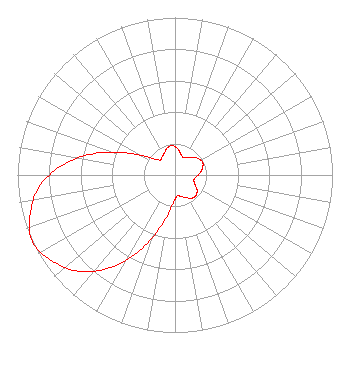 | ||||||||||||||||||
| Azimuth | Ratio | Azimuth | Ratio | Azimuth | Ratio | Azimuth | Ratio | ||||||||||||
| 5 | 0.171 | 15 | 0.140 | 25 | 0.123 | 35 | 0.135 | ||||||||||||
| 45 | 0.160 | 55 | 0.182 | 65 | 0.193 | 75 | 0.182 | ||||||||||||
| 85 | 0.160 | 95 | 0.135 | 105 | 0.123 | 115 | 0.140 | ||||||||||||
| 125 | 0.171 | 135 | 0.187 | 145 | 0.181 | 155 | 0.157 | ||||||||||||
| 165 | 0.142 | 175 | 0.134 | 185 | 0.190 | 195 | 0.329 | ||||||||||||
| 205 | 0.528 | 215 | 0.718 | 225 | 0.866 | 235 | 0.952 | ||||||||||||
| 245 | 1.000 | 255 | 0.952 | 265 | 0.866 | 275 | 0.718 | ||||||||||||
| 285 | 0.528 | 295 | 0.329 | 305 | 0.190 | 315 | 0.134 | ||||||||||||
| 325 | 0.142 | 335 | 0.157 | 345 | 0.181 | 355 | 0.187 | ||||||||||||
Structure Registration Number 1286635 Structure Type: LTOWER Registered To: American Towers LLC Structure Address: 21749 Knox Drive Twain Harte, CA County Name: Tuolumne County ASR Issued: 01/05/2021 Date Built: 01/01/1998 Site Elevation: 1163.4 m (3817 ft.) Structure Height: 39.6 m (130 ft.) Height Overall: 39.6 m (130 ft.) Overall Height AMSL: 1203 m (3947 ft.) FAA Determination: 08/30/2012 FAA Study #: 2012-AWP-6354-OE Paint & Light FAA Chapters: NONE 38-01-01.1 N 120-13-55.1 W (NAD 83) 38-01-01.4 N 120-13-51.4 W (Converted to NAD 27) |
10550 Barkley Suite 108 Overland Park, KS 66212 Phone: 913-642-7770 | Date: 04/05/2016 Application Certifier BOTT COMMUNICATIONS, INC. 10550 Barkley Suite 108 Overland Park, KS 66212 Applicant KATHLEEN VICTORY, ESQUIRE Fletcher, Heald & Hildreth, Plc 1300 North 17th Street 11th Floor Arlington, VA 22209 JEREMY D. RUCK, PE Jeremy Ruck & Associates, Inc. P.o. Box 415 Canton, IL 61520 CONSULTING ENGINEER | |||||||||||||||||