
FCCInfo.com
A Service of Cavell, Mertz & Associates, Inc.
(855) FCC-INFO
|
|
|
|
|
||||||||||||||||
|
|
K253BV Channel: 253D 98.5 MHz Oklahoma City, Oklahoma Service: FX - A translator or application for a translator. Facility ID: 140403 Fac. Service: FX Programming Delivery Method: Unspecified Status: License Application Accepted: 08/27/2015 Application Granted: 09/18/2015 File Number: BLFT-20150827AAF License Expires: 00/00/0000 Prefix Type: This is a license for a translator Application Type: License To Cover FCC Website Links: LMS Facility Details This Application CDBS Application Other K253BV Applications Other K253BV Applications in CDBS Including Superseded Applications Mailing Address Correspondence for K253BV Correspondence related to application BLFT-20150827AAF Service Contour - Open Street Map or USGS Map (60 dBu) Service Contour - KML / Google Earth (60 dBu) Class: D, A Noncommercial educational operating with no more than 10W Site Location: 35-34-24.2 N 97-29-09.1 W (NAD 83) Site Location: 35-34-24.0 N 97-29-08.0 W (Converted to NAD 27) Effective Radiated Power: 0.13 kW Transmitter Output Power: 0.531 kW Antenna Center HAAT: 0 m Antenna Center AMSL: 540 m (1772 ft.) Antenna Center HAG: 180 m (591 ft.) Site Elevation: 360 m. (1181 ft.) Height Overall*: 260 m (853 ft.) (* As Filed In This Application, may differ from ASR Data, Below.) Directional Antenna Antenna Make/Model: None Antenna ID: 120717 Polarization:
| ||||||||||||||||||
| Antenna Data for Antenna Id: 120717 K253BV FX File: BLFT-20150827AAF None - Service: FX | 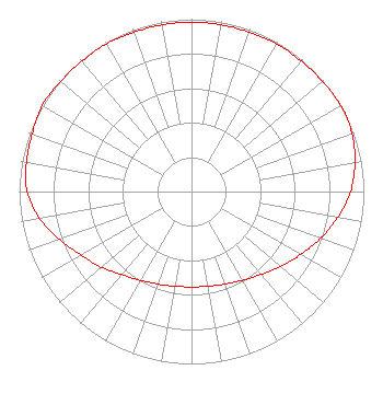 | ||||||||||||||||||
| Azimuth | Ratio | Azimuth | Ratio | Azimuth | Ratio | Azimuth | Ratio | ||||||||||||
| 0 | 0.983 | 10 | 0.983 | 20 | 0.983 | 30 | 0.988 | ||||||||||||
| 40 | 0.988 | 50 | 0.992 | 60 | 1.000 | 70 | 0.991 | ||||||||||||
| 80 | 0.963 | 90 | 0.923 | 100 | 0.862 | 110 | 0.797 | ||||||||||||
| 120 | 0.731 | 130 | 0.676 | 140 | 0.628 | 150 | 0.594 | ||||||||||||
| 160 | 0.571 | 170 | 0.558 | 180 | 0.553 | 190 | 0.558 | ||||||||||||
| 200 | 0.571 | 210 | 0.594 | 220 | 0.628 | 230 | 0.682 | ||||||||||||
| 240 | 0.738 | 250 | 0.815 | 260 | 0.897 | 270 | 0.953 | ||||||||||||
| 280 | 0.973 | 290 | 0.983 | 300 | 1.000 | 310 | 0.992 | ||||||||||||
| 320 | 0.988 | 330 | 0.988 | 340 | 0.983 | 350 | 0.983 | ||||||||||||
Structure Registration Number 1012601 Structure Type: Registered To: UNIVERSITY OF CENTRAL OKLAHOMA Structure Address: 1501 Ne 101 St Oklahoma City, OK County Name: Oklahoma County ASR Issued: 06/08/2023 Date Built: 04/04/1997 Site Elevation: 359.7 m (1180 ft.) Structure Height: 259.1 m (850 ft.) Height Overall: 260 m (853 ft.) Overall Height AMSL: 619.7 m (2033 ft.) FAA Determination: 10/14/1997 FAA Study #: 97-ASW-2228-OE FAA Circular #: 70/7460-1J Paint & Light FAA Chapters: 3, 4, 5, 13 Removed expiration and final dates from determination. Scenario 2./jjs/case#635066 35-34-24.4 N 97-29-09.5 W (NAD 83) 35-34-24.2 N 97-29-08.4 W (Converted to NAD 27) |
7136 S. Yale Avenue Suite 501 Tulsa, OK 74136 Phone: 918-664-4581 | Date: 08/27/2015 Application Certifier EDUCATIONAL MEDIA FOUNDATION 5700 West Oaks Blvd Rocklin, CA 95765 Applicant STEPHEN WILDE 5700 West Oaks Blvd Rocklin, CA 95765 BROADCAST ENGINEER MARY N. O'CONNOR Educational Media Foundation 2300 N. Street, N.w. Washington, DC 20037-1128 | |||||||||||||||||