
FCCInfo.com
A Service of Cavell, Mertz & Associates, Inc.
(855) FCC-INFO
|
|
K231CT from 07/19/2004 |
|
|
||||||||||||||||
|
|
K231CT Channel: 231D 94.1 MHz Walla Walla, Washington Service: FX - A translator or application for a translator. Facility ID: 149014 Fac. Service: FX Programming Delivery Method: Unspecified Status: License Application Accepted: 08/02/2016 Application Granted: 08/22/2016 File Number: BLFT-20160802AAT License Expires: 00/00/0000 Prefix Type: This is a license for a translator Application Type: License To Cover FCC Website Links: LMS Facility Details This Application CDBS Application Other K231CT Applications Other K231CT Applications in CDBS Including Superseded Applications Mailing Address Correspondence for K231CT Correspondence related to application BLFT-20160802AAT Service Contour - Open Street Map or USGS Map (60 dBu) Service Contour - KML / Google Earth (60 dBu) Class: D, A Noncommercial educational operating with no more than 10W Site Location: 46-01-24.0 N 118-21-21.0 W (NAD 83) Site Location: 46-01-24.5 N 118-21-17.1 W (Converted to NAD 27) Effective Radiated Power: 0.155 kW Transmitter Output Power: 0.35 kW Antenna Center HAAT: 0 m Antenna Center AMSL: 313 m (1027 ft.) Antenna Center HAG: 55 m (180 ft.) Site Elevation: 258 m. (846 ft.) Height Overall*: 61 m (200 ft.) (* As Filed In This Application, may differ from ASR Data, Below.) Directional Antenna Antenna Make/Model: None Antenna ID: 124811 Polarization:
| ||||||||||||||||||
| Antenna Data for Antenna Id: 124811 K231CT FX File: BLFT-20160802AAT None - Service: FX Pattern and Field Values Include a 270° Clockwise Rotation | 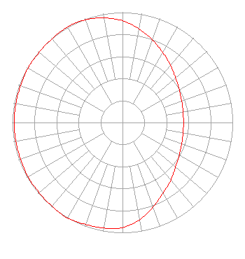 | ||||||||||||||||||
| Azimuth | Ratio | Azimuth | Ratio | Azimuth | Ratio | Azimuth | Ratio | ||||||||||||
| 0 | 0.923 | 10 | 0.862 | 20 | 0.797 | 30 | 0.731 | ||||||||||||
| 40 | 0.676 | 50 | 0.628 | 60 | 0.594 | 70 | 0.571 | ||||||||||||
| 80 | 0.558 | 90 | 0.553 | 100 | 0.558 | 110 | 0.571 | ||||||||||||
| 120 | 0.594 | 130 | 0.628 | 140 | 0.682 | 150 | 0.738 | ||||||||||||
| 160 | 0.815 | 170 | 0.897 | 180 | 0.953 | 190 | 0.973 | ||||||||||||
| 200 | 0.983 | 210 | 1.000 | 220 | 0.992 | 230 | 0.988 | ||||||||||||
| 240 | 0.988 | 250 | 0.983 | 260 | 0.983 | 270 | 0.983 | ||||||||||||
| 280 | 0.983 | 290 | 0.983 | 300 | 0.988 | 310 | 0.988 | ||||||||||||
| 320 | 0.992 | 330 | 1.000 | 340 | 0.991 | 350 | 0.963 | ||||||||||||
Structure Registration Number 1032815 Structure Type: TOWER Registered To: Two Hearts Communications, LLC Structure Address: .75 Km W Of Braden Rd & Old Milton-freewater Hwy Walla Walla, WA County Name: Walla Walla County ASR Issued: 10/14/2005 Date Built: 08/15/1989 Site Elevation: 257.6 m (845 ft.) Structure Height: 60.6 m (199 ft.) Height Overall: 60.6 m (199 ft.) Overall Height AMSL: 318.2 m (1044 ft.) FAA Determination: 09/28/1989 FAA Study #: 89-ANM-0552-OE FAA Circular #: 70/7460-1G Paint & Light FAA Chapters: 3, 4, 5, 9 46-01-24.0 N 118-21-21.0 W (NAD 83) 46-01-24.5 N 118-21-17.1 W (Converted to NAD 27) |
1230 Colonial Drive College Place, WA 99324 Phone: 509-394-3261 | Date: 08/02/2016 Application Certifier TWO HEARTS COMMUNICATIONS, LLC 1230 Colonial Drive College Place, WA 99324 Applicant ERIK C. SWANSON, P.E. Hatfield & Dawson Consulting Engineers, 9500 Greenwood Ave N Seattle, WA 98103 CONSULTING ENGINEER TWO HEARTS COMMUNICATIONS, LLC Two Hearts Communications, Llc 1230 Colonial Drive College Place, WA 99324 | |||||||||||||||||