
FCCInfo.com
A Service of Cavell, Mertz & Associates, Inc.
(855) FCC-INFO
|
|
WLFS from 03/06/1998 |
|  |
|
|||||||||||||||
|
|
WLFS Channel: 220A 91.9 MHz Port Wentworth, Georgia Service: FS - A full service FM station auxiliary transmitting antenna or application. Facility ID: 85801 Fac. Service: FM Analog & Digital Status: License 73.215 Station Application Accepted: 02/24/2009 Application Granted: 03/03/2009 File Number: BXMLED-20090224ABI License Expires: 00/00/0000 Prefix Type: This is BXMLED Application Type: Minor Modification FCC Website Links: LMS Facility Details This Application CDBS Application Other WLFS Applications Other WLFS Applications in CDBS Including Superseded Applications Mailing Address Correspondence for WLFS Correspondence related to application BXMLED-20090224ABI Service Contour - Open Street Map or USGS Map (60 dBu) Service Contour - KML / Google Earth (60 dBu) Public Inspection Files Facility Type: NON-COMMERCIAL EDUC. FM Class: A, A Zone I; I-A; or II station; with 0.1kW-6kW ERP and a class contour distance <=28km Site Location: 32-09-17.7 N 81-09-54.4 W (NAD 83) Site Location: 32-09-17.0 N 81-09-55.0 W (Converted to NAD 27) Effective Radiated Power: 0.4 kW Transmitter Output Power: 0.198 kW Antenna Center HAAT: 55 m (180 ft.) Antenna Center AMSL: 58 m (190 ft.) Antenna Center HAG: 52 m (171 ft.) Calculated Site Elevation: 6 m. (20 ft.) Height Overall*: 55 m (180 ft.) (* As Filed In This Application, may differ from ASR Data, Below.) Directional Antenna Antenna Make/Model: Shivley 6810-2-DA, two sections Antenna ID: 15116 Polarization:
| ||||||||||||||||||
| Antenna Data for Antenna Id: 15116 WLFS FS File: BXMLED-20090224ABI Shivley - 6810-2-DA, two sections Service: FS | 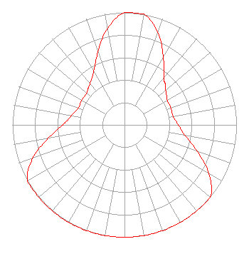 | ||||||||||||||||||
| Azimuth | Ratio | Azimuth | Ratio | Azimuth | Ratio | Azimuth | Ratio | ||||||||||||
| 0 | 1.000 | 10 | 1.000 | 20 | 0.872 | 30 | 0.692 | ||||||||||||
| 40 | 0.550 | 45 | 0.514 | 50 | 0.480 | 60 | 0.440 | ||||||||||||
| 70 | 0.440 | 80 | 0.440 | 90 | 0.480 | 100 | 0.550 | ||||||||||||
| 110 | 0.692 | 120 | 0.872 | 130 | 1.000 | 135 | 1.000 | ||||||||||||
| 140 | 1.000 | 150 | 1.000 | 160 | 1.000 | 170 | 1.000 | ||||||||||||
| 180 | 1.000 | 190 | 1.000 | 200 | 1.000 | 210 | 1.000 | ||||||||||||
| 220 | 1.000 | 225 | 1.000 | 230 | 1.000 | 240 | 1.000 | ||||||||||||
| 250 | 0.872 | 260 | 0.692 | 270 | 0.550 | 280 | 0.480 | ||||||||||||
| 290 | 0.440 | 300 | 0.440 | 310 | 0.440 | 315 | 0.460 | ||||||||||||
| 320 | 0.480 | 330 | 0.550 | 340 | 0.692 | 350 | 0.872 | ||||||||||||
Structure Registration Number 1018662 Structure Type: TOWER Registered To: RADIO TRAINING NETWORK INC Structure Address: From City Business District Us 17 N To Int Of Appleby Rd 50 Meters W Port Wentworth, GA County Name: Chatham County ASR Issued: 01/05/2004 Date Built: 01/20/2001 Site Elevation: 6.4 m (21 ft.) Structure Height: 54.9 m (180 ft.) Height Overall: 54.9 m (180 ft.) Overall Height AMSL: 61.3 m (201 ft.) FAA Determination: 07/28/1997 FAA Study #: 97-ASO-1989-OE Paint & Light FAA Chapters: NONE Removed expiration date from determination. Scenario 1./jjs/case#635066 32-09-18.0 N 81-09-54.0 W (NAD 83) 32-09-17.3 N 81-09-54.6 W (Converted to NAD 27) |
Po Box 7217 Lakeland, FL 33807-7217 Phone: 863-644-3464 Not-for-Profit | Date: 02/24/2009 Application Certifier RADIO TRAINING NETWORK, INC. P.o. Box 7217 Lakeland, FL 33807-7217 Applicant JEFFERSON G. BROCK Graham Brock, Inc. P.o. Box 24466 St. Simons Island, GA 31522-7466 TECHNICAL CONSULTANT A. WRAY FITCH III Gammon & Grange, P.c. | |||||||||||||||||