
FCCInfo.com
A Service of Cavell, Mertz & Associates, Inc.
(855) FCC-INFO
|
|
|
|  |
|
|||||||||||||||
|
|
WYFB Channel: 213C1 90.5 MHz Gainesville, Florida Service: FM - A full-service FM station or application. Facility ID: 5083 Fac. Service: FM Status: License Application Accepted: 10/18/2017 Application Granted: 11/17/2017 File Number: BLED-20171018AAU License Expires: 00/00/0000 Prefix Type: This is a license for a noncommercial educational FM station Application Type: License To Cover FCC Website Links: LMS Facility Details This Application CDBS Application Other WYFB Applications Other WYFB Applications in CDBS Including Superseded Applications Mailing Address Correspondence for WYFB Correspondence related to application BLED-20171018AAU Service Contour - Open Street Map or USGS Map (60 dBu) Service Contour - KML / Google Earth (60 dBu) Public Inspection Files Facility Type: NON-COMMERCIAL EDUC. FM Class: C1, A Zone II station; with 50kW-100kW ERP and a class contour distance 52km-72km Site Location: 29-52-12.9 N 82-12-06.4 W (NAD 83) Site Location: 29-52-12.0 N 82-12-07.0 W (Converted to NAD 27) Effective Radiated Power: 97 kW Transmitter Output Power: 25.5 kW Antenna Center HAAT: 202 m (663 ft.) Antenna Center AMSL: 246 m (807 ft.) Antenna Center HAG: 202 m (663 ft.) Calculated Site Elevation: 44 m. (144 ft.) Height Overall*: 214 m (702 ft.) (* As Filed In This Application, may differ from ASR Data, Below.) Directional Antenna Antenna Make/Model: Jampro JHPC-6(DA), six sections Antenna ID: 129262 Polarization:
| ||||||||||||||||||
| Antenna Data for Antenna Id: 129262 WYFB FM File: BLED-20171018AAU Jampro - JHPC-6(DA), six sections Service: FM | 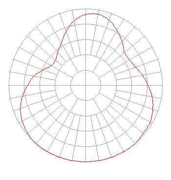 | ||||||||||||||||||
| Azimuth | Ratio | Azimuth | Ratio | Azimuth | Ratio | Azimuth | Ratio | ||||||||||||
| 0 | 0.920 | 10 | 0.940 | 20 | 0.900 | 30 | 0.820 | ||||||||||||
| 40 | 0.740 | 50 | 0.660 | 60 | 0.660 | 70 | 0.690 | ||||||||||||
| 80 | 0.750 | 90 | 0.810 | 100 | 0.880 | 110 | 0.930 | ||||||||||||
| 120 | 0.970 | 130 | 0.980 | 140 | 1.000 | 150 | 1.000 | ||||||||||||
| 160 | 1.000 | 170 | 1.000 | 180 | 1.000 | 190 | 1.000 | ||||||||||||
| 200 | 1.000 | 210 | 1.000 | 220 | 1.000 | 230 | 0.980 | ||||||||||||
| 240 | 0.950 | 250 | 0.900 | 260 | 0.830 | 270 | 0.750 | ||||||||||||
| 280 | 0.680 | 290 | 0.580 | 300 | 0.510 | 310 | 0.510 | ||||||||||||
| 320 | 0.560 | 330 | 0.630 | 340 | 0.740 | 350 | 0.850 | ||||||||||||
Structure Registration Number 1002310 Structure Type: GTOWER Registered To: Bible Broadcasting Network, Inc. Structure Address: 0.25 Km North Of The "t" Intersection Of Sw 105 Street And Sw County Road 18. Hampton, FL County Name: Bradford County ASR Issued: 08/25/2017 Date Built: 03/26/1999 Site Elevation: 43.6 m (143 ft.) Structure Height: 212.7 m (698 ft.) Height Overall: 213.6 m (701 ft.) Overall Height AMSL: 257.2 m (844 ft.) FAA Determination: 08/11/2017 FAA Study #: 2017-ASO-11376-OE FAA Circular #: 70/7460-1L Paint & Light FAA Chapters: 3, 4, 5, 12 Removed expiration date from determination. Scenario 1./jjs/case#635066 29-52-12.7 N 82-12-06.0 W (NAD 83) 29-52-11.8 N 82-12-06.6 W (Converted to NAD 27) |
11530 Carmel Commons Blvd Charlotte, NC 28226-3976 Phone: 704-523-5555 Not-for-Profit | Date: 10/18/2017 Application Certifier BIBLE BROADCASTING NETWORK, INC. 11530 Carmel Commons Blvd. Charlotte, NC 28226 Applicant JUSTIN ASHER Asher Broadcast Consulting, Llc 579 Babcock Road Bronson, MI 49028-9347 TECHNICAL CONSULTANT GARY S. SMITHWICK, ESQ. Smithwick & Belendiuk, P.c. | |||||||||||||||||