
FCCInfo.com
A Service of Cavell, Mertz & Associates, Inc.
(855) FCC-INFO
|
|
K245BD from 09/10/2004 |
|
|
||||||||||||||||
|
|
K245BD Channel: 245D 96.9 MHz Spearfish, South Dakota Service: FX - A translator or application for a translator. Facility ID: 142015 Fac. Service: FX Programming Delivery Method: Unspecified Status: License Application Accepted: 06/17/2011 Application Granted: 07/12/2011 File Number: BLFT-20110617ABO License Expires: 00/00/0000 Prefix Type: This is a license for a translator Application Type: License To Cover FCC Website Links: LMS Facility Details This Application CDBS Application Other K245BD Applications Other K245BD Applications in CDBS Including Superseded Applications Mailing Address Correspondence for K245BD Correspondence related to application BLFT-20110617ABO Service Contour - Open Street Map or USGS Map (60 dBu) Service Contour - KML / Google Earth (60 dBu) Class: D, A Noncommercial educational operating with no more than 10W Site Location: 44-29-32.9 N 103-50-06.7 W (NAD 83) Site Location: 44-29-33.0 N 103-50-05.0 W (Converted to NAD 27) Effective Radiated Power: 0.053 kW Transmitter Output Power: 0.033 kW Antenna Center HAAT: 132.2 m Horiz.; 0 m Vert. Antenna Center AMSL: 1374 m (4508 ft.) Antenna Center HAG: 9 m (30 ft.) Site Elevation: 1365 m. (4478 ft.) Height Overall*: 20 m (66 ft.) (* As Filed In This Application, may differ from ASR Data, Below.) Directional Antenna Antenna Make/Model: None Antenna ID: 16178 Polarization:
| ||||||||||||||||||
| Antenna Data for Antenna Id: 16178 K245BD FX File: BLFT-20110617ABO None - Service: FX Pattern and Field Values Include a 270° Clockwise Rotation | 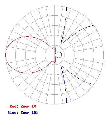 | ||||||||||||||||||
| Azimuth | Ratio | Azimuth | Ratio | Azimuth | Ratio | Azimuth | Ratio | ||||||||||||
| 0 | 0.157 | 10 | 0.130 | 20 | 0.060 | 30 | 0.027 | ||||||||||||
| 40 | 0.042 | 50 | 0.088 | 60 | 0.117 | 70 | 0.134 | ||||||||||||
| 80 | 0.143 | 90 | 0.145 | 100 | 0.143 | 110 | 0.134 | ||||||||||||
| 120 | 0.117 | 130 | 0.088 | 140 | 0.042 | 150 | 0.027 | ||||||||||||
| 160 | 0.060 | 170 | 0.130 | 180 | 0.157 | 190 | 0.141 | ||||||||||||
| 200 | 0.138 | 210 | 0.203 | 220 | 0.363 | 230 | 0.553 | ||||||||||||
| 240 | 0.727 | 250 | 0.871 | 260 | 0.966 | 270 | 1.000 | ||||||||||||
| 280 | 0.966 | 290 | 0.871 | 300 | 0.727 | 310 | 0.553 | ||||||||||||
| 320 | 0.363 | 330 | 0.203 | 340 | 0.138 | 350 | 0.141 | ||||||||||||
Structure Registration Number 1061651 [ASR Heights Differ from K245BD Application] Structure Type: LTOWER Registered To: Riverfront Broadcasting, LLC Structure Address: 1.2 Mi E On Lookout Mountain Spearfish, SD County Name: Lawrence County ASR Issued: 10/03/2019 Date Built: 01/01/1962 Site Elevation: 1364.9 m (4478 ft.) Structure Height: 15.2 m (50 ft.) Height Overall: 16.5 m (54 ft.) Overall Height AMSL: 1381.4 m (4532 ft.) FAA Determination: 05/16/2018 FAA Study #: 2018-AGL-6572-OE Paint & Light FAA Chapters: NONE PRIOR STUDY 2011-AGL-8204-OE 44-29-33.9 N 103-50-06.9 W (NAD 83) 44-29-34.0 N 103-50-05.2 W (Converted to NAD 27) |
36 H St #2 Salt Lake City, UT 84103 Phone: 801-575-5148 | Date: 06/17/2011 Application Certifier SPEARFISH RADIO, INC. P.o. Box 768 Rapid City, SD 57709 Applicant MARIO HIEB 36 H Street No. 2 Salt Lake City, UT 84103 CONSULTING ENGINEER SPEARFISH RADIO, INC. Spearfish Radio, Inc. P.o. Box 768 Rapid City, SD 57709 | |||||||||||||||||