
FCCInfo.com
A Service of Cavell, Mertz & Associates, Inc.
(855) FCC-INFO
|
|
WLXK from 12/25/2013 |
|
|
||||||||||||||||
|
|
WLXK Channel: 202C2 88.3 MHz Boiling Springs, North Carolina Service: FM - A full-service FM station or application. Facility ID: 23156 Fac. Service: FM Status: License Application Accepted: 02/21/1995 Application Granted: 06/26/1995 File Number: BLED-19950221KD License Expires: 00/00/0000 Prefix Type: This is a license for a noncommercial educational FM station Application Type: License To Cover FCC Website Links: LMS Facility Details This Application CDBS Application Other WLXK Applications Other WLXK Applications in CDBS Including Superseded Applications Mailing Address Correspondence for WLXK Correspondence related to application BLED-19950221KD Service Contour - Open Street Map or USGS Map (60 dBu) Service Contour - KML / Google Earth (60 dBu) Public Inspection Files Facility Type: NON-COMMERCIAL EDUC. FM Class: C2, A Zone II station; with 25kW-50kW ERP and a class contour distance 39km-52km Site Location: 35-13-52.4 N 81-42-56.4 W (NAD 83) Site Location: 35-13-52.0 N 81-42-57.0 W (Converted to NAD 27) Effective Radiated Power: 50 kW Transmitter Output Power: 13 kW Antenna Center HAAT: 92 m (302 ft.) Antenna Center AMSL: 343 m (1125 ft.) Antenna Center HAG: 75 m (246 ft.) Calculated Site Elevation: 268 m. (879 ft.) Height Overall*: 83 m (272 ft.) (* As Filed In This Application, may differ from ASR Data, Below.) Directional Antenna Antenna Make/Model: Continental G5CPM-6E-DA_HW Antenna ID: 14231 Polarization: | ||||||||||||||||||
| Antenna Data for Antenna Id: 14231 WLXK FM File: BLED-19950221KD Continental - G5CPM-6E-DA_HW Service: FM | 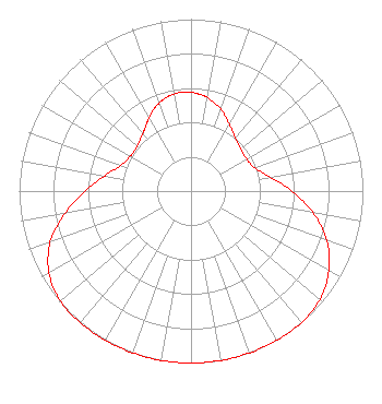 | ||||||||||||||||||
| Azimuth | Ratio | Azimuth | Ratio | Azimuth | Ratio | Azimuth | Ratio | ||||||||||||
| 0 | 0.574 | 5 | 0.565 | 10 | 0.551 | 20 | 0.506 | ||||||||||||
| 30 | 0.447 | 40 | 0.402 | 50 | 0.379 | 60 | 0.374 | ||||||||||||
| 70 | 0.394 | 80 | 0.469 | 90 | 0.589 | 100 | 0.722 | ||||||||||||
| 110 | 0.841 | 120 | 0.926 | 130 | 0.980 | 140 | 1.000 | ||||||||||||
| 150 | 1.000 | 160 | 1.000 | 170 | 1.000 | 180 | 1.000 | ||||||||||||
| 190 | 1.000 | 200 | 1.000 | 210 | 1.000 | 220 | 1.000 | ||||||||||||
| 230 | 0.993 | 240 | 0.954 | 250 | 0.872 | 260 | 0.744 | ||||||||||||
| 270 | 0.616 | 280 | 0.509 | 290 | 0.435 | 300 | 0.407 | ||||||||||||
| 310 | 0.407 | 320 | 0.436 | 325 | 0.460 | 330 | 0.490 | ||||||||||||
| 335 | 0.520 | 340 | 0.544 | 345 | 0.562 | 350 | 0.573 | ||||||||||||
| 355 | 0.578 | ||||||||||||||||||
Structure Registration Number 1007399 [ASR Heights Differ from WLXK Application] Structure Type: TOWER Registered To: Educational Media Foundation Structure Address: 103 Walton Dr Mooresboro, NC County Name: Cleveland County ASR Issued: 09/29/2015 Date Built: 01/04/1995 Site Elevation: 268 m (879 ft.) Structure Height: 82 m (269 ft.) Height Overall: 82 m (269 ft.) Overall Height AMSL: 350 m (1148 ft.) FAA Determination: 11/04/1991 FAA Study #: 91-ASO-0979-OE FAA Circular #: 70/7460-1H Paint & Light FAA Chapters: 3, 4, 5, 13 35-13-52.0 N 81-42-56.0 W (NAD 83) 35-13-51.6 N 81-42-56.6 W (Converted to NAD 27) |
5700 West Oaks Blvd. Rocklin, CA 95765 Phone: 916-251-1600 Not-for-Profit | Date: 02/21/1995 Application Certifier GARDNER-WEBB JUNIOR COLLEGE, INC. Gardner-webb Junior College, Inc. P.o. Box 997 106 Emily Lane Boiling Springs, NC 28017 Applicant | |||||||||||||||||