
FCCInfo.com
A Service of Cavell, Mertz & Associates, Inc.
(855) FCC-INFO
|
|
KVST from 09/08/1998 KVST from 12/03/1990 |
|  |
|
||||||||||||||||||
|
|
KVST Channel: 259C3 99.7 MHz Huntsville, Texas Service: FM - A full-service FM station or application. Facility ID: 26858 Fac. Service: FM Status: License 73.215 Station Application Accepted: 11/07/2017 Application Granted: 12/04/2017 File Number: BLH-20171107ACK License Expires: 00/00/0000 Prefix Type: This is a license for a commercial FM station Application Type: License To Cover FCC Website Links: LMS Facility Details This Application CDBS Application Other KVST Applications Other KVST Applications in CDBS Including Superseded Applications Mailing Address Correspondence for KVST Correspondence related to application BLH-20171107ACK Service Contour - Open Street Map or USGS Map (60 dBu) Service Contour - KML / Google Earth (60 dBu) Public Inspection Files Facility Type: FM STATION Class: C3, A Zone II station; with 6kW-25kW ERP and a class contour distance 28km-39km Site Location: 30-36-03.7 N 95-29-02.8 W (NAD 83) Site Location: 30-36-03.0 N 95-29-02.0 W (Converted to NAD 27) Effective Radiated Power: 10.5 kW Transmitter Output Power: 4.4 kW Antenna Center HAAT: 155 m (509 ft.) Antenna Center AMSL: 255 m (837 ft.) Antenna Center HAG: 142 m (466 ft.) Site Elevation: 113 m. (371 ft.) Height Overall*: 152 m (499 ft.) (* As Filed In This Application, may differ from ASR Data, Below.) Directional Antenna Antenna Make/Model: Electronics Research Inc. LP-6E-DA-HW Antenna ID: 127116 Polarization: | |||||||||||||||||||||
| Antenna Data for Antenna Id: 127116 KVST FM File: BLH-20171107ACK Electronics Research Inc. - LP-6E-DA-HW Service: FM | 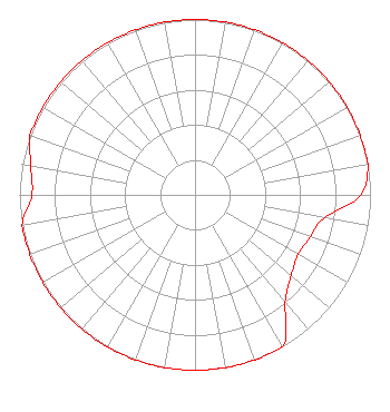 | |||||||||||||||||||||
| Azimuth | Ratio | Azimuth | Ratio | Azimuth | Ratio | Azimuth | Ratio | |||||||||||||||
| 0 | 1.000 | 10 | 1.000 | 20 | 1.000 | 30 | 1.000 | |||||||||||||||
| 40 | 1.000 | 50 | 1.000 | 60 | 1.000 | 70 | 1.000 | |||||||||||||||
| 80 | 1.000 | 90 | 0.944 | 100 | 0.749 | 110 | 0.700 | |||||||||||||||
| 120 | 0.680 | 130 | 0.716 | 140 | 0.800 | 150 | 1.000 | |||||||||||||||
| 160 | 1.000 | 170 | 1.000 | 180 | 1.000 | 190 | 1.000 | |||||||||||||||
| 200 | 1.000 | 210 | 1.000 | 220 | 1.000 | 230 | 1.000 | |||||||||||||||
| 240 | 1.000 | 250 | 1.000 | 260 | 1.000 | 270 | 0.930 | |||||||||||||||
| 280 | 0.950 | 290 | 1.000 | 300 | 1.000 | 310 | 1.000 | |||||||||||||||
| 320 | 1.000 | 330 | 1.000 | 340 | 1.000 | 350 | 1.000 | |||||||||||||||
Structure Registration Number 1293949 Structure Type: GTOWER Registered To: New Wavo Communications Group Structure Address: 1 Km S Of Hwy 75 & Fm 2296 New Waverly, TX County Name: Walker County ASR Issued: 03/23/2017 Date Built: 06/01/2006 Site Elevation: 113.1 m (371 ft.) Structure Height: 152.1 m (499 ft.) Height Overall: 152.1 m (499 ft.) Overall Height AMSL: 265.2 m (870 ft.) FAA Determination: 09/22/2016 FAA Study #: 2016-ASW-8831-OE FAA Circular #: 70/7460-1H Paint & Light FAA Chapters: 3, 4, 5, 13 PRIOR STUDY 2014-ASW-7060-OE 30-36-03.7 N 95-29-02.8 W (NAD 83) 30-36-03.0 N 95-29-02.0 W (Converted to NAD 27) |
14887 Highway 105 West Suite 101 Montgomery, TX 77356 Phone: 936-788-1035 Corporation | Date: 11/07/2017 Application Certifier NEW WAVO COMMUNICATION GROUP, INC. 14887 Highway 105 West Suite 101 Montgomery, TX 77356 Applicant BERT GOLDMAN 560 Perkins Way Auburn, CA 95603 TECHNICAL CONSULTANT FRANK R. JAZZO, ESQUIRE Fletcher, Heald & Hildreth, Pl.c. | ||||||||||||||||||||
|
| |||||||||||||||||||||