
FCCInfo.com
A Service of Cavell, Mertz & Associates, Inc.
(855) FCC-INFO
|
|
WSFP from 07/09/2004 |
|
|
||||||||||||||||
|
|
WSFP Channel: 201C2 88.1 MHz Harrisville, Michigan Service: FM - A full-service FM station or application. Facility ID: 121959 Fac. Service: FM Status: License Application Accepted: 09/20/2013 Application Granted: 09/25/2013 File Number: BLED-20130920ADZ License Expires: 00/00/0000 Prefix Type: This is a license for a noncommercial educational FM station Application Type: License To Cover FCC Website Links: LMS Facility Details This Application CDBS Application Other WSFP Applications Other WSFP Applications in CDBS Including Superseded Applications Mailing Address Correspondence for WSFP Correspondence related to application BLED-20130920ADZ Service Contour - Open Street Map or USGS Map (60 dBu) Service Contour - KML / Google Earth (60 dBu) Public Inspection Files Facility Type: NON-COMMERCIAL EDUC. FM Class: C2, A Zone II station; with 25kW-50kW ERP and a class contour distance 39km-52km Site Location: 44-42-12.0 N 83-31-26.9 W (NAD 83) Site Location: 44-42-12.0 N 83-31-27.0 W (Converted to NAD 27) Effective Radiated Power: 0.001 kW Horiz. ; 18 kW Vert. Transmitter Output Power: 1.25 kW Antenna Center HAAT: 143 m (469 ft.) Antenna Center AMSL: 395 m (1296 ft.) Antenna Center HAG: 90 m (295 ft.) Calculated Site Elevation: 305 m. (1001 ft.) Height Overall*: 93 m (305 ft.) (* As Filed In This Application, may differ from ASR Data, Below.) Directional Antenna Antenna Make/Model: ETC FM-1V-DA Antenna ID: 13373 Polarization:
| ||||||||||||||||||
| Antenna Data for Antenna Id: 13373 WSFP FM File: BLED-20130920ADZ ETC - FM-1V-DA Service: FM | 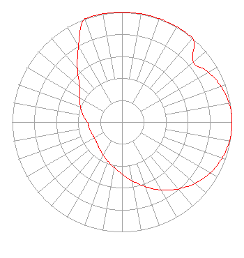 | ||||||||||||||||||
| Azimuth | Ratio | Azimuth | Ratio | Azimuth | Ratio | Azimuth | Ratio | ||||||||||||
| 0 | 1.000 | 10 | 1.000 | 20 | 1.000 | 30 | 1.000 | ||||||||||||
| 40 | 1.000 | 50 | 0.849 | 60 | 0.909 | 70 | 0.957 | ||||||||||||
| 80 | 0.988 | 85 | 1.000 | 90 | 1.000 | 95 | 1.000 | ||||||||||||
| 100 | 0.994 | 110 | 0.969 | 120 | 0.927 | 130 | 0.869 | ||||||||||||
| 140 | 0.796 | 150 | 0.713 | 160 | 0.626 | 170 | 0.543 | ||||||||||||
| 180 | 0.473 | 190 | 0.419 | 200 | 0.379 | 210 | 0.346 | ||||||||||||
| 220 | 0.318 | 230 | 0.297 | 240 | 0.289 | 250 | 0.294 | ||||||||||||
| 260 | 0.304 | 270 | 0.316 | 280 | 0.360 | 290 | 0.403 | ||||||||||||
| 300 | 0.447 | 310 | 0.501 | 320 | 0.631 | 330 | 0.794 | ||||||||||||
| 340 | 1.000 | 350 | 1.000 | ||||||||||||||||
Structure Registration Number 1005821 Structure Type: TOWER Registered To: Queen Bee's Knees, LLC Structure Address: 4 Mi Ene Barton City, MI County Name: Alcona County ASR Issued: 12/13/2023 Date Built: 04/29/1991 Site Elevation: 304.8 m (1000 ft.) Structure Height: 91.4 m (300 ft.) Height Overall: 93 m (305 ft.) Overall Height AMSL: 397.8 m (1305 ft.) FAA Determination: 04/24/1991 FAA Study #: 91-AGL-208-OE Paint & Light FAA Chapters: NONE 44-42-12.0 N 83-31-27.0 W (NAD 83) 44-42-12.0 N 83-31-27.1 W (Converted to NAD 27) |
3302 N. Van Dyke Road Imlay City, MI 48444 Phone: 810-724-2638 | Date: 09/20/2013 Application Certifier MICHIGAN COMMUNITY RADIO 3302 N. Van Dyke Rd. Imlay City, MI 48444 Applicant EDWARD CZELADA 3302 N. Van Dyke Rd. Imlay City, MI 48444 PRESIDENT EDWARD CZELADA Michigan Community Radio | |||||||||||||||||