
FCCInfo.com
A Service of Cavell, Mertz & Associates, Inc.
(855) FCC-INFO
|
|
K283CM from 01/08/2004 |
|
|
||||||||||||||||
|
|
K283CM Channel: 283D 104.5 MHz Auburn, California Service: FX - A translator or application for a translator. Facility ID: 151372 Fac. Service: FX Programming Delivery Method: Unspecified Status: License Application Accepted: 03/01/2018 Application Granted: 04/05/2018 File Number: BLFT-20180301ABA License Expires: 00/00/0000 Prefix Type: This is a license for a translator Application Type: License To Cover FCC Website Links: LMS Facility Details This Application CDBS Application Other K283CM Applications Other K283CM Applications in CDBS Including Superseded Applications Mailing Address Correspondence for K283CM Correspondence related to application BLFT-20180301ABA Service Contour - Open Street Map or USGS Map (60 dBu) Service Contour - KML / Google Earth (60 dBu) Class: D, A Noncommercial educational operating with no more than 10W Site Location: 38-51-27.6 N 121-01-38.8 W (NAD 83) Site Location: 38-51-28.0 N 121-01-35.0 W (Converted to NAD 27) Effective Radiated Power: 0.25 kW Transmitter Output Power: 0.49 kW Antenna Center HAAT: 0 m Antenna Center AMSL: 549 m (1801 ft.) Antenna Center HAG: 64 m (210 ft.) Site Elevation: 485 m. (1591 ft.) Height Overall*: 66 m (217 ft.) (* As Filed In This Application, may differ from ASR Data, Below.) Directional Antenna Antenna Make/Model: None Antenna ID: 130550 Polarization:
| ||||||||||||||||||
| Antenna Data for Antenna Id: 130550 K283CM FX File: BLFT-20180301ABA None - Service: FX | 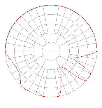 | ||||||||||||||||||
| Azimuth | Ratio | Azimuth | Ratio | Azimuth | Ratio | Azimuth | Ratio | ||||||||||||
| 0 | 1.000 | 10 | 1.000 | 20 | 1.000 | 30 | 1.000 | ||||||||||||
| 40 | 1.000 | 50 | 1.000 | 60 | 1.000 | 70 | 1.000 | ||||||||||||
| 80 | 1.000 | 90 | 1.000 | 100 | 0.679 | 110 | 0.543 | ||||||||||||
| 120 | 1.000 | 130 | 1.000 | 140 | 0.524 | 150 | 0.439 | ||||||||||||
| 160 | 0.632 | 170 | 1.000 | 180 | 1.000 | 190 | 1.000 | ||||||||||||
| 200 | 0.934 | 210 | 1.000 | 220 | 1.000 | 230 | 0.879 | ||||||||||||
| 240 | 0.833 | 250 | 0.860 | 260 | 0.913 | 270 | 1.000 | ||||||||||||
| 280 | 1.000 | 290 | 1.000 | 300 | 1.000 | 310 | 1.000 | ||||||||||||
| 320 | 1.000 | 330 | 1.000 | 340 | 1.000 | 350 | 1.000 | ||||||||||||
Structure Registration Number 1015141 Structure Type: GTOWER Registered To: Vertical Bridge CC AM, LLC Structure Address: Twr 1 Catecroft Lane Pilot Hill, CA County Name: El Dorado County ASR Issued: 11/08/2018 Date Built: 01/01/1985 Site Elevation: 485.2 m (1592 ft.) Structure Height: 66.4 m (218 ft.) Height Overall: 66.4 m (218 ft.) Overall Height AMSL: 551.6 m (1810 ft.) FAA Determination: 08/14/2017 FAA Study #: 2016-AWP-6393-OE Paint & Light FAA Chapters: 1 PRIOR STUDY 2015-AWP-8301-OEMARKED/LIGHTED WITH ORANGE AND WHITE PAINT. 38-51-27.9 N 121-01-38.7 W (NAD 83) 38-51-28.3 N 121-01-34.9 W (Converted to NAD 27) |
985 Lincoln Way Suite 103 Auburn, CA 95603 Phone: 530-885-5653 | Date: 03/01/2018 Application Certifier KAHI CORPORATION 985 Lincoln Way Suite 103 Auburn, CA 95603 Applicant GENE WISNIEWSKI 1472 E 3100 S Wendell, ID 83355 CONSULTING ENGINEER BRADLEY SMITH Kahi Corporation 985 Lincoln Way Suite 103 Auburn, CA 95603 | |||||||||||||||||