
FCCInfo.com
A Service of Cavell, Mertz & Associates, Inc.
(855) FCC-INFO
|
|
W272CG from 07/27/2004 |
|
|
||||||||||||||||
|
|
W272CG Channel: 272D 102.3 MHz Sanford, Maine Service: FX - A translator or application for a translator. Facility ID: 148888 Fac. Service: FX Programming Delivery Method: Unspecified Status: License Application Accepted: 05/14/2019 Application Granted: 05/16/2019 File Number: BLFT-20190514AAD License Expires: 00/00/0000 Prefix Type: This is a license for a translator Application Type: License To Cover FCC Website Links: LMS Facility Details This Application CDBS Application Other W272CG Applications Other W272CG Applications in CDBS Including Superseded Applications Mailing Address Correspondence for W272CG Correspondence related to application BLFT-20190514AAD Service Contour - Open Street Map or USGS Map (60 dBu) Service Contour - KML / Google Earth (60 dBu) Class: D, A Noncommercial educational operating with no more than 10W Site Location: 43-25-00.3 N 70-48-15.2 W (NAD 83) Site Location: 43-25-00.0 N 70-48-17.0 W (Converted to NAD 27) Effective Radiated Power: 0.25 kW Transmitter Output Power: 0.256 kW Antenna Center HAAT: 0 m Antenna Center AMSL: 322 m (1056 ft.) Antenna Center HAG: 130 m (427 ft.) Site Elevation: 192 m. (630 ft.) Height Overall*: 163 m (535 ft.) (* As Filed In This Application, may differ from ASR Data, Below.) Directional Antenna Antenna Make/Model: None Antenna ID: 134468 Polarization:
| ||||||||||||||||||
| Antenna Data for Antenna Id: 134468 W272CG FX File: BLFT-20190514AAD None - Service: FX | 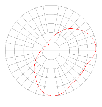 | ||||||||||||||||||
| Azimuth | Ratio | Azimuth | Ratio | Azimuth | Ratio | Azimuth | Ratio | ||||||||||||
| 0 | 0.266 | 10 | 0.326 | 20 | 0.401 | 30 | 0.516 | ||||||||||||
| 40 | 0.633 | 50 | 0.729 | 60 | 0.837 | 70 | 0.923 | ||||||||||||
| 80 | 0.972 | 90 | 0.972 | 100 | 0.916 | 110 | 0.842 | ||||||||||||
| 120 | 0.833 | 130 | 0.832 | 140 | 0.842 | 150 | 0.863 | ||||||||||||
| 160 | 0.936 | 170 | 0.986 | 180 | 0.991 | 190 | 0.934 | ||||||||||||
| 200 | 0.823 | 210 | 0.674 | 220 | 0.569 | 230 | 0.466 | ||||||||||||
| 240 | 0.377 | 250 | 0.304 | 260 | 0.254 | 270 | 0.206 | ||||||||||||
| 280 | 0.162 | 290 | 0.163 | 300 | 0.167 | 310 | 0.151 | ||||||||||||
| 320 | 0.126 | 330 | 0.126 | 340 | 0.152 | 350 | 0.209 | ||||||||||||
Structure Registration Number 1037792 Structure Type: GTOWER Registered To: Maine Public Broadcasting Corp Structure Address: Mount Hope Rd Sanford, ME County Name: York County ASR Issued: 07/02/2019 Date Built: 04/24/2018 Site Elevation: 192 m (630 ft.) Structure Height: 152 m (499 ft.) Height Overall: 163.3 m (536 ft.) Overall Height AMSL: 355.3 m (1166 ft.) FAA Determination: 04/18/2018 FAA Study #: 2018-ANE-708-OE FAA Circular #: 70/7460-1L Paint & Light FAA Chapters: 3, 4, 5, 12 PRIOR STUDY 2002-ANE-811-OE 43-25-00.3 N 70-48-15.2 W (NAD 83) 43-25-00.0 N 70-48-17.0 W (Converted to NAD 27) |
1450 Lisbon St Lewiston, ME 04240 Phone: 207-783-9101 | Date: 05/14/2019 Application Certifier MAINE PUBLIC BROADCASTING CORPORATION 1450 Lisbon Street Lewiston, ME 04240 Applicant GRAY FRIERSON HAERTIG 4646 S.w. Council Crest Drive Portland, OR 97239 ENGINEERING COUNSEL BARRY S. PERSH Gray Miller Persh Llp 2233 Wisconsin Avenue Nw Suite 226 Washington, DC 20007 | |||||||||||||||||