
FCCInfo.com
A Service of Cavell, Mertz & Associates, Inc.
(855) FCC-INFO
|
|
K260DD from 07/01/2004 |
|
|
||||||||||||||||
|
|
K260DD Channel: 260D 99.9 MHz Houston, Texas Service: FX - A translator or application for a translator. Facility ID: 147130 Fac. Service: FX Programming Delivery Method: Unspecified Status: License Application Accepted: 02/14/2018 Application Granted: 11/28/2018 File Number: BLFT-20180214AAT License Expires: 00/00/0000 Prefix Type: This is a license for a translator Application Type: License To Cover FCC Website Links: LMS Facility Details This Application CDBS Application Other K260DD Applications Other K260DD Applications in CDBS Including Superseded Applications Mailing Address Correspondence for K260DD Correspondence related to application BLFT-20180214AAT Service Contour - Open Street Map or USGS Map (60 dBu) Service Contour - KML / Google Earth (60 dBu) Class: D, A Noncommercial educational operating with no more than 10W Site Location: 30-04-58.8 N 95-43-54.8 W (NAD 83) Site Location: 30-04-58.0 N 95-43-54.0 W (Converted to NAD 27) Effective Radiated Power: 0.15 kW Transmitter Output Power: 0.2 kW Antenna Center HAAT: 0 m Antenna Center AMSL: 201 m (659 ft.) Antenna Center HAG: 132 m (433 ft.) Site Elevation: 69 m. (226 ft.) Height Overall*: 149 m (489 ft.) (* As Filed In This Application, may differ from ASR Data, Below.) Directional Antenna Antenna Make/Model: None Antenna ID: 129220 Polarization:
| ||||||||||||||||||
| Antenna Data for Antenna Id: 129220 K260DD FX File: BLFT-20180214AAT None - Service: FX Pattern and Field Values Include a 200° Clockwise Rotation | 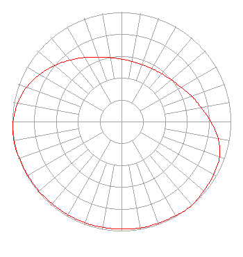 | ||||||||||||||||||
| Azimuth | Ratio | Azimuth | Ratio | Azimuth | Ratio | Azimuth | Ratio | ||||||||||||
| 0 | 0.571 | 10 | 0.558 | 20 | 0.553 | 30 | 0.558 | ||||||||||||
| 40 | 0.571 | 50 | 0.594 | 60 | 0.628 | 70 | 0.682 | ||||||||||||
| 80 | 0.738 | 90 | 0.815 | 100 | 0.897 | 110 | 0.953 | ||||||||||||
| 120 | 0.973 | 130 | 0.983 | 140 | 1.000 | 145 | 1.000 | ||||||||||||
| 150 | 0.992 | 160 | 0.988 | 170 | 0.988 | 180 | 0.983 | ||||||||||||
| 190 | 0.983 | 200 | 0.983 | 210 | 0.983 | 220 | 0.983 | ||||||||||||
| 230 | 0.988 | 240 | 0.988 | 250 | 0.992 | 255 | 1.000 | ||||||||||||
| 260 | 1.000 | 270 | 0.991 | 280 | 0.963 | 290 | 0.923 | ||||||||||||
| 300 | 0.862 | 310 | 0.797 | 320 | 0.731 | 330 | 0.676 | ||||||||||||
| 340 | 0.628 | 350 | 0.594 | ||||||||||||||||
Structure Registration Number 1050821 Structure Type: GTOWER Registered To: American Towers LLC Structure Address: 19734 Fm 2920 (tomball Rosehill #004277) Tomball, TX County Name: Harris County ASR Issued: 12/13/2022 Date Built: 04/13/2011 Site Elevation: 68.9 m (226 ft.) Structure Height: 147.2 m (483 ft.) Height Overall: 148.7 m (488 ft.) Overall Height AMSL: 217.6 m (714 ft.) FAA Determination: 12/05/2022 FAA Study #: 2022-ASW-3529-OE FAA Circular #: 70/7460-1K Paint & Light FAA Chapters: 4, 8, 12 OM&L to remain the same as prior study = A MED-DUAL SYSTEM 30-04-58.3 N 95-43-55.2 W (NAD 83) 30-04-57.5 N 95-43-54.4 W (Converted to NAD 27) |
912 Curtis St. Pasadena, TX 77502 Phone: 713-589-1336 | Date: 02/14/2018 Application Certifier ALELUYA BROADCASTING NETWORK 1600 Pasadena Blvd. Pasadena, TX 77502 Applicant RUBEN VILLARREAL 1600 Pasadena Blvd. Pasadena, TX 77502 OFFICER DAN J. ALPERT The Law Office Of Dan J. Alpert 2120 N. 21st Rd. Arlington, VA 22201 | |||||||||||||||||