
FCCInfo.com
A Service of Cavell, Mertz & Associates, Inc.
(855) FCC-INFO
|
|
|
|
|
||||||||||||||||
|
|
W282AF Channel: 282D 104.3 MHz Concord, New Hampshire Service: FX - A translator or application for a translator. Facility ID: 82567 Fac. Service: FX Programming Delivery Method: Unspecified Status: License Application Accepted: 09/11/2018 Application Granted: 10/01/2018 File Number: BLFT-20180911AAQ License Expires: 00/00/0000 Prefix Type: This is a license for a translator Application Type: License To Cover FCC Website Links: LMS Facility Details This Application CDBS Application Other W282AF Applications Other W282AF Applications in CDBS Including Superseded Applications Mailing Address Correspondence for W282AF Correspondence related to application BLFT-20180911AAQ Service Contour - Open Street Map or USGS Map (60 dBu) Service Contour - KML / Google Earth (60 dBu) Class: D, A Noncommercial educational operating with no more than 10W Site Location: 43-13-08.3 N 71-26-24.3 W (NAD 83) Site Location: 43-13-08.0 N 71-26-26.1 W (Converted to NAD 27) Effective Radiated Power: 0.01 kW Transmitter Output Power: 0.024 kW Antenna Center HAAT: 0 m Antenna Center AMSL: 316 m (1037 ft.) Antenna Center HAG: 15 m (49 ft.) Site Elevation: 301 m. (988 ft.) Height Overall*: 33 m (108 ft.) (* As Filed In This Application, may differ from ASR Data, Below.) Directional Antenna Antenna Make/Model: None Antenna ID: 133407 Polarization:
| ||||||||||||||||||
| Antenna Data for Antenna Id: 133407 W282AF FX File: BLFT-20180911AAQ None - Service: FX | 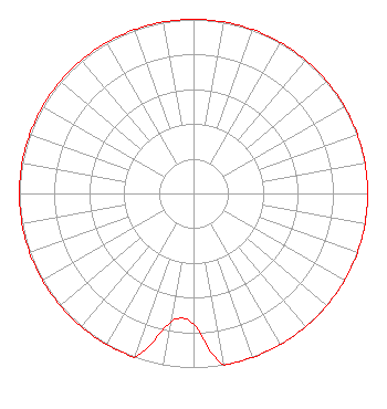 | ||||||||||||||||||
| Azimuth | Ratio | Azimuth | Ratio | Azimuth | Ratio | Azimuth | Ratio | ||||||||||||
| 0 | 1.000 | 10 | 1.000 | 20 | 1.000 | 30 | 1.000 | ||||||||||||
| 40 | 1.000 | 50 | 1.000 | 60 | 1.000 | 70 | 1.000 | ||||||||||||
| 80 | 1.000 | 90 | 1.000 | 100 | 1.000 | 110 | 1.000 | ||||||||||||
| 120 | 1.000 | 130 | 1.000 | 140 | 1.000 | 150 | 1.000 | ||||||||||||
| 160 | 1.000 | 170 | 1.000 | 180 | 0.750 | 190 | 0.750 | ||||||||||||
| 200 | 1.000 | 210 | 1.000 | 220 | 1.000 | 230 | 1.000 | ||||||||||||
| 240 | 1.000 | 250 | 1.000 | 260 | 1.000 | 270 | 1.000 | ||||||||||||
| 280 | 1.000 | 290 | 1.000 | 300 | 1.000 | 310 | 1.000 | ||||||||||||
| 320 | 1.000 | 330 | 1.000 | 340 | 1.000 | 350 | 1.000 | ||||||||||||
Structure Registration Number 1302875 Structure Type: GTOWER Registered To: Capital Area Repeater Society Structure Address: 885 Plausawa Hill Rad (atc Site # 373106) Pembroke, NH County Name: Merrimack County ASR Issued: 05/03/2018 Date Built: 09/01/1990 Site Elevation: 301.4 m (989 ft.) Structure Height: 26.5 m (87 ft.) Height Overall: 32.6 m (107 ft.) Overall Height AMSL: 334 m (1096 ft.) FAA Determination: 07/19/2017 FAA Study #: 2017-ANE-1417-OE Paint & Light FAA Chapters: NONE 43-13-07.9 N 71-26-24.6 W (NAD 83) 43-13-07.6 N 71-26-26.4 W (Converted to NAD 27) |
10 Ferry Street Suite 424 Concord, NH 03301 Phone: 603-227-0911 Corporation | Date: 09/11/2018 Application Certifier CONCORD BIBLE FELLOWSHIP 25 Rockingham Street Concord, NH 03301 Applicant JUSTIN ASHER Asher Broadcast Consulting, Llc 579 Babcock Road Bronson, MI 49028-9347 TECHNICAL CONSULTANT MATTHEW H. MCCORMICK Fletcher, Heald & Hildreth, P.l.c. 1300 North 17th Street 11th Floor Arlington, VA 22209 | |||||||||||||||||