
FCCInfo.com
A Service of Cavell, Mertz & Associates, Inc.
(855) FCC-INFO
|
|
WKVN from 11/01/2006 WKVN from 03/28/1979 |
|
|
||||||||||||||||
|
|
WKVN Channel: 237C3 95.3 MHz Corydon, Kentucky Service: FM - A full-service FM station or application. Facility ID: 68810 Fac. Service: FM Status: License 73.215 Station Application Accepted: 09/11/2019 Application Granted: 09/24/2019 File Number: BMLED-20190911ABT License Expires: 00/00/0000 Prefix Type: This is a modification of license for a noncommercial educational FM station Application Type: Minor Modification FCC Website Links: LMS Facility Details This Application CDBS Application Other WKVN Applications Other WKVN Applications in CDBS Including Superseded Applications Mailing Address Correspondence for WKVN Correspondence related to application BMLED-20190911ABT Service Contour - Open Street Map or USGS Map (60 dBu) Service Contour - KML / Google Earth (60 dBu) Public Inspection Files History Cards for WKVN Facility Type: NON-COMMERCIAL EDUC. FM Class: C3, A Zone II station; with 6kW-25kW ERP and a class contour distance 28km-39km Site Location: 37-46-38.2 N 87-37-26.1 W (NAD 83) Site Location: 37-46-38.0 N 87-37-26.1 W (Converted to NAD 27) Effective Radiated Power: 25 kW Transmitter Output Power: 9.67 kW Antenna Center HAAT: 82 m (269 ft.) Antenna Center AMSL: 206 m (676 ft.) Antenna Center HAG: 81 m (266 ft.) Calculated Site Elevation: 125 m. (410 ft.) Height Overall*: 94.5 m (310 ft.) (* As Filed In This Application, may differ from ASR Data, Below.) Directional Antenna Antenna Make/Model: DIELECTRIC DCRM4E75D Antenna ID: 65225 Polarization: | ||||||||||||||||||
| Antenna Data for Antenna Id: 65225 WKVN FM File: BMLED-20190911ABT DIELECTRIC - DCRM4E75D Service: FM | 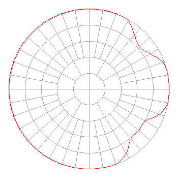 | ||||||||||||||||||
| Azimuth | Ratio | Azimuth | Ratio | Azimuth | Ratio | Azimuth | Ratio | ||||||||||||
| 0 | 1.000 | 10 | 1.000 | 20 | 1.000 | 30 | 0.980 | ||||||||||||
| 40 | 0.880 | 50 | 0.820 | 60 | 0.880 | 70 | 0.980 | ||||||||||||
| 80 | 1.000 | 90 | 1.000 | 100 | 1.000 | 110 | 0.930 | ||||||||||||
| 120 | 0.810 | 130 | 0.810 | 140 | 0.810 | 150 | 0.930 | ||||||||||||
| 160 | 1.000 | 170 | 1.000 | 180 | 1.000 | 190 | 1.000 | ||||||||||||
| 200 | 1.000 | 210 | 1.000 | 220 | 1.000 | 230 | 1.000 | ||||||||||||
| 240 | 1.000 | 250 | 1.000 | 260 | 1.000 | 270 | 1.000 | ||||||||||||
| 280 | 1.000 | 290 | 1.000 | 300 | 1.000 | 310 | 1.000 | ||||||||||||
| 320 | 1.000 | 330 | 1.000 | 340 | 1.000 | 350 | 1.000 | ||||||||||||
Structure Registration Number 1238470 Structure Type: TOWER Registered To: Verizon Americas LLC Structure Address: 6454 Highway 41-a Henderson, KY County Name: Henderson County ASR Issued: 08/06/2020 Date Built: 09/24/2003 Site Elevation: 125 m (410 ft.) Structure Height: 91.4 m (300 ft.) Height Overall: 94.5 m (310 ft.) Overall Height AMSL: 219.5 m (720 ft.) FAA Determination: 09/16/2003 FAA Study #: 2003-AGL-4467-OE FAA Circular #: 70/7460-1K Paint & Light FAA Chapters: 4, 8, 12 OM&L to remain the same as prior study = A MED-DUAL SYSTEM 37-46-37.6 N 87-37-25.5 W (NAD 83) 37-46-37.4 N 87-37-25.5 W (Converted to NAD 27) |
5700 West Oaks Blvd. Rocklin, CA 95765 Phone: 916-251-1600 Not-for-Profit | Date: 09/11/2019 Application Certifier EDUCATIONAL MEDIA FOUNDATION 5700 West Oaks Blvd. Rocklin, CA 95765 Applicant LINDA ADAMS 5700 West Oaks Blvd. Rocklin, CA 95765 TECHNICAL CONSULTANT MARY N. O'CONNOR Wilkinson Barker Knauer, Llp | |||||||||||||||||