
FCCInfo.com
A Service of Cavell, Mertz & Associates, Inc.
(855) FCC-INFO
|
|
W299BH from 09/09/2004 |
|
|
||||||||||||||||
|
|
W299BH Channel: 299D 107.7 MHz Marshallton, Delaware Service: FX - A translator or application for a translator. Facility ID: 142393 Fac. Service: FX Programming Delivery Method: Unspecified Status: License Application Accepted: 05/11/2007 Application Granted: 06/12/2007 File Number: BLFT-20070511AAX License Expires: 00/00/0000 Prefix Type: This is a license for a translator Application Type: License To Cover FCC Website Links: LMS Facility Details This Application CDBS Application Other W299BH Applications Other W299BH Applications in CDBS Including Superseded Applications Mailing Address Correspondence for W299BH Correspondence related to application BLFT-20070511AAX Service Contour - Open Street Map or USGS Map (60 dBu) Service Contour - KML / Google Earth (60 dBu) Class: D, A Noncommercial educational operating with no more than 10W Site Location: 39-42-31.0 N 75-33-58.0 W (NAD 83) Site Location: 39-42-30.6 N 75-33-59.3 W (Converted to NAD 27) Effective Radiated Power: 0.25 kW Transmitter Output Power: 0.245 kW Antenna Center HAAT: 49.5 m Horiz.; 0 m Vert. Antenna Center AMSL: 74 m (243 ft.) Antenna Center HAG: 55 m (180 ft.) Site Elevation: 19 m. (62 ft.) Height Overall*: 73 m (240 ft.) (* As Filed In This Application, may differ from ASR Data, Below.) Directional Antenna Antenna Make/Model: None Antenna ID: 16125 Polarization:
| ||||||||||||||||||
| Antenna Data for Antenna Id: 16125 W299BH FX File: BLFT-20070511AAX None - Service: FX Pattern and Field Values Include a 316° Clockwise Rotation | 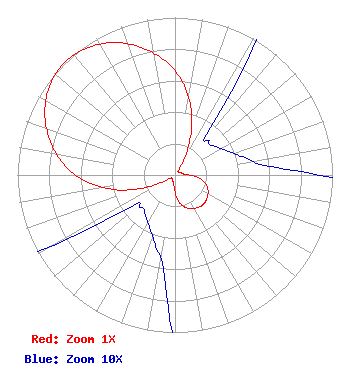 | ||||||||||||||||||
| Azimuth | Ratio | Azimuth | Ratio | Azimuth | Ratio | Azimuth | Ratio | ||||||||||||
| 6 | 0.570 | 16 | 0.388 | 26 | 0.187 | 36 | 0.045 | ||||||||||||
| 46 | 0.030 | 56 | 0.032 | 66 | 0.037 | 76 | 0.046 | ||||||||||||
| 86 | 0.065 | 96 | 0.142 | 106 | 0.202 | 116 | 0.234 | ||||||||||||
| 126 | 0.250 | 136 | 0.260 | 146 | 0.250 | 156 | 0.234 | ||||||||||||
| 166 | 0.202 | 176 | 0.142 | 186 | 0.065 | 196 | 0.046 | ||||||||||||
| 206 | 0.037 | 216 | 0.032 | 226 | 0.030 | 236 | 0.045 | ||||||||||||
| 246 | 0.187 | 256 | 0.388 | 266 | 0.570 | 276 | 0.715 | ||||||||||||
| 286 | 0.829 | 296 | 0.920 | 306 | 0.979 | 316 | 1.000 | ||||||||||||
| 326 | 0.979 | 336 | 0.920 | 346 | 0.829 | 356 | 0.715 | ||||||||||||
Structure Registration Number 1060184 [ASR Heights Differ from W299BH Application] Structure Type: TOWER Registered To: State of Delaware Div. of Coms Structure Address: 3601 North Dupont Hwy New Castle, DE County Name: New Castle County ASR Issued: 08/09/2023 Date Built: 04/19/1996 Site Elevation: 18.5 m (61 ft.) Structure Height: 60.9 m (200 ft.) Height Overall: 73.2 m (240 ft.) Overall Height AMSL: 91.7 m (301 ft.) FAA Determination: 12/21/1998 FAA Study #: 96-AEA-2715-OE FAA Circular #: 70/7460-1J Paint & Light FAA Chapters: 4, 8, 13 39-42-31.0 N 75-33-58.0 W (NAD 83) 39-42-30.6 N 75-33-59.3 W (Converted to NAD 27) |
1509 Cecil B. Moore Avenue Wrti/third Floor Philadelphia, PA 19121-3410 Phone: 215-204-8405 | Date: 05/11/2007 Application Certifier TEMPLE UNIVERSITY OF THE COMMONWEALTH SYSTEM OF HIGHER ED 1509 Cecil B. Moore Avenue Wrti/third Floor Philadelphia, PA 19121-3410 Applicant JEFF DEPOLO Broadcast Sciences 1465 Horseshoe Trail Malvern, PA 19355 CONSULTANT PETER TANNENWALD Irwin, Campbell & Tannenwald, P.c. 1730 Rhode Island Ave., Nw Suite 200 Washington, DC 20036-3120 | |||||||||||||||||