
FCCInfo.com
A Service of Cavell, Mertz & Associates, Inc.
(855) FCC-INFO
|
|
KOSY-FM from 01/17/2012 KOSY-FM from 04/19/2007 |
|
|
||||||||||||||||
|
|
KOSY-FM Channel: 239C3 95.7 MHz Anamosa, Iowa Service: FM - A full-service FM station or application. Facility ID: 162475 Fac. Service: FM Status: License 73.215 Station Application Accepted: 07/10/2015 Application Granted: 07/23/2015 File Number: BLH-20150710ABF License Expires: 00/00/0000 Prefix Type: This is a license for a commercial FM station Application Type: License To Cover FCC Website Links: LMS Facility Details This Application CDBS Application Other KOSY-FM Applications Other KOSY-FM Applications in CDBS Including Superseded Applications Mailing Address Correspondence for KOSY-FM Correspondence related to application BLH-20150710ABF Service Contour - Open Street Map or USGS Map (60 dBu) Service Contour - KML / Google Earth (60 dBu) Public Inspection Files Facility Type: FM STATION Class: C3, A Zone II station; with 6kW-25kW ERP and a class contour distance 28km-39km Site Location: 42-03-39.0 N 91-32-36.0 W (NAD 83) Site Location: 42-03-39.0 N 91-32-35.4 W (Converted to NAD 27) Effective Radiated Power: 18 kW Transmitter Output Power: 8.82 kW Antenna Center HAAT: 118 m (387 ft.) Antenna Center AMSL: 373 m (1224 ft.) Antenna Center HAG: 111 m (364 ft.) Calculated Site Elevation: 262 m. (860 ft.) Height Overall*: 129 m (423 ft.) (* As Filed In This Application, may differ from ASR Data, Below.) Directional Antenna Antenna Make/Model: Electronics Research Inc. LP-4E-DA, four sections Antenna ID: 109334 Polarization: | ||||||||||||||||||
| Antenna Data for Antenna Id: 109334 KOSY-FM FM File: BLH-20150710ABF Electronics Research Inc. - LP-4E-DA, four sections Service: FM | 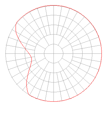 | ||||||||||||||||||
| Azimuth | Ratio | Azimuth | Ratio | Azimuth | Ratio | Azimuth | Ratio | ||||||||||||
| 0 | 1.000 | 10 | 1.000 | 20 | 1.000 | 30 | 1.000 | ||||||||||||
| 40 | 1.000 | 50 | 1.000 | 60 | 1.000 | 70 | 1.000 | ||||||||||||
| 80 | 1.000 | 90 | 1.000 | 100 | 1.000 | 110 | 1.000 | ||||||||||||
| 120 | 1.000 | 130 | 1.000 | 140 | 1.000 | 150 | 1.000 | ||||||||||||
| 160 | 1.000 | 170 | 1.000 | 180 | 1.000 | 190 | 1.000 | ||||||||||||
| 200 | 1.000 | 210 | 1.000 | 220 | 0.870 | 230 | 0.696 | ||||||||||||
| 240 | 0.559 | 250 | 0.487 | 260 | 0.470 | 270 | 0.510 | ||||||||||||
| 280 | 0.600 | 290 | 0.739 | 300 | 0.900 | 310 | 1.000 | ||||||||||||
| 320 | 1.000 | 330 | 1.000 | 340 | 1.000 | 350 | 1.000 | ||||||||||||
Structure Registration Number 1024392 Structure Type: GTOWER Registered To: Vertical Bridge CC FM, LLC Structure Address: Twr 2 1837 Radio Road Marion, IA County Name: Linn County ASR Issued: 11/08/2018 Date Built: 01/01/1941 Site Elevation: 262.1 m (860 ft.) Structure Height: 128 m (420 ft.) Height Overall: 129.1 m (424 ft.) Overall Height AMSL: 391.2 m (1283 ft.) FAA Determination: 07/26/2016 FAA Study #: 2016-ACE-1-OE FAA Circular #: 70/7460-1L Paint & Light FAA Chapters: 4, 8, 12 PRIOR STUDY 1997-ACE-502-OE 42-03-39.0 N 91-32-35.8 W (NAD 83) 42-03-39.0 N 91-32-35.2 W (Converted to NAD 27) |
7136 S. Yale Avenue Suite 501 Tulsa, OK 74136 Phone: 918-664-4581 | Date: 07/10/2015 Application Certifier CITICASTERS LICENSES, INC. 7136 S. Yale Avenue Suite 501 Tulsa, OK 74136-2623 Applicant TROY G. LANGHAM 2625 South Memorial Drive Suite A Tulsa, OK 74129 FCC ENGINEERING SUPERVISOR TROY G. LANGHAM Iheartmedia, Inc. | |||||||||||||||||