
FCCInfo.com
A Service of Cavell, Mertz & Associates, Inc.
(855) FCC-INFO
|
|
K230AZ from 01/24/1990 K230AZ from 10/30/1987 |
|
|
||||||||||||||||
|
|
K230AZ Channel: 230D 93.9 MHz Glenwood Springs, Colorado Service: FX - A translator or application for a translator. Facility ID: 53154 Fac. Service: FX Programming Delivery Method: Unspecified Status: License Application Accepted: 03/17/2009 Application Granted: 04/08/2009 File Number: BLFT-20090317AAB License Expires: 00/00/0000 Prefix Type: This is a license for a translator Application Type: License To Cover FCC Website Links: LMS Facility Details This Application CDBS Application Other K230AZ Applications Other K230AZ Applications in CDBS Including Superseded Applications Mailing Address Correspondence for K230AZ Correspondence related to application BLFT-20090317AAB Service Contour - Open Street Map or USGS Map (60 dBu) Service Contour - KML / Google Earth (60 dBu) Class: D, A Noncommercial educational operating with no more than 10W Site Location: 39-33-42.9 N 107-19-03.2 W (NAD 83) Site Location: 39-33-43.0 N 107-19-01.0 W (Converted to NAD 27) Effective Radiated Power: 0 kW Horiz. ; 0.019 kW Vert. Transmitter Output Power: 0.016 kW Antenna Center HAAT: 0 m Horiz.; -209.7 m Vert. Antenna Center AMSL: 0 m Horiz.; 2215 m Vert. Antenna Center HAG: 0 m Horiz.; 9 m Vert. Site Elevation: 2206 m. (7238 ft.) Height Overall*: 12 m (39 ft.) (* As Filed In This Application, may differ from ASR Data, Below.) Directional Antenna Antenna Make/Model: None Antenna ID: 89641 Polarization:
| ||||||||||||||||||
| Antenna Data for Antenna Id: 89641 K230AZ FX File: BLFT-20090317AAB None - Service: FX Pattern and Field Values Include a 90° Clockwise Rotation | 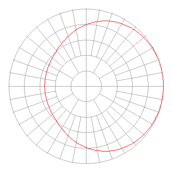 | ||||||||||||||||||
| Azimuth | Ratio | Azimuth | Ratio | Azimuth | Ratio | Azimuth | Ratio | ||||||||||||
| 0 | 0.792 | 10 | 0.845 | 20 | 0.892 | 30 | 0.929 | ||||||||||||
| 40 | 0.956 | 50 | 0.975 | 60 | 0.987 | 70 | 0.995 | ||||||||||||
| 80 | 0.999 | 90 | 1.000 | 100 | 0.999 | 110 | 0.995 | ||||||||||||
| 120 | 0.987 | 130 | 0.975 | 140 | 0.956 | 150 | 0.929 | ||||||||||||
| 160 | 0.892 | 170 | 0.845 | 180 | 0.792 | 190 | 0.735 | ||||||||||||
| 200 | 0.679 | 210 | 0.630 | 220 | 0.592 | 230 | 0.566 | ||||||||||||
| 240 | 0.549 | 250 | 0.540 | 260 | 0.535 | 270 | 0.534 | ||||||||||||
| 280 | 0.535 | 290 | 0.540 | 300 | 0.549 | 310 | 0.566 | ||||||||||||
| 320 | 0.592 | 330 | 0.630 | 340 | 0.679 | 350 | 0.735 | ||||||||||||
Structure Registration Number 1237713 [ASR Heights Differ from K230AZ Application] Structure Type: GTOWER Registered To: POW, INC Structure Address: 1.3 Miles North Of Glenwood Springs, CO County Name: Garfield County ASR Issued: 06/13/2018 Date Built: 10/16/1989 Site Elevation: 2208.6 m (7246 ft.) Structure Height: 11.9 m (39 ft.) Height Overall: 11.9 m (39 ft.) Overall Height AMSL: 2220.5 m (7285 ft.) FAA Determination: 03/19/2018 FAA Study #: 2018-ANM-690-OE Paint & Light FAA Chapters: NONE PRIOR STUDY 2003-ANM-46-OE 39-33-43.3 N 107-19-03.5 W (NAD 83) 39-33-43.4 N 107-19-01.3 W (Converted to NAD 27) |
7409 S. Alton Ct. Centennial, CO 80112 Phone: 303-871-9191 Corporation | Date: 03/17/2009 Application Certifier JOHN DADY 8449 Wax Wing Drive Freeland,, MI 48623 Applicant GENE WISNIEWSKI P. O. Box 5429 Twin Falls, ID 83303 CONSULTING ENGINEER JOHN DADY John Dady 8449 Wax Wing Drive Freeland,, MI 48623 | |||||||||||||||||