
FCCInfo.com
A Service of Cavell, Mertz & Associates, Inc.
(855) FCC-INFO
|
|
|
|
|
||||||||||||||||
|
|
W249DU Channel: 249D 97.7 MHz Moundsville, West Virginia Service: FX - A translator or application for a translator. Facility ID: 200385 Fac. Service: FX Programming Delivery Method: Unspecified Status: License Application Accepted: 02/21/2019 Application Granted: 03/21/2019 File Number: BLFT-20190221AAS License Expires: 00/00/0000 Prefix Type: This is a license for a translator Application Type: License To Cover FCC Website Links: LMS Facility Details This Application CDBS Application Other W249DU Applications Other W249DU Applications in CDBS Including Superseded Applications Mailing Address Correspondence for W249DU Correspondence related to application BLFT-20190221AAS Service Contour - Open Street Map or USGS Map (60 dBu) Service Contour - KML / Google Earth (60 dBu) Class: D, A Noncommercial educational operating with no more than 10W Site Location: 39-54-19.2 N 80-46-42.3 W (NAD 83) Site Location: 39-54-18.9 N 80-46-43.0 W (Converted to NAD 27) Effective Radiated Power: 0.06 kW Transmitter Output Power: 0.12 kW Antenna Center HAAT: 0 m Antenna Center AMSL: 433 m (1421 ft.) Antenna Center HAG: 57 m (187 ft.) Site Elevation: 376 m. (1234 ft.) Height Overall*: 61 m (200 ft.) (* As Filed In This Application, may differ from ASR Data, Below.) Directional Antenna Antenna Make/Model: None Antenna ID: 133051 Polarization:
| ||||||||||||||||||
| Antenna Data for Antenna Id: 133051 W249DU FX File: BLFT-20190221AAS None - Service: FX | 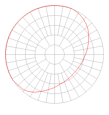 | ||||||||||||||||||
| Azimuth | Ratio | Azimuth | Ratio | Azimuth | Ratio | Azimuth | Ratio | ||||||||||||
| 0 | 1.000 | 10 | 1.000 | 20 | 1.000 | 30 | 0.967 | ||||||||||||
| 40 | 0.927 | 50 | 0.870 | 60 | 0.804 | 70 | 0.736 | ||||||||||||
| 80 | 0.681 | 90 | 0.633 | 100 | 0.597 | 110 | 0.573 | ||||||||||||
| 120 | 0.559 | 130 | 0.553 | 140 | 0.557 | 150 | 0.569 | ||||||||||||
| 160 | 0.592 | 170 | 0.624 | 180 | 0.676 | 190 | 0.732 | ||||||||||||
| 200 | 0.805 | 210 | 0.888 | 220 | 0.950 | 230 | 0.971 | ||||||||||||
| 240 | 1.000 | 250 | 1.000 | 260 | 1.000 | 270 | 1.000 | ||||||||||||
| 280 | 1.000 | 290 | 1.000 | 300 | 1.000 | 310 | 1.000 | ||||||||||||
| 320 | 1.000 | 330 | 1.000 | 340 | 1.000 | 350 | 1.000 | ||||||||||||
Structure Registration Number 1306269 Structure Type: GTOWER Registered To: RCK 1 Group LLC Structure Address: Orchard Lane Moundsville, WV County Name: Marshall County ASR Issued: 05/30/2018 Date Built: 11/01/2012 Site Elevation: 376.4 m (1235 ft.) Structure Height: 60.7 m (199 ft.) Height Overall: 60.7 m (199 ft.) Overall Height AMSL: 437.1 m (1434 ft.) FAA Determination: 05/08/2018 FAA Study #: 2018-AEA-4561-OE Paint & Light FAA Chapters: NONE 39-54-19.2 N 80-46-42.3 W (NAD 83) 39-54-18.9 N 80-46-43.0 W (Converted to NAD 27) |
1609 Warwood Avenue Wheeling, WV 26003 Phone: 304-277-1700 | Date: 02/21/2019 Application Certifier RCK 1 GROUP LLC 1609 Warwood Avenue Wheeling, WV 26003 Applicant CLIFFORD BRYSON 93 Robinhood Drive Cranberry Township, PA 16066 CONTRACT ENGINEER ROBERT L OLENDER ESQ Koerner & Olender Pc 7020 Richard Drive Bethesda, MD 20817 | |||||||||||||||||