
FCCInfo.com
A Service of Cavell, Mertz & Associates, Inc.
(855) FCC-INFO
|
|
WEVN from 02/26/1993 |
|  |
|
||||||||||||||||||
|
|
WEVN Channel: 214B1 90.7 MHz Keene, New Hampshire Service: FM - A full-service FM station or application. Facility ID: 48440 Fac. Service: FM Analog & Digital Status: License Application Accepted: 08/15/2003 Application Granted: 08/31/2004 File Number: BMLED-20030815ADI License Expires: 00/00/0000 Prefix Type: This is a modification of license for a noncommercial educational FM station Application Type: Minor Modification FCC Website Links: LMS Facility Details This Application CDBS Application Other WEVN Applications Other WEVN Applications in CDBS Including Superseded Applications Mailing Address Correspondence for WEVN Correspondence related to application BMLED-20030815ADI Service Contour - Open Street Map or USGS Map (60 dBu) Service Contour - KML / Google Earth (60 dBu) Public Inspection Files Facility Type: NON-COMMERCIAL EDUC. FM Class: B1, A Zone I or I-A station; with 6kW-25kW ERP and a class contour distance 28km-39km Site Location: 43-02-00.3 N 72-22-02.3 W (NAD 83) Site Location: 43-02-00.0 N 72-22-04.0 W (Converted to NAD 27) Effective Radiated Power: 1.5 kW Transmitter Output Power: 0.73 kW Antenna Center HAAT: 286 m (938 ft.) Antenna Center AMSL: 551 m (1808 ft.) Antenna Center HAG: 88 m (289 ft.) Calculated Site Elevation: 463 m. (1519 ft.) Height Overall*: 152 m (499 ft.) (* As Filed In This Application, may differ from ASR Data, Below.) Directional Antenna Antenna Make/Model: Shivley 6810-2R-DA Antenna ID: 14363 Polarization: | |||||||||||||||||||||
| Antenna Data for Antenna Id: 14363 WEVN FM File: BMLED-20030815ADI Shivley - 6810-2R-DA Service: FM | 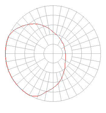 | |||||||||||||||||||||
| Azimuth | Ratio | Azimuth | Ratio | Azimuth | Ratio | Azimuth | Ratio | |||||||||||||||
| 0 | 0.450 | 10 | 0.400 | 20 | 0.360 | 30 | 0.330 | |||||||||||||||
| 40 | 0.300 | 50 | 0.290 | 60 | 0.270 | 70 | 0.260 | |||||||||||||||
| 80 | 0.260 | 90 | 0.260 | 100 | 0.270 | 110 | 0.280 | |||||||||||||||
| 120 | 0.300 | 130 | 0.330 | 140 | 0.390 | 150 | 0.450 | |||||||||||||||
| 160 | 0.540 | 170 | 0.630 | 180 | 0.720 | 190 | 0.810 | |||||||||||||||
| 200 | 0.940 | 210 | 1.000 | 220 | 1.000 | 230 | 1.000 | |||||||||||||||
| 240 | 1.000 | 250 | 1.000 | 260 | 1.000 | 270 | 1.000 | |||||||||||||||
| 280 | 1.000 | 290 | 1.000 | 300 | 0.950 | 310 | 0.870 | |||||||||||||||
| 320 | 0.790 | 330 | 0.710 | 340 | 0.620 | 350 | 0.530 | |||||||||||||||
Structure Registration Number 1034694 [ASR Heights Differ from WEVN Application] Structure Type: TOWER Registered To: New Hampshire Public Broadcasting Structure Address: On Derry Hill 8 Mi Nnw Of Keene Nh Walpole, NH County Name: Cheshire County ASR Issued: 04/08/2021 Date Built: 01/01/1967 Site Elevation: 462.4 m (1517 ft.) Structure Height: 138.7 m (455 ft.) Height Overall: 152.4 m (500 ft.) Overall Height AMSL: 614.8 m (2017 ft.) FAA Determination: 05/27/1997 FAA Study #: 97-ANE-0169-OE Paint & Light FAA Chapters: 1, 3, 4, 13, 21 43-02-00.0 N 72-22-02.0 W (NAD 83) 43-01-59.7 N 72-22-03.7 W (Converted to NAD 27) |
2 Pillsbury Street Suite 600 Concord, NH 03301 Phone: 603-228-8910 | Date: 08/15/2003 Application Certifier NEW HAMPSHIRE PUBLIC RADIO 207 North Main Street Concord, NH 03301 Applicant JOHN HUNTLEY 207 North Main Street Concord, NH 03301 DIRECTOR OF ENGINEERING JOHN CRIGLER Garvey Schubert Barer | ||||||||||||||||||||
| ||||||||||||||||||||||