
FCCInfo.com
A Service of Cavell, Mertz & Associates, Inc.
(855) FCC-INFO
|
|
WBHL from 10/01/2008 WBHL from 09/18/2008 |
|
|
||||||||||||||||
|
|
WBHL Channel: 214C3 90.7 MHz Harrison, Michigan Service: FM - A full-service FM station or application. Facility ID: 174240 Fac. Service: FM Status: License Application Accepted: 10/03/2012 Application Granted: 10/18/2012 File Number: BLED-20121003ACR License Expires: 00/00/0000 Prefix Type: This is a license for a noncommercial educational FM station Application Type: License To Cover FCC Website Links: LMS Facility Details This Application CDBS Application Other WBHL Applications Other WBHL Applications in CDBS Including Superseded Applications Mailing Address Correspondence for WBHL Correspondence related to application BLED-20121003ACR Service Contour - Open Street Map or USGS Map (60 dBu) Service Contour - KML / Google Earth (60 dBu) Public Inspection Files Facility Type: NON-COMMERCIAL EDUC. FM Class: C3, A Zone II station; with 6kW-25kW ERP and a class contour distance 28km-39km Site Location: 43-57-17.1 N 84-32-59.0 W (NAD 83) Site Location: 43-57-17.0 N 84-32-59.0 W (Converted to NAD 27) Effective Radiated Power: 10 kW Transmitter Output Power: 2.85 kW Antenna Center HAAT: 130 m (427 ft.) Antenna Center AMSL: 382 m (1253 ft.) Antenna Center HAG: 130 m (427 ft.) Calculated Site Elevation: 252 m. (827 ft.) Height Overall*: 152 m (499 ft.) (* As Filed In This Application, may differ from ASR Data, Below.) Directional Antenna Antenna Make/Model: None SWR FMH3/4-DA, 4 section Antenna ID: 108860 Polarization: | ||||||||||||||||||
| Antenna Data for Antenna Id: 108860 WBHL FM File: BLED-20121003ACR None - SWR FMH3/4-DA, 4 section Service: FM | 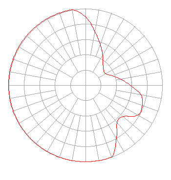 | ||||||||||||||||||
| Azimuth | Ratio | Azimuth | Ratio | Azimuth | Ratio | Azimuth | Ratio | ||||||||||||
| 0 | 0.891 | 10 | 0.708 | 20 | 0.562 | 30 | 0.447 | ||||||||||||
| 40 | 0.355 | 50 | 0.307 | 60 | 0.299 | 70 | 0.365 | ||||||||||||
| 80 | 0.460 | 90 | 0.579 | 100 | 0.729 | 110 | 0.785 | ||||||||||||
| 120 | 0.785 | 130 | 0.638 | 140 | 0.638 | 150 | 0.804 | ||||||||||||
| 160 | 1.000 | 170 | 1.000 | 180 | 1.000 | 190 | 1.000 | ||||||||||||
| 200 | 1.000 | 210 | 1.000 | 220 | 1.000 | 230 | 1.000 | ||||||||||||
| 240 | 1.000 | 250 | 1.000 | 260 | 1.000 | 270 | 1.000 | ||||||||||||
| 280 | 1.000 | 290 | 1.000 | 300 | 1.000 | 310 | 1.000 | ||||||||||||
| 320 | 1.000 | 330 | 1.000 | 340 | 1.000 | 350 | 1.000 | ||||||||||||
Structure Registration Number 1007817 [ASR Heights Differ from WBHL Application] Structure Type: TOWER Registered To: APPLE BROADCASTING INC Structure Address: 1130 Grout Rd Gladwin, MI County Name: Gladwin County ASR Issued: 03/26/2012 Date Built: 12/15/1993 Site Elevation: 251.5 m (825 ft.) Structure Height: 151.2 m (496 ft.) Height Overall: 152.1 m (499 ft.) Overall Height AMSL: 403.6 m (1324 ft.) FAA Determination: 02/24/2012 FAA Study #: 2012-AGL-952-OE FAA Circular #: 70/7460-1J Paint & Light FAA Chapters: 3, 4, 5, 13 OM&L to remain the same as prior study = PAINT/RED LIGHTS 43-57-16.8 N 84-32-58.6 W (NAD 83) 43-57-16.7 N 84-32-58.6 W (Converted to NAD 27) |
Cadillac, MI 49601 Phone: 231-468-2087 Not-for-Profit | Date: 10/03/2012 Application Certifier WEST CENTRAL MICHIGAN MEDIA MINISTRIES P.o. Box 567 Cadillac, MI 49601 Applicant JUSTIN W. ASHER Munn-reese, Inc. Po Box 220, 385 Airport Dr. Coldwater, MI 49036-0220 CONSULTING ENGINEER DONALD MARTIN Donald E. Martin, P.c. | |||||||||||||||||