
FCCInfo.com
A Service of Cavell, Mertz & Associates, Inc.
(855) FCC-INFO
|
|
W295BN from 02/29/1988 W295BN from 12/29/1986 |
|
|
||||||||||||||||
|
|
W295BN Channel: 295D 106.9 MHz Catskill, New York Service: FX - A translator or application for a translator. Facility ID: 37231 Fac. Service: FX Programming Delivery Method: Unspecified Status: License Application Accepted: 08/26/2013 Application Granted: 02/11/2014 File Number: BLFT-20130826AEB License Expires: 00/00/0000 Prefix Type: This is a license for a translator Application Type: License To Cover FCC Website Links: LMS Facility Details This Application CDBS Application Other W295BN Applications Other W295BN Applications in CDBS Including Superseded Applications Mailing Address Correspondence for W295BN Correspondence related to application BLFT-20130826AEB Service Contour - Open Street Map or USGS Map (60 dBu) Service Contour - KML / Google Earth (60 dBu) Class: D, A Noncommercial educational operating with no more than 10W Site Location: 42-12-03.3 N 73-50-07.5 W (NAD 83) Site Location: 42-12-03.0 N 73-50-09.0 W (Converted to NAD 27) Effective Radiated Power: 0 kW Horiz. ; 0.125 kW Vert. Transmitter Output Power: 0.091 kW Antenna Center HAAT: 0 m Antenna Center AMSL: 0 m Horiz.; 182 m Vert. Antenna Center HAG: 0 m Horiz.; 124 m Vert. Site Elevation: 58 m. (190 ft.) Height Overall*: 136 m (446 ft.) (* As Filed In This Application, may differ from ASR Data, Below.) Directional Antenna Antenna Make/Model: None Antenna ID: 111427 Polarization:
| ||||||||||||||||||
| Antenna Data for Antenna Id: 111427 W295BN FX File: BLFT-20130826AEB None - Service: FX | 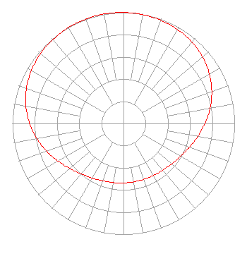 | ||||||||||||||||||
| Azimuth | Ratio | Azimuth | Ratio | Azimuth | Ratio | Azimuth | Ratio | ||||||||||||
| 0 | 0.999 | 10 | 0.995 | 20 | 0.987 | 30 | 0.975 | ||||||||||||
| 40 | 0.956 | 50 | 0.929 | 60 | 0.892 | 70 | 0.845 | ||||||||||||
| 80 | 0.792 | 90 | 0.735 | 100 | 0.679 | 110 | 0.630 | ||||||||||||
| 120 | 0.592 | 130 | 0.566 | 140 | 0.549 | 150 | 0.540 | ||||||||||||
| 160 | 0.535 | 170 | 0.534 | 180 | 0.535 | 190 | 0.540 | ||||||||||||
| 200 | 0.549 | 210 | 0.566 | 220 | 0.592 | 230 | 0.630 | ||||||||||||
| 240 | 0.679 | 250 | 0.735 | 260 | 0.792 | 270 | 0.845 | ||||||||||||
| 280 | 0.892 | 290 | 0.929 | 300 | 0.956 | 310 | 0.975 | ||||||||||||
| 320 | 0.987 | 330 | 0.995 | 340 | 0.999 | 350 | 1.000 | ||||||||||||
Structure Registration Number 1041890 Structure Type: GTOWER Registered To: Vertical Bridge CC FM, LLC Structure Address: Twr 2 - Rt 9g & Country Rd 14 Greenport, NY County Name: Columbia County ASR Issued: 11/08/2018 Date Built: 07/16/1998 Site Elevation: 57.9 m (190 ft.) Structure Height: 135.1 m (443 ft.) Height Overall: 135.9 m (446 ft.) Overall Height AMSL: 193.8 m (636 ft.) FAA Determination: 09/15/1998 FAA Study #: 98-AEA-2143-OE FAA Circular #: Paint & Light FAA Chapters: 1, 3, 12, 21 FAA CHAPTERS 3,4,5,13; 70/7460-1J; however, tower is utilizing grandfathered lighting levels per FCC Paragraphs 1,3,12,21. 42-12-04.3 N 73-50-07.5 W (NAD 83) 42-12-04.0 N 73-50-09.0 W (Converted to NAD 27) |
7136 S. Yale Avenue Suite 501 Tulsa, OK 74136 Phone: 918-664-4581 | Date: 08/26/2013 Application Certifier CAPSTAR TX LLC 2625 S. Memorial Drive, Suite A Tulsa, OK 74129 Applicant MICHAEL GUIDOTTI 2625 S Memorial Dr Suite A Tulsa, OK 74129 REGIONAL ENGINEER TROY LANGHAM Clear Channel 2625 S. Memorial Drive, Suite A Tulsa, OK 74129 | |||||||||||||||||