
FCCInfo.com
A Service of Cavell, Mertz & Associates, Inc.
(855) FCC-INFO
|
|
W264CJ from 07/06/1994 W264CJ from 04/28/1989 |
|
|
||||||||||||||||
|
|
W264CJ Channel: 264D 100.7 MHz Knoxville, Tennessee Service: FX - A translator or application for a translator. Facility ID: 61051 Fac. Service: FX Programming Delivery Method: Unspecified Status: License Application Accepted: 04/22/2016 Application Granted: 05/09/2016 File Number: BLFT-20160422AAS License Expires: 00/00/0000 Prefix Type: This is a license for a translator Application Type: License To Cover FCC Website Links: LMS Facility Details This Application CDBS Application Other W264CJ Applications Other W264CJ Applications in CDBS Including Superseded Applications Mailing Address Correspondence for W264CJ Correspondence related to application BLFT-20160422AAS Service Contour - Open Street Map or USGS Map (60 dBu) Service Contour - KML / Google Earth (60 dBu) Class: D, A Noncommercial educational operating with no more than 10W Site Location: 35-58-50.0 N 83-59-15.0 W (NAD 83) Site Location: 35-58-49.7 N 83-59-15.3 W (Converted to NAD 27) Effective Radiated Power: 0.25 kW Transmitter Output Power: 0.195 kW Antenna Center HAAT: 0 m Antenna Center AMSL: 440 m (1444 ft.) Antenna Center HAG: 81 m (266 ft.) Site Elevation: 359 m. (1178 ft.) Height Overall*: 85 m (279 ft.) (* As Filed In This Application, may differ from ASR Data, Below.) Directional Antenna Antenna Make/Model: None Antenna ID: 122405 Polarization:
| ||||||||||||||||||
| Antenna Data for Antenna Id: 122405 W264CJ FX File: BLFT-20160422AAS None - Service: FX | 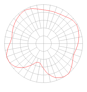 | ||||||||||||||||||
| Azimuth | Ratio | Azimuth | Ratio | Azimuth | Ratio | Azimuth | Ratio | ||||||||||||
| 0 | 0.860 | 10 | 0.851 | 20 | 0.851 | 30 | 0.860 | ||||||||||||
| 40 | 0.894 | 50 | 0.944 | 60 | 0.970 | 70 | 0.948 | ||||||||||||
| 80 | 0.916 | 90 | 0.882 | 100 | 0.846 | 110 | 0.824 | ||||||||||||
| 120 | 0.859 | 130 | 0.933 | 140 | 0.998 | 145 | 1.000 | ||||||||||||
| 150 | 0.986 | 160 | 0.923 | 170 | 0.801 | 180 | 0.639 | ||||||||||||
| 190 | 0.513 | 200 | 0.513 | 210 | 0.639 | 220 | 0.801 | ||||||||||||
| 230 | 0.923 | 240 | 0.986 | 250 | 0.998 | 260 | 0.933 | ||||||||||||
| 270 | 0.859 | 280 | 0.824 | 290 | 0.846 | 300 | 0.882 | ||||||||||||
| 310 | 0.916 | 320 | 0.948 | 330 | 0.970 | 340 | 0.944 | ||||||||||||
| 350 | 0.894 | ||||||||||||||||||
Structure Registration Number 1043276 Structure Type: TOWER Registered To: LOWE, TED H Structure Address: 3505 Peachwood Rd Knoxville, TN County Name: Knox County ASR Issued: 09/16/1998 Date Built: 01/01/1950 Site Elevation: 358.8 m (1177 ft.) Structure Height: 0.8 m (3 ft.) Height Overall: 84.8 m (278 ft.) Overall Height AMSL: 443.7 m (1456 ft.) FAA Determination: 09/03/1998 FAA Study #: 98-ASO-4824-OE FAA Circular #: 70/7460-1J Paint & Light FAA Chapters: 3, 4, 5, 13 35-58-50.0 N 83-59-15.0 W (NAD 83) 35-58-49.7 N 83-59-15.3 W (Converted to NAD 27) |
5106 Middlebrook Pike Knoxville, TN 37921-5970 Phone: 865-558-0900 | Date: 04/22/2016 Application Certifier RATEL BROADCASTING CO., INC 5106 Middlebrook Pike Knoxville, TN 37921 Applicant GEORGE S. CRISSEY Bromo Communications, Inc. 3600 Dallas Highway, Suite 230 - Pmb 164 Marietta, GA 30064 TECHNICAL CONSULTANT TED LOWE JR Ratel Broadcasting Co., Inc. 5106 Middlebrook Pike Knoxville, TN 37921 | |||||||||||||||||