
FCCInfo.com
A Service of Cavell, Mertz & Associates, Inc.
(855) FCC-INFO
|
|
|
|
|
||||||||||||||||
|
|
KBJF Channel: 213C 90.5 MHz Nephi, Utah Service: FM - A full-service FM station or application. Facility ID: 174640 Fac. Service: FM Status: License Application Accepted: 12/15/2011 Application Granted: 12/22/2011 File Number: BLED-20111215ABI License Expires: 00/00/0000 Prefix Type: This is a license for a noncommercial educational FM station Application Type: License To Cover FCC Website Links: LMS Facility Details This Application CDBS Application Other KBJF Applications Other KBJF Applications in CDBS Including Superseded Applications Mailing Address Correspondence for KBJF Correspondence related to application BLED-20111215ABI Service Contour - Open Street Map or USGS Map (60 dBu) Service Contour - KML / Google Earth (60 dBu) Public Inspection Files Facility Type: NON-COMMERCIAL EDUC. FM Class: C, A Zone II station; with exactly 100kW ERP and a class contour distance 72km-92km Site Location: 39-45-36.9 N 111-34-40.7 W (NAD 83) Site Location: 39-45-37.0 N 111-34-38.0 W (Converted to NAD 27) Effective Radiated Power: 75 kW Transmitter Output Power: 22.6 kW Antenna Center HAAT: 657.4 m (2157 ft.) Antenna Center AMSL: 2789 m (9150 ft.) Antenna Center HAG: 31 m (102 ft.) Site Elevation: 626.4 m. (2055 ft.) Height Overall*: 60.7 m (199 ft.) (* As Filed In This Application, may differ from ASR Data, Below.) Directional Antenna Antenna Make/Model: Propagation System Inc PSIFMP-6-DA six sections 0.9 wavelength spaced Antenna ID: 106054 Polarization:
| ||||||||||||||||||
| Antenna Data for Antenna Id: 106054 KBJF FM File: BLED-20111215ABI Propagation System Inc - PSIFMP-6-DA six sections 0.9 wavelength spaced Service: FM | 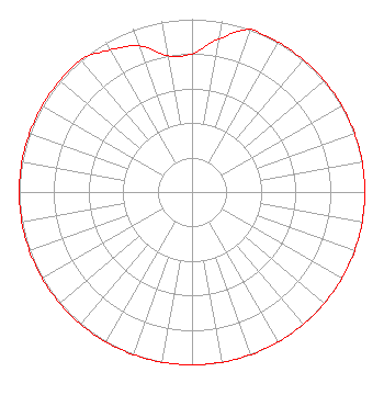 | ||||||||||||||||||
| Azimuth | Ratio | Azimuth | Ratio | Azimuth | Ratio | Azimuth | Ratio | ||||||||||||
| 0 | 0.800 | 10 | 0.900 | 20 | 1.000 | 30 | 1.000 | ||||||||||||
| 40 | 1.000 | 50 | 1.000 | 60 | 1.000 | 70 | 1.000 | ||||||||||||
| 80 | 1.000 | 90 | 1.000 | 100 | 1.000 | 110 | 1.000 | ||||||||||||
| 120 | 1.000 | 130 | 1.000 | 140 | 1.000 | 150 | 1.000 | ||||||||||||
| 160 | 1.000 | 170 | 1.000 | 180 | 1.000 | 190 | 1.000 | ||||||||||||
| 200 | 1.000 | 210 | 1.000 | 220 | 1.000 | 230 | 1.000 | ||||||||||||
| 240 | 1.000 | 250 | 1.000 | 260 | 1.000 | 270 | 1.000 | ||||||||||||
| 280 | 1.000 | 290 | 1.000 | 300 | 1.000 | 310 | 1.000 | ||||||||||||
| 320 | 1.000 | 330 | 0.950 | 340 | 0.900 | 350 | 0.800 | ||||||||||||
Structure Registration Number 1255962 [ASR Heights Differ from KBJF Application] Structure Type: TOWER Registered To: ACME Commercial Properties L.L.C. Structure Address: 7850 East Lake Canyon Road Indianola, UT County Name: Sanpete County ASR Issued: 05/03/2018 Date Built: 10/31/2006 Site Elevation: 2757.5 m (9047 ft.) Structure Height: 60.7 m (199 ft.) Height Overall: 60.7 m (199 ft.) Overall Height AMSL: 2818.2 m (9246 ft.) FAA Determination: 10/31/2006 FAA Study #: 2006-ANM-3509-OE Paint & Light FAA Chapters: NONE 39-45-36.4 N 111-34-40.5 W (NAD 83) 39-45-36.5 N 111-34-37.8 W (Converted to NAD 27) |
4002 N. 3300 E. Twin Falls, ID 83303 Phone: 208-733-3133 Not-for-Profit | Date: 12/15/2011 Application Certifier CALVARY CHAPEL OF TWIN FALLS, INC. Po Box 391 Twin Falls, ID 83303 Applicant LOIS MILLS Po Box 391 Twin Falls, ID 83303 APPLICATION TECHNICIAN CARY TEPPER Booth, Freret, Imlay And Tepper, Pc | |||||||||||||||||