
FCCInfo.com
A Service of Cavell, Mertz & Associates, Inc.
(855) FCC-INFO
|
|
|
|
|
||||||||||||||||
|
|
K294AZ Channel: 294D 106.7 MHz Eureka, California Service: FX - A translator or application for a translator. Facility ID: 138000 Fac. Service: FX Programming Delivery Method: Unspecified Status: License Application Accepted: 02/23/2005 Application Granted: 04/21/2005 File Number: BLFT-20050223ABW License Expires: 00/00/0000 Prefix Type: This is a license for a translator Application Type: License To Cover FCC Website Links: LMS Facility Details This Application CDBS Application Other K294AZ Applications Other K294AZ Applications in CDBS Including Superseded Applications Mailing Address Correspondence for K294AZ Correspondence related to application BLFT-20050223ABW Service Contour - Open Street Map or USGS Map (60 dBu) Service Contour - KML / Google Earth (60 dBu) Class: D, A Noncommercial educational operating with no more than 10W Site Location: 40-43-37.5 N 123-58-26.2 W (NAD 83) Site Location: 40-43-38.0 N 123-58-22.0 W (Converted to NAD 27) Effective Radiated Power: 0 kW Horiz. ; 0.25 kW Vert. Transmitter Output Power: 0.05 kW Antenna Center HAAT: 0 m Horiz.; 484.9 m Vert. Antenna Center AMSL: 0 m Horiz.; 850 m Vert. Antenna Center HAG: 0 m Horiz.; 37 m Vert. Site Elevation: 813 m. (2667 ft.) Height Overall*: 103 m (338 ft.) (* As Filed In This Application, may differ from ASR Data, Below.) Directional Antenna Antenna Make/Model: None Antenna ID: 16180 Polarization:
| ||||||||||||||||||
| Antenna Data for Antenna Id: 16180 K294AZ FX File: BLFT-20050223ABW None - Service: FX Pattern and Field Values Include a 315° Clockwise Rotation | 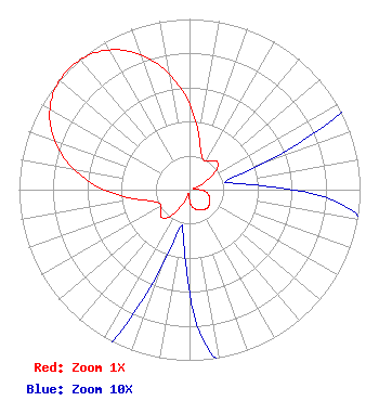 | ||||||||||||||||||
| Azimuth | Ratio | Azimuth | Ratio | Azimuth | Ratio | Azimuth | Ratio | ||||||||||||
| 5 | 0.405 | 15 | 0.250 | 25 | 0.190 | 35 | 0.207 | ||||||||||||
| 45 | 0.230 | 55 | 0.190 | 65 | 0.085 | 75 | 0.025 | ||||||||||||
| 85 | 0.035 | 95 | 0.088 | 105 | 0.115 | 115 | 0.132 | ||||||||||||
| 125 | 0.144 | 135 | 0.150 | 145 | 0.144 | 155 | 0.132 | ||||||||||||
| 165 | 0.115 | 175 | 0.088 | 185 | 0.035 | 195 | 0.025 | ||||||||||||
| 205 | 0.085 | 215 | 0.190 | 225 | 0.230 | 235 | 0.207 | ||||||||||||
| 245 | 0.190 | 255 | 0.250 | 265 | 0.405 | 275 | 0.600 | ||||||||||||
| 285 | 0.770 | 295 | 0.900 | 305 | 0.977 | 315 | 1.000 | ||||||||||||
| 325 | 0.977 | 335 | 0.900 | 345 | 0.770 | 355 | 0.600 | ||||||||||||
Structure Registration Number 1015105 Structure Type: Registered To: PWM, Inc. Structure Address: 1733 Barry Road Kneeland, CA County Name: Humboldt County ASR Issued: 08/04/2021 Date Built: 03/01/1985 Site Elevation: 813 m (2667 ft.) Structure Height: 91.4 m (300 ft.) Height Overall: 102.7 m (337 ft.) Overall Height AMSL: 915.7 m (3004 ft.) FAA Determination: 06/03/1997 FAA Study #: 97-AWP-1369-OE FAA Circular #: 70/7460-1J Paint & Light FAA Chapters: 3, 4, 5, 13 PREVIOUS STUDY 84-AWP-4-OE. 40-43-37.0 N 123-58-26.0 W (NAD 83) 40-43-37.5 N 123-58-21.8 W (Converted to NAD 27) |
1551 Queens Road Los Aneles, CA 90069 Phone: 310-927-6280 | Date: 02/23/2005 Application Certifier REDWOOD BROADCASTING COMPANY, INC. 603 F Street Eureka, CA 95501 Applicant ERIK C. SWANSON Hatfield & Dawson Consulting Engineers 9500 Greenwood Ave N Seattle, WA 98103 TECHNICAL CONSULTANT DAVID TILLOTSON Law Office Of David Tillotson 4606 Charleston Terrace, N.w. Washington, DC 20007-1911 | |||||||||||||||||