
FCCInfo.com
A Service of Cavell, Mertz & Associates, Inc.
(855) FCC-INFO
|
|
WXMG from 04/04/2013 WXMG from 03/06/1995 WXMG from 08/19/1981 WXMG from 06/01/1979 |
|  |
|
||||||||||||||||||||||||||||||
|
|
WXMG Channel: 238B 95.5 MHz Lancaster, Ohio Service: FS - A full service FM station auxiliary transmitting antenna or application. Facility ID: 72311 Fac. Service: FM Status: License Application Accepted: 10/13/2006 Application Granted: 12/20/2006 File Number: BXMLH-20061013AAF License Expires: 00/00/0000 Prefix Type: This is BXMLH Application Type: Minor Amendment FCC Website Links: LMS Facility Details This Application CDBS Application Other WXMG Applications Other WXMG Applications in CDBS Including Superseded Applications Mailing Address Correspondence for WXMG Correspondence related to application BXMLH-20061013AAF Service Contour - Open Street Map or USGS Map (54 dBu) Service Contour - KML / Google Earth (54 dBu) Public Inspection Files History Cards for WXMG Facility Type: FM STATION Class: B, A Zone I or I-A station; with 25kW-50kW ERP and a class contour distance 39km-52km Site Location: 39-40-32.2 N 82-40-34.6 W (NAD 83) Site Location: 39-40-32.0 N 82-40-35.0 W (Converted to NAD 27) Effective Radiated Power: 45 kW Transmitter Output Power: 17 kW Antenna Center HAAT: 150 m (492 ft.) Antenna Center AMSL: 444 m (1457 ft.) Antenna Center HAG: 64 m (210 ft.) Calculated Site Elevation: 380 m. (1247 ft.) Height Overall*: 72 m (236 ft.) (* As Filed In This Application, may differ from ASR Data, Below.) Directional Antenna Antenna Make/Model: Jampro JSCP-4R(DA) Antenna ID: 78902 Polarization: | |||||||||||||||||||||||||||||||||
| Antenna Data for Antenna Id: 78902 WXMG FS File: BXMLH-20061013AAF Jampro - JSCP-4R(DA) Service: FS | 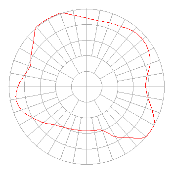 | |||||||||||||||||||||||||||||||||
| Azimuth | Ratio | Azimuth | Ratio | Azimuth | Ratio | Azimuth | Ratio | |||||||||||||||||||||||||||
| 0 | 0.880 | 10 | 0.860 | 20 | 0.870 | 30 | 0.890 | |||||||||||||||||||||||||||
| 40 | 0.930 | 50 | 0.940 | 60 | 0.920 | 70 | 0.870 | |||||||||||||||||||||||||||
| 80 | 0.790 | 90 | 0.760 | 100 | 0.800 | 110 | 0.900 | |||||||||||||||||||||||||||
| 120 | 1.000 | 130 | 1.000 | 140 | 0.860 | 150 | 0.740 | |||||||||||||||||||||||||||
| 160 | 0.600 | 170 | 0.570 | 180 | 0.570 | 190 | 0.570 | |||||||||||||||||||||||||||
| 200 | 0.580 | 210 | 0.600 | 220 | 0.640 | 230 | 0.720 | |||||||||||||||||||||||||||
| 240 | 0.800 | 250 | 0.890 | 260 | 0.920 | 270 | 0.880 | |||||||||||||||||||||||||||
| 280 | 0.810 | 290 | 0.770 | 300 | 0.820 | 310 | 0.890 | |||||||||||||||||||||||||||
| 320 | 1.000 | 330 | 1.000 | 340 | 1.000 | 350 | 0.930 | |||||||||||||||||||||||||||
Structure Registration Number 1035304 Structure Type: LTOWER Registered To: American Towers LLC Structure Address: 4000 Stoney Hill Road (202602-bt2/202603) Hocking, OH County Name: Fairfield County ASR Issued: 04/17/2018 Date Built: 02/21/1989 Site Elevation: 379.8 m (1246 ft.) Structure Height: 56.4 m (185 ft.) Height Overall: 71.6 m (235 ft.) Overall Height AMSL: 451.4 m (1481 ft.) FAA Determination: 03/26/2018 FAA Study #: 2018-AGL-4686-OE Paint & Light FAA Chapters: NONE PRIOR STUDY 2017-AGL-21942-OE 39-40-32.0 N 82-40-34.2 W (NAD 83) 39-40-31.8 N 82-40-34.6 W (Converted to NAD 27) |
1010 Wayne Avenue 14th Floor Silver Spring, MD 20910 Phone: 301-429-3200 | Date: 10/13/2006 Application Certifier CBS RADIO HOLDINGS INC. Suite 350 2175k Street Nw Washington, DC 20037 Applicant EDWIN L. NASS Suite 350 2175 K Street Nw Washington, DC 20037 EMPLOYEE OF PARENT CORPORATION EDWIN L. NASS Cbs | ||||||||||||||||||||||||||||||||
|
| |||||||||||||||||||||||||||||||||