
FCCInfo.com
A Service of Cavell, Mertz & Associates, Inc.
(855) FCC-INFO
|
|
|
|
|
||||||||||||||||
|
|
K226BW Channel: 226D 93.1 MHz Basalt, Colorado Service: FX - A translator or application for a translator. Facility ID: 138297 Fac. Service: FX Programming Delivery Method: Unspecified Status: License Application Accepted: 05/01/2015 Application Granted: 05/29/2015 File Number: BLFT-20150501AJG License Expires: 00/00/0000 Prefix Type: This is a license for a translator Application Type: License To Cover FCC Website Links: LMS Facility Details This Application CDBS Application Other K226BW Applications Other K226BW Applications in CDBS Including Superseded Applications Mailing Address Correspondence for K226BW Correspondence related to application BLFT-20150501AJG Service Contour - Open Street Map or USGS Map (60 dBu) Service Contour - KML / Google Earth (60 dBu) Class: D, A Noncommercial educational operating with no more than 10W Site Location: 39-21-09.9 N 107-05-35.2 W (NAD 83) Site Location: 39-21-10.0 N 107-05-33.0 W (Converted to NAD 27) Effective Radiated Power: 0.01 kW Transmitter Output Power: 0.012 kW Antenna Center HAAT: 125.5 m Horiz.; 0 m Vert. Antenna Center AMSL: 2539 m (8330 ft.) Antenna Center HAG: 8 m (26 ft.) Site Elevation: 2531 m. (8304 ft.) Height Overall*: 18 m (59 ft.) (* As Filed In This Application, may differ from ASR Data, Below.) Directional Antenna Antenna Make/Model: None Antenna ID: 116041 Polarization:
| ||||||||||||||||||
| Antenna Data for Antenna Id: 116041 K226BW FX File: BLFT-20150501AJG None - Service: FX Pattern and Field Values Include a 25° Clockwise Rotation | 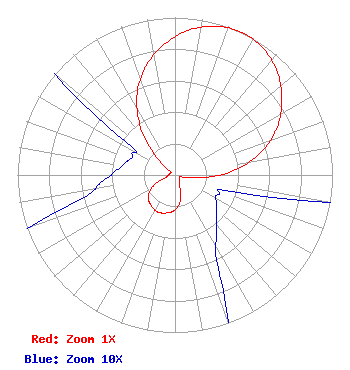 | ||||||||||||||||||
| Azimuth | Ratio | Azimuth | Ratio | Azimuth | Ratio | Azimuth | Ratio | ||||||||||||
| 5 | 0.920 | 15 | 0.979 | 25 | 1.000 | 35 | 0.979 | ||||||||||||
| 45 | 0.920 | 55 | 0.829 | 65 | 0.715 | 75 | 0.570 | ||||||||||||
| 85 | 0.388 | 95 | 0.187 | 105 | 0.045 | 115 | 0.030 | ||||||||||||
| 125 | 0.032 | 135 | 0.037 | 145 | 0.046 | 155 | 0.065 | ||||||||||||
| 165 | 0.142 | 175 | 0.202 | 185 | 0.234 | 195 | 0.250 | ||||||||||||
| 205 | 0.260 | 215 | 0.250 | 225 | 0.234 | 235 | 0.202 | ||||||||||||
| 245 | 0.142 | 255 | 0.065 | 265 | 0.046 | 275 | 0.037 | ||||||||||||
| 285 | 0.032 | 295 | 0.030 | 305 | 0.045 | 315 | 0.187 | ||||||||||||
| 325 | 0.388 | 335 | 0.570 | 345 | 0.715 | 355 | 0.829 | ||||||||||||
Structure Registration Number 1242352 Structure Type: TOWER Registered To: Pitkin County Translator Department Structure Address: Crown Mountain Site Basalt, CO County Name: Pitkin County ASR Issued: 12/30/2014 Date Built: 06/04/2004 Site Elevation: 2530.7 m (8303 ft.) Structure Height: 18.3 m (60 ft.) Height Overall: 18.3 m (60 ft.) Overall Height AMSL: 2549 m (8363 ft.) FAA Determination: 05/07/2002 FAA Study #: 02-ANM-0407-OE Paint & Light FAA Chapters: NONE 39-21-09.9 N 107-05-35.1 W (NAD 83) 39-21-10.0 N 107-05-32.9 W (Converted to NAD 27) |
530 E Main Street Garden Level Aspen, CO 81611 Phone: 970-920-5395 | Date: 05/01/2015 Application Certifier PITKIN COUNTY TRANSLATOR DEPARTMENT 530 E Main Street Garden Level Aspen, CO 81611 Applicant JON V BANKS 1015 Park West Drive Glenwood Springs, CO 81601 TECHNICAL CONSULTANT MELODIE A VIRTUE ESQ Garvey Schubert Barer 1000 Potomac Street, Nw 5th Floor Washington, DC 20007 | |||||||||||||||||