
FCCInfo.com
A Service of Cavell, Mertz & Associates, Inc.
(855) FCC-INFO
|
|
W261CV from 10/13/2004 |
|
|
||||||||||||||||
|
|
W261CV Channel: 261D 100.1 MHz Harrisonburg, Virginia Service: FX - A translator or application for a translator. Facility ID: 139550 Fac. Service: FX Programming Delivery Method: Unspecified Status: License Application Accepted: 07/02/2020 Application Granted: 07/24/2020 File Number: -0000116933 License Expires: 10/01/2027 Application Type: License To Cover FCC Website Links: LMS Facility Details This Application Other W261CV Applications Other W261CV Applications in CDBS Including Superseded Applications Mailing Address Correspondence for W261CV Correspondence related to application -0000116933 Service Contour - Open Street Map or USGS Map (60 dBu) Service Contour - KML / Google Earth (60 dBu) Facility Type: FM STATION Class: D, A Noncommercial educational operating with no more than 10W Site Location: 38-27-08.4 N 78-54-31.1 W (NAD 83) Site Location: 38-27-08.0 N 78-54-32.0 W (Converted to NAD 27) Effective Radiated Power: 0.25 kW Antenna Center HAAT: 0 m Antenna Center AMSL: 561 m (1841 ft.) Antenna Center HAG: 116 m (381 ft.) Site Elevation: 445 m. (1460 ft.) Height Overall*: 152 m (499 ft.) (* As Filed In This Application, may differ from ASR Data, Below.) Directional Antenna Antenna Make/Model: NIC BKG1/P-4L(SLANT45)(0.75WL) Antenna ID: 135317 Polarization: H
| ||||||||||||||||||
| Antenna Data for Antenna Id: 135317 W261CV FX File: -0000116933 NIC - BKG1/P-4L(SLANT45)(0.75WL) Service: FX | 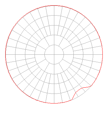 | ||||||||||||||||||
| Azimuth | Ratio | Azimuth | Ratio | Azimuth | Ratio | Azimuth | Ratio | ||||||||||||
| 0 | 1.000 | 10 | 1.000 | 20 | 1.000 | 30 | 1.000 | ||||||||||||
| 40 | 1.000 | 50 | 1.000 | 60 | 1.000 | 70 | 1.000 | ||||||||||||
| 80 | 1.000 | 90 | 1.000 | 100 | 1.000 | 110 | 1.000 | ||||||||||||
| 120 | 1.000 | 130 | 1.000 | 140 | 0.900 | 150 | 0.900 | ||||||||||||
| 160 | 1.000 | 170 | 1.000 | 180 | 1.000 | 190 | 1.000 | ||||||||||||
| 200 | 1.000 | 210 | 1.000 | 220 | 1.000 | 230 | 1.000 | ||||||||||||
| 240 | 1.000 | 250 | 1.000 | 260 | 1.000 | 270 | 1.000 | ||||||||||||
| 280 | 1.000 | 290 | 1.000 | 300 | 1.000 | 310 | 1.000 | ||||||||||||
| 320 | 1.000 | 330 | 1.000 | 340 | 1.000 | 350 | 1.000 | ||||||||||||
Structure Registration Number 1018184 Structure Type: TOWER Registered To: Tidewater Communications, LLC Structure Address: Rt 33 W Harrisonburg, VA County Name: Rockingham County ASR Issued: 05/06/2016 Date Built: 09/20/1985 Site Elevation: 445 m (1460 ft.) Structure Height: 151 m (495 ft.) Height Overall: 152 m (499 ft.) Overall Height AMSL: 597 m (1959 ft.) FAA Study #: 85-AEA-0299-OE Paint & Light FAA Chapters: 1, 3, 4, 13, 21 RED LIGHTS/PAINT 38-27-08.0 N 78-54-31.0 W (NAD 83) 38-27-07.6 N 78-54-31.9 W (Converted to NAD 27) |
73 Kercheval Avenue Suite 201 Grosse Pointe Farms, MI 48236 Phone: 313-886-7070 Limited Liability Company | Title: Vice President Date: 07/02/2020 Application Certifier TIDEWATER COMMUNICATIONS, LLC Tidewater Communications, Llc 73 Kercheval Avenue Suite 201 Grosse Pointe Farms, MI 48236 Applicant GARY S SMITHWICK, ESQ Smithwick & Belendiuk, P.c. 5028 Wisconsin Avenue, Nw Suite 301 Washington, DC 20016 Legal Counsel Justin Asher Asher Broadcast Consulting, Llc 579 Babcock Road Bronson, MI 49028-9347 Technical Consultant | |||||||||||||||||