
FCCInfo.com
A Service of Cavell, Mertz & Associates, Inc.
(855) FCC-INFO
|
|
|
|
|
||||||||||||||||
|
|
W257EI Channel: 257D 99.3 MHz Kannapolis, North Carolina Service: FX - A translator or application for a translator. Facility ID: 201605 Fac. Service: FX Programming Delivery Method: Unspecified Status: License Application Accepted: 10/17/2019 Application Granted: 02/24/2020 File Number: -0000086809 License Expires: 12/01/2027 Application Type: License To Cover FCC Website Links: LMS Facility Details This Application Other W257EI Applications Other W257EI Applications in CDBS Including Superseded Applications Mailing Address Correspondence for W257EI Correspondence related to application -0000086809 Service Contour - Open Street Map or USGS Map (60 dBu) Service Contour - KML / Google Earth (60 dBu) Facility Type: FM STATION Class: D, A Noncommercial educational operating with no more than 10W Site Location: 35-29-16.5 N 80-36-18.2 W (NAD 83) Site Location: 35-29-16.0 N 80-36-19.0 W (Converted to NAD 27) Effective Radiated Power: 0.25 kW Horiz. ; 0 kW Vert. Antenna Center HAAT: 0 m Antenna Center AMSL: 316 m Horiz.; 0 m Vert. Antenna Center HAG: 103 m Horiz.; 0 m Vert. Site Elevation: 213 m. (699 ft.) Height Overall*: 105 m (344 ft.) (* As Filed In This Application, may differ from ASR Data, Below.) Directional Antenna Antenna Make/Model: Kathrein-Scala Two YA7-FMH Antennas Oriented at 15 and 170 Degrees Antenna ID: 131923 Polarization: H
| ||||||||||||||||||
| Antenna Data for Antenna Id: 131923 W257EI FX File: -0000086809 Kathrein-Scala - Two YA7-FMH Antennas Oriented at 15 and 170 Degrees Service: FX | 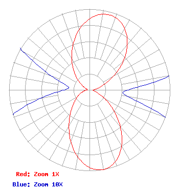 | ||||||||||||||||||
| Azimuth | Ratio | Azimuth | Ratio | Azimuth | Ratio | Azimuth | Ratio | ||||||||||||
| 0 | 0.877 | 10 | 0.950 | 20 | 0.950 | 30 | 0.874 | ||||||||||||
| 40 | 0.730 | 50 | 0.543 | 60 | 0.348 | 70 | 0.193 | ||||||||||||
| 80 | 0.103 | 90 | 0.048 | 100 | 0.049 | 110 | 0.104 | ||||||||||||
| 120 | 0.220 | 130 | 0.387 | 140 | 0.593 | 150 | 0.797 | ||||||||||||
| 160 | 0.943 | 170 | 1.000 | 180 | 0.960 | 190 | 0.841 | ||||||||||||
| 200 | 0.678 | 210 | 0.509 | 220 | 0.362 | 230 | 0.249 | ||||||||||||
| 240 | 0.175 | 250 | 0.115 | 260 | 0.062 | 270 | 0.031 | ||||||||||||
| 280 | 0.028 | 290 | 0.051 | 300 | 0.097 | 310 | 0.187 | ||||||||||||
| 320 | 0.301 | 330 | 0.441 | 340 | 0.596 | 350 | 0.752 | ||||||||||||
Structure Registration Number 1008252 Structure Type: TOWER Registered To: FORD BROADCASTING, INC. Structure Address: 910 Fairview St Kannapolis, NC County Name: Cabarrus County ASR Issued: 04/25/2000 Date Built: 01/01/1960 Site Elevation: 213.4 m (700 ft.) Structure Height: 104.4 m (343 ft.) Height Overall: 105.2 m (345 ft.) Overall Height AMSL: 318.6 m (1045 ft.) FAA Determination: 11/08/1996 FAA Study #: 96-ASO-5341-OE FAA Circular #: 70/7460-1J Paint & Light FAA Chapters: 3, 4, 5, 13 PREVIOUS 68-AT-024-OE. 35-29-16.0 N 80-36-18.0 W (NAD 83) 35-29-15.5 N 80-36-18.8 W (Converted to NAD 27) |
P.o. Box 1388 Kannapolis, NC 28082 Phone: 704-857-1101 Corporation | Title: President Date: 10/17/2019 Application Certifier FORD BROADCASTING, INC. Ford Broadcasting, Inc. Kannapolis, NC 28082 Applicant George S Crissey Bromo Communications, Inc. 3600 Dallas Highway, Suite 230 - Pmb 164 Marietta, GA 30064 Technical Consultant Arthur V Belendiuk Smithwick & Belendiuk, P.c. 5028 Wisconsin Avenue, N.w. Suite 301 Washington, DC 20016 | |||||||||||||||||