
FCCInfo.com
A Service of Cavell, Mertz & Associates, Inc.
(855) FCC-INFO
|
|
|
|
|
||||||||||||||||
|
|
KVCR Channel: 220B 91.9 MHz San Bernardino, California Service: FM - A full-service FM station or application. Facility ID: 58794 Fac. Service: FM Status: License 73.215 Station Application Accepted: 11/13/2019 Application Granted: 12/27/2019 File Number: -0000089116 License Expires: 12/01/2021 Application Type: License To Cover FCC Website Links: LMS Facility Details This Application Other KVCR Applications Other KVCR Applications in CDBS Including Superseded Applications Mailing Address Correspondence for KVCR Correspondence related to application -0000089116 Service Contour - Open Street Map or USGS Map (60 dBu) Service Contour - KML / Google Earth (60 dBu) Public Inspection Files History Cards for KVCR Facility Type: NON-COMMERCIAL EDUC. FM Class: B, A Zone I or I-A station; with 25kW-50kW ERP and a class contour distance 39km-52km Site Location: 33-57-57.4 N 117-17-09.1 W (NAD 83) Site Location: 33-57-57.3 N 117-17-06.0 W (Converted to NAD 27) Effective Radiated Power: 3.2 kW Max Effective Radiated Power: 3.8 kW Transmitter Output Power: 1.578 kW Antenna Center HAAT: 521 m (1709 ft.) Antenna Center AMSL: 965.9 m (3169 ft.) Antenna Center HAG: 70.1 m (230 ft.) Site Elevation: 895.8 m. (2939 ft.) Height Overall*: 105.2 m (345 ft.) (* As Filed In This Application, may differ from ASR Data, Below.) Directional Antenna Antenna Make/Model: Jampro JCPD-1/4 (4)-DA Antenna ID: 1005944 Polarization: | ||||||||||||||||||
| Antenna Data for Antenna Id: 1005944 KVCR FM File: -0000089116 Jampro - JCPD-1/4 (4)-DA Service: FM | 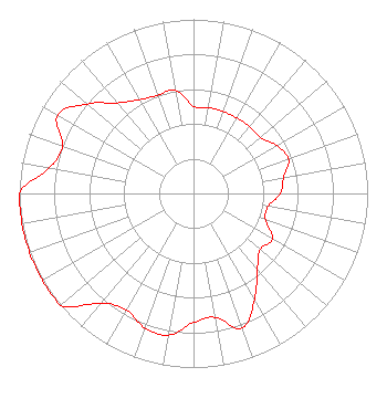 | ||||||||||||||||||
| Azimuth | Ratio | Azimuth | Ratio | Azimuth | Ratio | Azimuth | Ratio | ||||||||||||
| 0 | 0.500 | 10 | 0.500 | 20 | 0.500 | 30 | 0.500 | ||||||||||||
| 40 | 0.500 | 50 | 0.500 | 60 | 0.550 | 70 | 0.580 | ||||||||||||
| 80 | 0.525 | 90 | 0.500 | 100 | 0.434 | 110 | 0.440 | ||||||||||||
| 120 | 0.523 | 130 | 0.500 | 140 | 0.570 | 150 | 0.700 | ||||||||||||
| 160 | 0.820 | 170 | 0.723 | 180 | 0.742 | 190 | 0.827 | ||||||||||||
| 200 | 0.820 | 210 | 0.772 | 220 | 0.822 | 230 | 1.000 | ||||||||||||
| 240 | 1.000 | 250 | 1.000 | 260 | 1.000 | 270 | 1.000 | ||||||||||||
| 280 | 0.842 | 290 | 0.800 | 300 | 0.900 | 310 | 0.800 | ||||||||||||
| 320 | 0.679 | 330 | 0.622 | 340 | 0.600 | 350 | 0.600 | ||||||||||||
Structure Registration Number 1306140 Structure Type: LTOWER Registered To: SAN BERNARDINO COMMUNITY COLLEGE DISTRICT Structure Address: 10550 Box Springs Mt. Rd. Moreno Valley, CA County Name: Riverside County ASR Issued: 05/11/2018 Date Built: 01/25/2019 Site Elevation: 895.8 m (2939 ft.) Structure Height: 103.8 m (341 ft.) Height Overall: 105.2 m (345 ft.) Overall Height AMSL: 1001 m (3284 ft.) FAA Determination: 01/11/2018 FAA Study #: 2018-AWP-139-OE FAA Circular #: 70/7460-1L Paint & Light FAA Chapters: 4, 8, 12 PRIOR STUDY 2017-AWP-12160-OE 33-57-57.4 N 117-17-09.1 W (NAD 83) 33-57-57.3 N 117-17-06.0 W (Converted to NAD 27) |
701 S. Mt. Vernon Ave. San Bernardino, CA 92410 Phone: 909-388-6901 Government Entity | Title: Business Manager Date: 11/13/2019 Application Certifier SAN BERNARDINO COMMUNITY COLLEGE DISTRICT San Bernardino Community College District 701 S. Mt. Vernon Ave. San Bernardino, CA 92410 Applicant Michael R. Bennet Womble Bond Dickinson(us) Llp 1200 19th St., N.w., Suite 500 Washington, DC 20036 Ryan C. Wilhour Kessler And Gehman Associates, Inc. 507 Nw 60th St Ste D Gainesville, FL 32607 Consulting Engineer | |||||||||||||||||
| |||||||||||||||||||