
FCCInfo.com
A Service of Cavell, Mertz & Associates, Inc.
(855) FCC-INFO
|
|
|
|
|
||||||||||||||||
|
|
W285EU Channel: 285D 104.9 MHz High Point, North Carolina Service: FX - A translator or application for a translator. Facility ID: 142603 Fac. Service: FX Programming Delivery Method: Unspecified Status: License Application Accepted: 11/08/2019 Application Granted: 11/27/2019 File Number: -0000088440 License Expires: 12/01/2019 Application Type: License To Cover FCC Website Links: LMS Facility Details This Application Other W285EU Applications Other W285EU Applications in CDBS Including Superseded Applications Mailing Address Correspondence for W285EU Correspondence related to application -0000088440 Service Contour - Open Street Map or USGS Map (60 dBu) Service Contour - KML / Google Earth (60 dBu) Facility Type: FM STATION Class: D, A Noncommercial educational operating with no more than 10W Site Location: 35-57-21.5 N 80-00-21.1 W (NAD 83) Site Location: 35-57-21.0 N 80-00-22.0 W (Converted to NAD 27) Effective Radiated Power: 0.099 kW Antenna Center HAAT: 0 m Antenna Center AMSL: 352 m (1155 ft.) Antenna Center HAG: 70 m (230 ft.) Site Elevation: 282 m. (925 ft.) Height Overall*: 79 m (259 ft.) (* As Filed In This Application, may differ from ASR Data, Below.) Directional Antenna Antenna Make/Model: Nicom BKG77-3 Antenna ID: 134245 Polarization: H
| ||||||||||||||||||
| Antenna Data for Antenna Id: 134245 W285EU FX File: -0000088440 Nicom - BKG77-3 Service: FX | 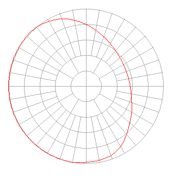 | ||||||||||||||||||
| Azimuth | Ratio | Azimuth | Ratio | Azimuth | Ratio | Azimuth | Ratio | ||||||||||||
| 0 | 0.797 | 10 | 0.731 | 20 | 0.676 | 30 | 0.628 | ||||||||||||
| 40 | 0.594 | 50 | 0.571 | 60 | 0.558 | 70 | 0.553 | ||||||||||||
| 80 | 0.558 | 90 | 0.571 | 100 | 0.594 | 110 | 0.628 | ||||||||||||
| 120 | 0.682 | 130 | 0.738 | 140 | 0.815 | 150 | 0.897 | ||||||||||||
| 160 | 0.953 | 170 | 0.973 | 180 | 0.983 | 190 | 1.000 | ||||||||||||
| 200 | 1.000 | 210 | 1.000 | 220 | 1.000 | 230 | 1.000 | ||||||||||||
| 240 | 1.000 | 250 | 1.000 | 260 | 1.000 | 270 | 1.000 | ||||||||||||
| 280 | 1.000 | 290 | 1.000 | 300 | 1.000 | 310 | 1.000 | ||||||||||||
| 320 | 0.991 | 330 | 0.963 | 340 | 0.923 | 350 | 0.862 | ||||||||||||
Structure Registration Number 1006665 Structure Type: BTWR Registered To: Triad Media Partners, Inc. Structure Address: 164 S Main St High Point, NC County Name: Guilford County ASR Issued: 06/23/2022 Date Built: 04/13/2016 Site Elevation: 281.9 m (925 ft.) Structure Height: 78.9 m (259 ft.) Height Overall: 78.9 m (259 ft.) Overall Height AMSL: 360.8 m (1184 ft.) FAA Determination: 04/13/2016 FAA Study #: 2016-ASO-1369-OE Paint & Light FAA Chapters: 1, 3, 11, 21 Continue As Is OM&L = PAINT/RED LIGHTS 35-57-21.0 N 80-00-21.0 W (NAD 83) 35-57-20.5 N 80-00-21.9 W (Converted to NAD 27) |
3012 Highwoods Blvd. Suite 201 Raleigh, NC 27604 Phone: 919-790-9392 Limited Liability Company | Title: Member And Manager Date: 11/08/2019 Application Certifier EASTERN AIRWAVES, LLC Eastern Airwaves, Llc 3012 Highwoods Blvd. Suite 201 Raleigh, NC 27604 Applicant Coe W. Ramsey Brooks, Pierce Et Al. 150 Fayetteville Street Suite 1700 Raleigh, NC 27601 Timothy L. Warner Timothy L. Warner, Inc. Timothy L. Warner, Inc. Post Office Box 8045 Asheville, NC 28814 TECHNICAL CONSULTANT | |||||||||||||||||